Download
1 / 53
530 likes | 762 Views
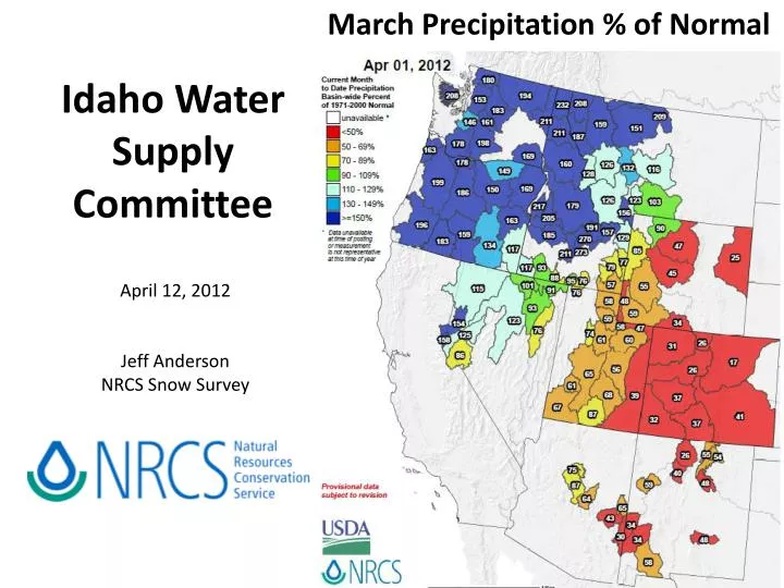
March Precipitation % of Normal. Idaho Water Supply Committee. April 12, 2012 Jeff Anderson NRCS Snow Survey. March 16, 2012 Rain on snow Pine Creek Pass ~6,700 ft (between Idaho Falls & Victor). SNOTEL Month to Date Precipitation % of Normal March 2012.

E N D
March Precipitation % of Normal Idaho Water Supply Committee April 12, 2012 Jeff Anderson NRCS Snow Survey March 16, 2012 Rain on snow Pine Creek Pass ~6,700 ft (between Idaho Falls & Victor)
SNOTEL Month to Date Precipitation % of Normal March 2012 March 2011
SNOTEL 14-Day Average Temperature Anomalies March 1-14 March 15-29 March 30-April 12
SNOTEL Maximum Temperature Records Monday Apr 9, 2012 Tuesday Apr 10, 2012
SNOTEL Maximum Temperature Anomaly Monday Apr 9, 2012 Tuesday Apr 10, 2012
Mountain Snowpack Change between March 1 and April 1, 2012 Big Lost +34% Priest +29% Payette +23% Little Wood +22% Salmon +19% Big Wood +16% Little Lost +16% Weiser +10% Boise + 6% Henrys Fk + 3% Teton - 2% Snake above Pal - 6% Goose/Trapper -12% Salmon Falls -15%Bear -15% Owyhee -20% Bruneau -21% Blackfoot -22%
Compare to March 1 to April 1, 2011 SWE % increased statewide from 6-38%
Mountain Snowpack Change between March 1 and April 1, 2012 Big Lost +34% Priest +29% Payette +23% Little Wood +22% Salmon +19% Big Wood +16% Little Lost +16% Weiser +10% Boise + 6% Henrys Fk + 3% Teton - 2% Snake above Pal - 6% Goose/Trapper -12% Salmon Falls -15%Bear -15% Owyhee -20% Bruneau -21% Blackfoot -22%
March 16, 2012 Rain on snow Pine Creek Pass ~6,700 ft (between Idaho Falls & Victor)
Top 2” were ~32.5F due to liquid water Otherwise 32F top to bottom Idaho State University Hydrology Field Day at Pine Creek Pass SNOTEL
+6 days with temps above freezing Rain = 0.6” Snowmelt = 1.0” Total runoff = 1.6” 17 sites saw snow melt begin in mid-March
Pine Creek Pass SNOTEL Water Year 2012 Melt starts ~2 weeks ahead of normal
Current Idaho and Upper Snake SNOTEL Snowmelt Status (based on 104 sites) 10 sites have melted out 75 sites had >0.3” SWE melt between Apr 8-11th 3 SNOTELs >9,000ft with >1” melt this week
Panhandle April 5, 2012 SAMUELS — A 60-foot-wide section of the forest road washed out on Friday, rendering it impassible to vehicles. Bonners County Daily Bee
SNOTEL Month to Date Precipitation % of Normal As of April 11, 2012
Boise Basin Statesman Jackson Kayak
Big Wood March 21, 2012 sunvalley.com
Big Wood April 12, 2012 sunvalley.com
March 15, 2012 Big Lost
Upper Snake Basin March 21, 2012 6,668ft elev
Upper Snake Basin April 12, 2012 • 6,668ft elev
Snake River Station Water Year 2012 • 6,900ft at Yellowstone South Entrance Melt starts ~3 weeks ahead of normal
Snake at Heise Apr-Sep 50% forecast March 1, 2012 3,830 KAF 92%
Snake at Heise Apr-Sep 50% Forecast March 1, 2012 3,830 KAF 92% April 1, 2012 3,290 KAF 79% Difference 540 KAF -13%
Bear Lake March 17, 2012 Jason Allen
Oakley Reservoir August 2011 March 31, 2012 41.6 KAF August 31, 2011 36.3 KAF Lynn Sessions
Salmon Falls January 2012 Jun 2011 149 kaf Mar 2012 89 kaf Jan 2002 12 kaf
Owyhees Looking west towards Owyhee Reservoir from Succor Creek area Steve Stuebner
April 3, 2012 Owyhee / Malheur Aerial Snow Course Flight Found 17 or 19 markers snow free