Download
1 / 12
120 likes | 275 Views
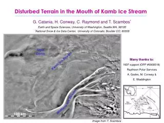
Disturbed Terrain in the Mouth of Kamb Ice Stream. G. Catania, H. Conway, C. Raymond and T. Scambos * Earth and Space Sciences, University of Washington, Seattle WA, 98195 * National Snow & Ice Data Center, University of Colorado, Boulder CO, 80309. Siple Dome. Many thanks to:

E N D
Disturbed Terrain in the Mouth of Kamb Ice Stream G. Catania, H. Conway, C. Raymond and T. Scambos* Earth and Space Sciences, University of Washington, Seattle WA, 98195 *National Snow & Ice Data Center, University of Colorado, Boulder CO, 80309 Siple Dome Many thanks to: NSF support (OPP #9909518) Raytheon Polar Services A. Gades, M. Conway & E. Waddington Kamb Ice Stream Stream Ice Whillans 100 km Image from T. Scambos
Kamb Ice Stream: Disturbed terrains Siple Dome Duckfoot KIS Kamb Ice Stream Engelhardt Ridge Stream Goosefoot Ice WIS 100 km Whillans Image from T. Scambos
Disturbed Terrains: Duckfoot Siple Dome Duckfoot Syncline? Duckfoot Syncline KIS margin (1849) Siple Dome Duckfoot Syncline? KIS margin (1624) MODIS Duckfoot Syncline Images: T. Scambos (NSIDC) KIS margin (1624) AVHRR
Duckfoot: Internal layers Duckfoot Syncline KIS margin (1624) glitch ~2 MHz Horizontal Distance (km)
Kamb Ice Stream: Disturbed terrains Siple Dome Duckfoot Kamb Ice Stream Engelhardt Ridge Stream Goosefoot Ice 100 km Whillans Image from T. Scambos
N Disturbed Terrains: Goosefoot Kamb Ice Stream KIS margin (1859) Goose Syncline Goose Syncline WIS margin (1859) MODIS Image from T. Scambos
Goosefoot: Internal Layers Goose Syncline KIS margin (1859) Goose Internal Boundary ~5 MHz Horizontal Distance (km)
Syncline Feature Disturbed Terrain Syncline Features and Disturbed Terrains Siple Dome Kamb Ice Stream Engelhardt Ridge Stream Ice 100 km Whillans
Syncline Feature Syncline Features: Mechanisms 0.1 ma-1 ↑Accumulation • Why does it melt in such a discrete zone? • Why does it melt at all? • Possible old grounding line? • high melt rates are associated with grounding lines (Rignot & Jacobs, 2002) • how far downstream is melt maintained? • what about other features? ↑Basal melt 0.1 ma-1
Disturbed Terrain Ridge BC Deep Diffractors: Mechanisms • What are the diffractors? • Freeze-on ice? • up to 25 m thick on KIS (Engelhardt) • Relict basal crevasses? • form at boundary between grounded and floating ice (Jezek and Bentley, 1983). • kept open and enlargened by tidal flexure. Could the lower end of KIS float?
Ice thickness in 1624 A.D. Goosefoot: 25-32 m above floatation Duckfoot: 47-61 m above floatation Floatation?? BEDMAP Disturbed Areas of KIS: - Goosefoot: 60-103 m above floatation - Duckfoot: 82-132 m above floatation Possible changes since 1624 A.D.: - accumulation ~ 17 m - ridge expansion ~ 36 m (Nereson, 2000) - isostatic rebound ~ 1? m (James, 1998) - post-stagnation freeze-on ~1-2 m (Kamb, 2001) - firn layer ~ 15.5 m (Bamber & Bentley, 1997) - longitudinal compression ?? - sea level rise ~ 0.5 m Conway Ridge Engelhardt Ridge Siple Dome from Lythe et al. 2001
Summary: • Disturbed Terrains: • No fast flow features, no near-surface diffractors • Outside of ice stream boundaries • Deep diffractors (~1/2 H) • Distorted, continuous internal layers • Syncline Features: • Strongly downwarped isochrones • Amplitude increases with depth, basal melting • Floatation Criteria for Disturbed Terrain: • Requires an additional loss of ~30-60 m ice • Similar to WIS ice plain 400 years ago.