Download
1 / 41
410 likes | 418 Views
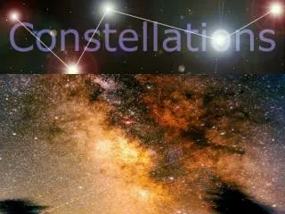
Star Maps – Constellations SNC1D. Expectations: D2.2, D3.6. Constellations. What is a star?. A STAR is a large sphere of glowing gases. Stars change over time. Which is the closest star to Earth? THE SUN! The sun is a medium sized star MUCH, MUCH larger than Earth.

E N D
Star Maps – ConstellationsSNC1D Expectations: D2.2, D3.6
What is a star? • A STAR is a large sphere of glowing gases. • Stars change over time. • Which is the closest star to Earth? • THE SUN! • The sun is a medium sized star • MUCH, MUCH larger than Earth
Stars as Tools for Navigation • The North Star is called Polaris and located directly above the North Pole. This star appears in the same place every night all year long. • In the Northern Hemisphere, if you find Polaris you will be able to tell which direction is north. • The Southern Hemisphere does not have a star to help you find its pole. Instead it has what is known as a Southern Cross. • The Southern Cross consists of 4 bright stars and some dimmer ones. All of these together point to the south pole.
Directions in the Sky • North is toward the North Celestial Pole • South is toward the South Celestial Pole • East is toward East on the ground (usually) • West is toward West on the ground (usually)
Patterns of Stars People of ancient time saw the constellations as character or animals in the sky. They made up stories to explain how the object, animal, or character came into the night sky. A pattern or group of stars in the sky is called a constellation.
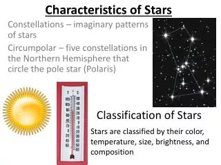
CONSTELLATIONS • Constellations are imaginary patterns of bright stars. • The ancient Greeks invented the constellations we call the twelve signs of the zodiac.
Constellations • A grouping of stars. • Ursa Major (big bear- can you see the Big Dipper?)
Constellations • Earth rotates on its axis, this makes most constellations appear to rise in the east and set in the west during the night. • Most constellations appear in many different positions in the sky as the Earth revolves around the sun. • There is a group of stars that appear in the sky all night long and all year long. It seems that these stars do not rise and set, but circle the Earth’s north pole each night. These stars are called circumpolar.
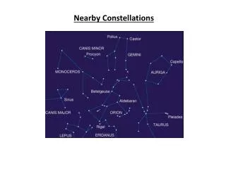
CONSTELLATIONS CONT. • There are eighty eight official constellations. • Some examples are: Big dipper, Orion, Gemini, Little dipper.
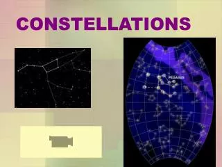
STAR CHARTS How can we identify constellations in the night sky? The use of a star chart can help us! A STAR CHART is a map of the stars in the night sky.
STAR CHARTS On a star chart, lines often connect the stars that might make up a constellation. Different star charts must be used at different times of the year and in different places on Earth. Many stars visible from the Southern hemisphere cannot be seen from the Northern hemisphere.
Star Map • Map of the night sky that shows the positions of the stars in a particular part of the sky. • Can be used for navigation. (still used by sailors) • All stars in the Northern Hemisphere appear to revolve around Polaris (the North Star). • The stars close to Polaris are visible all year. • Example: planisphere displays date and time to locate stars, constellations and galaxies.
What is a planisphere? • A planisphere is a map of the night sky. • It helps sky gazers to figure out where the constellations should be.
Before we begin… • We need to know some common basic terms, and we need to know directions.
Horizon • The horizon is the place where earth meets sky. Horizon
Zenith • the point of the celestial sphere that is directly over the observer and 90 degrees from all points on that person's horizon • The top of the sky!
Azimuth • the angular distance along the horizon between a point of reference, usually the observer's bearing, and another object
How to use a compass… • A compass always points North. • Make the compasses on the table line up with the N. • Point to East • Point to West
Ecliptic • The path across the sky celestial objects appear to follow over the year.
Let’s look at the planisphere Time Horizon Date The very center of the circle is the zenith, the highest place in the sky; right above your head! Everything inside the black oval is the sky Star Wheel copied from http://www.handsonuniverse.org/activities/uncleal/NorthStarwheel.pdf
Calendars • Many First Nations groups noted that that the appearance of certain patterns marked the changing of the seasons. • Ancient Egyptian farmers noticed that the annual flooding of the Nile River, used for crop irrigation would occur every 365 days when the Sun passed through the constellation Leo. • Others lined up stones with the Sun’s path in the sky and were able to track the start and end of each season.
Soltices and Equinoxes • Ancient Mayans built a giant pyramid that is aligned to the Sun’s movement in the sky. At sunset on the spring and fall equinoxes, a corner of the structure casts a shadow that resembles a plumed snake slithering down the pyramid steps.
On the day of the Winter Solstice, the burial chamber of Newgrange is illuminated for 17 minutes. • The ancient Irish used Newgrange for both a calendar and a sacred building for the community. • Newgrange dates from 3000 BC – much older than the pyramids of Egypt and Stonehenge in England Diagram of the passage inside Newgrange of the passage inside Newgrange
Stonehenge • Circular arrangement of giant stones and boulders. • At sunrise on the summer solstice every year, the Sun’s first rays strike a particular stone.
Other Views • Some West Coast Natives tell of the stars being formed when the sleeping Sun’s mouth spewed sparks through the smoke hole of it house. As the Sun slept, its brother, the Moon, rose in the east. • In other First Nations legends, lunar eclipses are the result of monsters in the sky swallowing the Moon.
Azimuth • The horizontal angular distance from north measured eastward along the horizon. (North 0º, East 90º, etc.)
Altitude • The angular height an object appears above the horizon, measured vertically.
Hand Angles • Finger 1º • Fist 10º • Outstretched hand 20º
Homework • Planisphere construction • Using the planisphere, answer the worksheet questions.