Download
1 / 39
390 likes | 395 Views
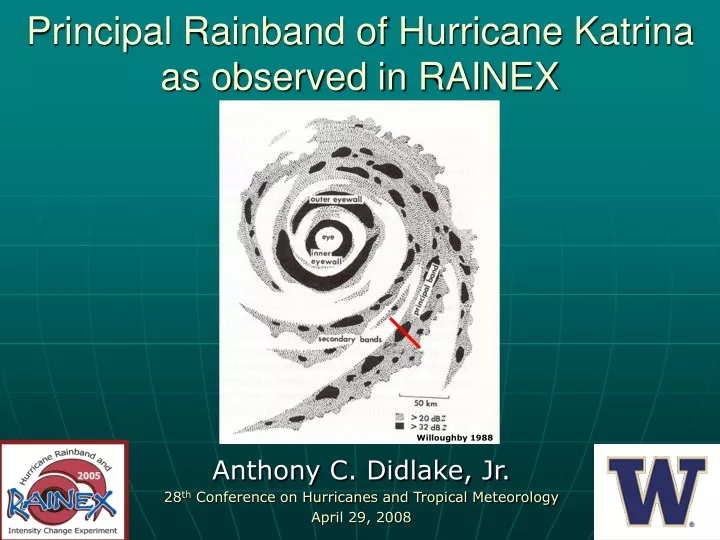
Principal Rainband of Hurricane Katrina as observed in RAINEX. Anthony C. Didlake, Jr. 28 th Conference on Hurricanes and Tropical Meteorology April 29, 2008. Willoughby 1988. Barnes et al. 1983. Cross-band structure. Low-level radial inflow overturns inside of leaning reflectivity tower

E N D
Principal Rainband of Hurricane Katrina as observed in RAINEX Anthony C. Didlake, Jr. 28th Conference on Hurricanes and Tropical Meteorology April 29, 2008 Willoughby 1988
Barnes et al. 1983 Cross-band structure • Low-level radial inflow overturns inside of leaning reflectivity tower • Downdraft within reflectivity tower continues as radial inflow
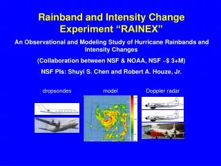
Hurricane Katrina (2005) ELDORA radar • Sampling resolution ~0.4 km
Similarities to Barnes et al. 1983 Hence and Houze 2008
Inner-edge downdraft • What causes it? • How often does it occur? • What are the effects of it?
Convective/stratiform classification • Similar to Steiner et al. 1995, TRMM satellite data classification Convective Stratiform Weak echo No echo
Rainband cross sections • Radial cross sections at regular angular intervals • 0.375° 109 cross sections • Cross section coordinates based on classification
Updrafts are strong and broad • Two downdraft regimes • Inner-edge downdrafts are slightly weaker and more localized
dBZ Buoyant air parcel
Conclusions • Overturning updraft, low-level downdraft, inner-edge downdraft • Inner-edge downdraft: • Convective scale feature, ~5 km • Creates sharp reflectivity gradient • Forced by rainband updrafts?
Buoyancy pressure-gradient acceleration field H H L L Buoyant air parcel
Idealized structure of a tropical cyclone downwind • Primary and Secondary eyewalls • Stationary Band Complex (SBC) • principal band • secondary band upwind Willoughby 1988
Autocorrelation along rainband B A D C
References • Willoughby, H.E., 1988: The dynamics of the tropical cyclone core. Aust. Met. Mag., 36, 183-191. • Barnes, G.M., E.J. Zipser, D. Jorgensen, and F. Marks, Jr., 1983: Mesoscale and convective structure of a hurricane rainband. J. Atmos. Sci., 40, 2125-2137. • Hence, D.A. and R.A. Houze, Jr., 2008: Kinematic structure of convective-scale rainband features in Hurricanes Katrina and Rita (2005). J. Geophys. Res., accepted.
“Strong” inner-edge downdrafts occur less frequently than “strong” updrafts • Inner-edge downdrafts occur right along the reflectivity gradient
Convective/stratiform classification • Technique used in Steiner et al. 1995, Yuter and Houze 1997, Yuter et al. 2005 • Algorithm separates convective regions from stratiform regions by comparing local reflectivity to background reflectivity • Tuning of algorithm required to recognize convective regions; the rest is designated as stratiform
Classification Algorithm • Convective center if: • Z Zti • Z-Zbg Zcc(Zbg) • Classified convective within R(Zbg) from convective center, remaining is classified stratiform (unless Z < Zwe) Zti = 45 dbZ Zwe = 20 dbZ R = 0.5+.23(Zbg-20) Rbg = 11 km a=9, b=45 Zcc Zbg
Convective pixels Stratiform pixels Statistics of reflectivity data dBZ dBZ Height (km) 2D frequency distributions (in % of height total) Yuter and Houze 1995
K1 x 10 -3 Beyond Barnes et al. (1983) - Deanna Hence
Strong downdrafts where horizontal velocity decreases with height
Tilting of vorticity tubes creates negative vertical vorticity
Negative vertical vorticity is stretched in region of convergence and advected downward. It is confined to the lower layers by divergence at the ocean surface.
Strong lower-level vertical vorticity is manifested in a local tangential wind maximum
Future work • Explore the roll of fluctuating updrafts and downdrafts in strength of storm circulation • Compare dynamics with other convective regimes: eyewall, secondary eyewall, outer rainbands • Analyze more ELDORA data volumes, N43 data, Rita rainbands • Compare observations with model simulations, analyze evolution of rainbands
Average tangential wind (m/s) altitude (km) distance (km)
Aircraft and instruments • US Naval Research Laboratory P3 (NRL) • ELDORA radar • Sampling resolution ~0.4 km • NOAA P3 (N42, N43) • Dropsondes and Doppler radar (dual-Doppler analysis)
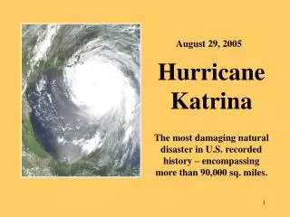
Intensity of Katrina (2005) Max Wind Speed (knots) 24 25 26 27 28 29 August Motivation for RAINEX How do interactions of environment, eyewalls, and rainbands in the mature storm… …lead to intensity changes like these?