Download
1 / 24
240 likes | 342 Views
Learn the key steps to achieve quality assurance in regional climate modeling following Dr. Warner's 14-step recommendations. Understand the importance of domain size, vertical resolution, nests, input data, and model options for successful modeling projects.

E N D
Best Practices in Regional Climate Modeling Dr. Michel d. S. Mesquita Bjerknes Centre for Climate Research, Uni Research michel.mesquita@uni.no https://sites.google.com/site/mmeclimate
Definition “…the maintenance of a desired level of quality in a service or product, especially by means of attention to every stage of the process of delivery or production” (Warner 2011, BAMS)
Lack of quality assurance • Not enough training and experience • Disregard or lack of care when considering an appropriate model setup and selection of parameterization schemes • “demands for quick results” Are models being “used wisely”? Warner(2011, BAMS)
Warner’s recommendations: • Define the scientific or practical objective of your study • Identify and develop a physical understanding of the atmospheric processes that must be simulated • Analyze all available observations • Prepare an experimental design plan Warner(2011, BAMS)
Warner’s recommendations: • Define the appropriate horizontal and vertical resolutions of the model • “Avoid the tendency to prematurely run the model, before the above-listed steps have been completed” Warner(2011, BAMS)
Remember this: • “…the sooner that the model is run, the longer a study will take” • One should avoid “the temptation to run the model before thoroughly understanding the prevailing meteorology…” Warner(2011, BAMS)
Warner’s recommendations: • Allow for spin up of the physical processes • Test the domain size Warner(2011, BAMS)
Warner’s recommendations: • Review the literature and prepare sensitivity studies • Understand that there are limitations to any model simulation • Prepare a verification plan Warner(2011, BAMS)
Warner’s recommendations: • Be well organized and keep a journal or log. Keep also your computer scripts and key model output files • Make use of good coding practices • Try to use open-source software Warner(2011, BAMS)
Activity (15 minutes)
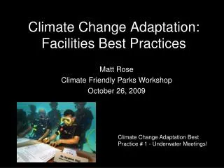
WRF Project • You have received funding to develop an early warning system for your country with respect to tropical storms • Activity: Using Warner’s 14-step approach, discuss with your group how you could prepare and create such a system. NASA satellite image of tropical storm Nate. Masters, J. (2011) Tropical storms and hurricane roundup. URL: http://www.bbc.co.uk/blogs/23degrees/2011/09/dr_jeff_masters_-_tropical_storms_and_hurricane.html
Designing a Numerical Experiment: Best Practices
Domain Size • How large does the domain need to be? • It will depend on the application • Simulations for a few days: Initial Conditions • Simulations for a few months, or years: Boundary Conditions • Domain sizes should not be too small: no less than 100x100 points • Where should the lateral boundaries be placed? • Avoid steep topography • Away from the region of interest Wang, W. (NCAR), URL: http://www.mmm.ucar.edu/wrf/users/tutorial/201207/WRF_nml_Wang.pdf
Vertical resolution • How many vertical levels should be used? • At least 30 or more levels • Vertical grid distance should not be larger than 1000 m • If finer horizontal grid size is used, consider increasing the vertical resolution Wang, W. (NCAR), URL: http://www.mmm.ucar.edu/wrf/users/tutorial/201207/WRF_nml_Wang.pdf
Wang, W. (NCAR), URL: http://www.mmm.ucar.edu/wrf/users/tutorial/201207/WRF_nml_Wang.pdf
Nests Warner(2011)
Nests • When should nests be used? • Input data resolution is coarse • Save computing resources • Remember: • The nest domain size should not be too small • The nest boundary should be kept away from the coarse domain boundary, and steep topography. Wang, W. (NCAR), URL: http://www.mmm.ucar.edu/wrf/users/tutorial/201207/WRF_nml_Wang.pdf
Input Data • Familiarize yourself with your input data: how good are the data? • Forecast data • Reanalysis data • Climate model data • How frequent should the boundary conditions be? • As frequent as possible Wang, W. (NCAR), URL: http://www.mmm.ucar.edu/wrf/users/tutorial/201207/WRF_nml_Wang.pdf
Model Options • Where should you start? • What do other people have success with? • Check the literature - references, papers • Use simple options first: • For example, • Graupelmay not be important if dx >> 10 km • mixed layer ocean model may not be needed • Use analyses from weather centers before trying to create your own dataset for both initial and lateral boundary conditions Wang, W. (NCAR), URL: http://www.mmm.ucar.edu/wrf/users/tutorial/201207/WRF_nml_Wang.pdf
Be Pragmatic! • Model results can be affected by many choices: • Domain configuration, both horizontal and vertical • Input data; • Lateral boundary conditions. • The model has limitations: • Physics: biases, may not handle certain process well Wang, W. (NCAR), URL: http://www.mmm.ucar.edu/wrf/users/tutorial/201207/WRF_nml_Wang.pdf