Download
1 / 14
140 likes | 146 Views
This study explores the use of radar data to improve rainfall estimation in the Tennessee River Valley. The researchers aim to reduce the TVA gauge network and transition to radar rainfall estimation using dual-polarimetric radar technology. The study also aims to prepare dual-pol rainfall algorithms for deployment with NEXRAD upgrade and support the NASA Global Precipitation Measurement Mission. The results show that radar rainfall estimates compare favorably to rain gauge totals, with radar capturing much of the heavy precipitation missed by rain gauges.

E N D
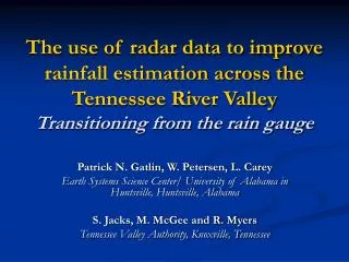
The use of radar data to improve rainfall estimation across the Tennessee River Valley Transitioning from the rain gauge Patrick N. Gatlin, W. Petersen, L. Carey Earth Systems Science Center/ University of Alabama in Huntsville, Huntsville, Alabama S. Jacks, M. McGee and R. Myers Tennessee Valley Authority, Knoxville, Tennessee
Motivation • Reduction of TVA gauge network • Radar rainfall estimation using ARMOR dual-polarimetric radar • Use of UAH infrastructure to “tune” current NEXRAD radars in Tennessee Valley • Prepare dual-pol rainfall algorithms for deployment with NEXRAD upgrade • Support NASA Global Precipitation Measurement Mission
Advanced Radar for Meteorological and Operational Research • Jointly owned by UAH and WHNT • Location: HSV, Huntsville, AL • C-band Doppler • SIGMET RVP8 and RCP8 • Dual-polarization • Transmits simultaneous H and V • Recieves H and V • Variables obtained: P, Z, V, W, ZDR = 10 log (Zh / Zv), ρhv = correlation between Zh & Zv , ΦDP = Φh – Φv KDP Conventional Doppler Radar Variables Zh, V, W T. Schuur Dual-Polarimetric Doppler Radar Additional variables ZDR, ΦDP, ρhv, KDP T. Schuur
Rainfall Mapping with ARMOR • H, V return power tells us about drop shape • Larger rain drops tend to be oblate spheroids • Smaller drops spherical • Can delineate regions of hail from rain and stratiform vs. convective • Specific differential attenuation (KDP) is good estimator of rainfall Improved rainfall algorithms adapted from Beard and Chuang (1987)
UAH Rainfall algorithm YES R = R(ZH) GOOD DATA? KDP 0.3 and ZH 35? YES R = R(KDP) NO YES ICE PRESENT? NO ZH BAD? R = R(ZHRAIN) YES NO R=BAD R=BAD NO KDP 0.3, ZH 35.0 dBZ ZDR 0.5 dB? NO NO ZH > 30 dBZ, ZDR 0.5 dB? 1-hr Accumulation 6-hr (N-hr) Accumulation YES R = R(ZH) YES (1) R(KDP,ZDR) (2) R(KDP) (3) R(ZH,ZDR) R = R(ZH,ZDR) R > 50 mm/hr, dBZ > 50 ,or Z, ZDR corr. too large ? YES R = R(KDP) ARMOR RAIN RATE ALGORITHM YES R =R(KDP,ZDR) KDP ≥ 0.5? YES R =R(ZH,ZDR) KDP< 0.5? no no Proprietary information, Walter A. Petersen, University of Alabama Huntsville
Moving away from “point” measurements: Radar Applications for TVA • NEXRAD radar network dual-polarimetric upgrade scheduled for 2009-2011: improved precipitation estimation a primary driver. • Can rain estimates using the new radar technology (i.e., dual-polarimetric) replace asignificant% of the TVA rain gauge network? • Demonstration project with UAH ARMOR radar in advance of NEXRAD dual-pol upgrade • ARMOR rain rate estimator, NO gauge input • 1-24 hour rain estimates over basin scales • Real time data and web-products • Facilitate/reintroduce radar precipitation estimation tailored to TVA needs • Future customer specific extensions (e.g., National Weather Service products, site specific terrain corrections etc. E.g., Summer season precipitation event Radar rainfall estimates compare favorably to individual rain gauge totals…………… BUTmuch of the heaviest precipitation missed the rain gauges altogether (this is typical)! Non-uniform nature of the rain field presents problems for rain gauges- but not for radars! Walter A. Petersen, University of Alabama Huntsville
Current TVA gauge network Gauges are sole rainfall input into streamflow model
Replacement of gauges with radar Radar and gauges used as separate rainfall inputs into streamflow model
Rainfall Products Development • 6-Hour Rainfall Accumulation Algorithm and Product development • Centered on ARMOR radar in Huntsville • TVA Basins and 25 km range rings indicated with white contours. • TVA gauge locations indicated as points http://www.nsstc.uah.edu/ARMOR/webimage/ • Creation of simple numeric table summarizing basin mean rainfall statistics (area mean, maximum, minimum and standard deviation of 1 km pixels in each basin). • ASCII or netCDF Data files available on demand (can modify formats and integration times as needed) • ASCII now distributed to TVA automatically
Quantitative Comparison of Radar and Rain Gauge Approach Individual Rain Gauge-Radar comparison Radar-TVA Basin area-means comparison • Bias ~ 20% (and uniform- good!) Random error 30-35% • Difference in “basin-means” methodology a likely factor • E.g. radar samples the whole basin, rain gauges sample a point (and the network is coarse) and then the point estimates are up-scaled to create a basin mean
How do we get improved precipitation estimates: UAH Infrastructure
Quantitative Comparison: Calibration Bias Corrected Pre-Cal correction Recent event after correction Bias = 19% Bias < < 1% Here the radar calibration is done using an internal consistency algorithm developed using dual-polarimetric variables. Bias reduced to < 0.1 %
Observed (red) Observed (red) Forecast Forecast Streamflow Forecast Verification Rain gauge only Radar only Forecast using Radar input more closely matches observed streamflow
Future Work • Create hourly basin rainfall maps for Tennessee River Valley from NEXRAD • Optimize radar rainfall estimation using UAH Infrastructure (ARMOR, MAX, MIPS, etc.) • Replacement of rain gauge with radar rainfall estimates as input into TVA streamflow model Contact Info Patrick Gatlin Earth Systems Science Center/ UAH phone: (256)-961-7910 e-mail: gatlin@nsstc.uah.edu