Download
1 / 21
220 likes | 229 Views
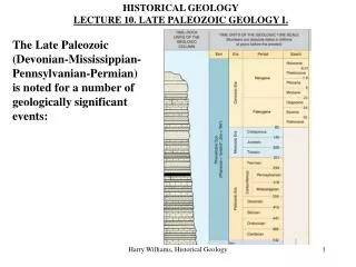
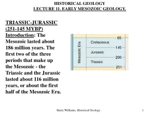
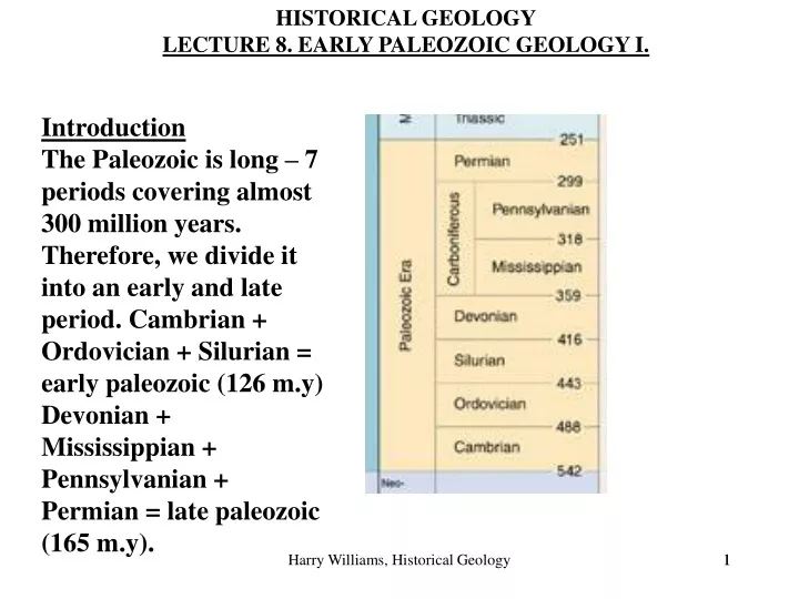
HISTORICAL GEOLOGY LECTURE 8. EARLY PALEOZOIC GEOLOGY I. Introduction The Paleozoic is long – 7 periods covering almost 300 million years. Therefore, we divide it into an early and late period. Cambrian + Ordovician + Silurian = early paleozoic (126 m.y)

E N D
HISTORICAL GEOLOGY LECTURE 8. EARLY PALEOZOIC GEOLOGY I. Introduction The Paleozoic is long – 7 periods covering almost 300 million years. Therefore, we divide it into an early and late period. Cambrian + Ordovician + Silurian = early paleozoic (126 m.y) Devonian + Mississippian + Pennsylvanian + Permian = late paleozoic (165 m.y). Harry Williams, Historical Geology 1
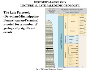
Both these "periods" have a similar geologic history characterized mainly by large scale transgressions and regressions, and orogenic events. Each period can be examined in terms of major factors that shaped the geologic record - these factors are: 1. Paleogeography 2. Transgressions and Regressions 3. Orogenies Why are these important?...... Harry Williams, Historical Geology 2
1. Paleogeography: Location of land and sea areas. Land - often erosion, non deposition; exception = back-arc basin sedimentation, coastal plains, arkosic sandstone, volcanics. Sea (including epeiric seas) - deposition of clastics and carbonates. Paleolatitude - refers to the location of the North American craton in relationship to the Equator and Poles. Controlled paleoclimate, rock types e.g. warm/hot climates -> carbonates, coral reefs, evaporates, sand dunes. Cold climates -> glacial deposits. Harry Williams, Historical Geology 3
2. Transgressions and Regressions Occurred mainly because of tectonic plate movements. TRANSGRESSION -> shallow ocean in PLATFORM areas ("Epeiric seas" - sea over a continent), which underwent DEPOSITION and formation of sedimentary rocks. REGRESSION -> land exposed - usually underwent EROSION (with some exceptions, including arkosic sandstones) and removal of rocks. Because marine conditions often meant deposition and terrestrial conditions often meant erosion, a major transgression followed by a regression created a sequence of strata capped by an UNCONFORMITY. (on board) Harry Williams, Historical Geology 4
The green zone represents a cratonic sequence (rocks laid down during a transgression and regression). The lower boundary of the green zone is a transgression; the upper boundary is a regression. Harry Williams, Historical Geology 5
The sequence is thicker and more complete near the craton edges since these areas are the first to be covered by the transgressing sea and the last to be uncovered by the regressing sea. The Paleozoic contains a number of these major depositional sequences - the SAUK in Cambrian time and the TIPPECANOE in Ordovician/Silurian time. OROGENIES Mostly resulting from plate convergence and continent-continent collisions. Mountain chains were constructed along craton margins, consisting of uplifted, folded, metamorphosed marine and terrestrial deposits - often accompanied by intrusive and extrusive igneous rocks (i.e. distinctive suites of rocks). These mountain chains were subject to erosion and became sediment sources for later deposits - shales + greywackes in deep marine basins; quartz sands and shales in shallow platform seas; fluvial sandstones and conglomerates in terrestrial areas (i.e. more rocks). Harry Williams, Historical Geology 6
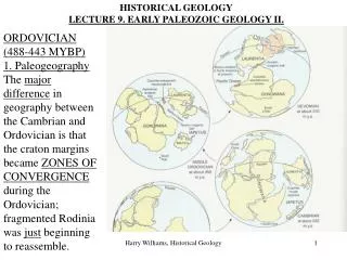
1. Paleogeography 750 million years ago Late Cambrian (514 million years ago): Rodinia had broken up. The major land masses (Laurentia, Baltica, Kazakhstania, Siberia, China and Gondwana) were moving apart. 7
The North American craton lay along the Equator during Cambrian time. Note: the outline of North America in it’s “upright” position is provided only as a frame of reference. Harry Williams, Historical Geology
CAMBRIAN 1. Paleogeography The North American craton lay along the Equator during Cambrian time. The climate was warm/hot. The craton land area was towards the “northeast” (today) and eroding. Shallow platform seas existed around the margins of the craton, especially in the south. The deposits forming in these seas were gradational from sand-shale-carbonate, depending on depth of water/distance from shore. The break-up of Rodinia had crated linear marine basins (seaways) around the edge of the craton: Appalachian seaway to the S.E./E. Cordilleran seaway to the W. Franklin seaway to the N. These were sites for SHALE deposition. Harry Williams, Historical Geology 9
2. Transgressions/Regressions The Cambrian was a time of TRANSGRESSION - the SAUK TRANSGRESSION. As the coastline moved inland, a typical transgressive sequence was deposited: COASTAL SANDS SHALLOW MARINE SHALES DEEPER MARINE LIMESTONES A good example is provided by the Cambrian deposits exposed in the Grand Canyon: Old at bottom Young on top Harry Williams, Historical Geology 10
Transgressivesequence: TEPEATS SANDSTONE (coastal sand) BRIGHT ANGEL SHALE (shallow marine shale) MAUV LIMESTONE (deeper marine limestone). Remember Lab 1? Harry Williams, Historical Geology 11
O: lower Cambrian. G: middle Cambrian. The sequence records the transgression and the migration of the coastline from west to east.
Due to the slow progress of the transgression, the same sequence did not develop everywhere at the same time. E.g. Bright Angel Shale is lower Cambrian in California; middle Cambrian in the Grand Canyon. This is an example of a “Diachronous Rock Unit” (a layer of rock of non-uniform age). Above: one layer of sandstone; younger to the left, older to the right. Harry Williams, Historical Geology 13
Sedimentary environments near the peak of the Sauk transgression (late Cambrian). This map shows inland areas where the late Cambrian coastlines would have been located. There are coastal sandstones, shallow marine shales and deeper marine carbonates. Orogenic activity is recorded by volcanic rocks.
The end of the Sauk transgression (Sauk regression) is marked by a widespread erosional unconformity, which in turn is overlain by the Tippecanoe cratonic sequence. The erosion is prominent above an uplift that formed in the craton.
Broad warping of the craton formed these basins and domes during and after deposition of these rocks. Other uplifts are related to orogenic activity.
Tepeats sandstone in the Grand Canyon records lower Cambrian Suak transgressive sands. St. Peter sandstone records middle Ordovician, Tippecanoe transgressive sands.
Are there any lower Paleozoic rocks around DFW? Not exactly, they are west of Denton and they are upper Paleozoic (Pennsylvanian and Permian). They are in the Fort Worth Basin. Lower Paleozoic rocks are underneath them and are exposed around the Llano Uplift in the Hill Country. Harry Williams, Historical Geology
Section through the western part of the Fort Worth Basin Harry Williams, Historical Geology
3. Orogenies Harry Williams, Historical Geology 20
3. Orogenies The Cambrian was mostly a stable period for North America. The fragments of Rodinia were moving APART, so the edges of the craton were mainly PASSIVE MARGINS -> no convergence; no subduction; no orogenies. Harry Williams, Historical Geology 21