Download
1 / 17
170 likes | 242 Views
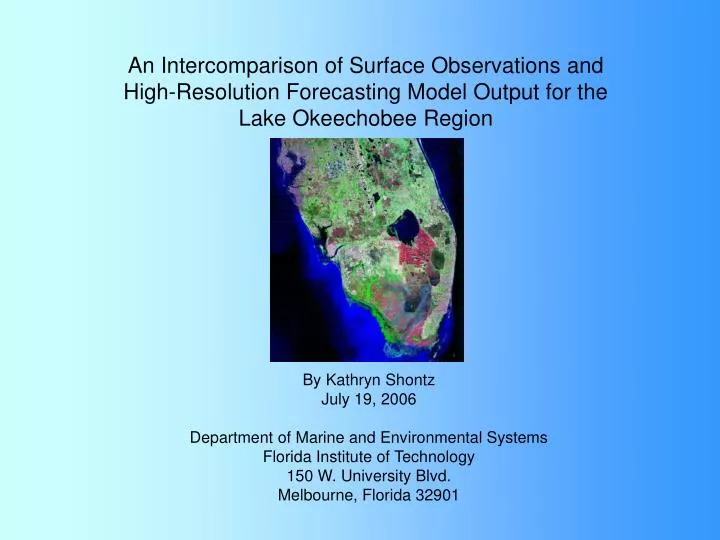
An Intercomparison of Surface Observations and High-Resolution Forecasting Model Output for the Lake Okeechobee Region. By Kathryn Shontz July 19, 2006 Department of Marine and Environmental Systems Florida Institute of Technology 150 W. University Blvd. Melbourne, Florida 32901.

E N D
An Intercomparison of Surface Observations and High-Resolution Forecasting Model Output for the Lake Okeechobee Region By Kathryn Shontz July 19, 2006 Department of Marine and Environmental Systems Florida Institute of Technology 150 W. University Blvd. Melbourne, Florida 32901
Introduction • Purpose • Idealized model of a Lake Breeze • Observational and Analytical Methods • Lake Breeze on June 8, 2006: Graphical and Satellite Data • What is the Weather Research and Forecasting Model? • Model Output: Image and Graphical Data • Comparison between Observed and Model Data • Conclusions • Future Considerations
Purpose • Gauge Weather Research and Forecasting (WRF) model representation of the lake breeze phenomenon with respect to Lake Okeechobee • Evaluate the model performance in terms of forecasting capabilities
Idealized Lake Breeze www.islandnet.com/.../wxdrphotos/lakebrz.gif • Meso-gamma scale turbulent vertical flow (2-20 km) • Occurs in afternoon due to solar heating and flows inland less than characteristic width of lake (Segal, 1997) • Known to extend vertically for several hundred meters (Segal, 1997) • Most events occur in the month of lowest average wind speed and maximum solar heating (Laird, 2001)
Synoptic scale influence on the lake breeze evolution 180 90 270 360 ~150 + easterly large scale (synoptic flow)
Methods and Observations • Weather Station Data: K4JHI • Only Okeechobee Station • Sensible Weather Elements • WRF Model Output • Data Processing • Grads Output and Images K4JHI Palmdale Lake Okeechobee Mesowest Achieve, 2006
Results Sunrise Lake Breeze
Satellite Imagery Sea Breeze Front Lake Breeze Front Lake Okeechobee
What is the Weather Research and Forecasting (WRF) Model? T, p, u, v, w,q • Most current regional forecast model • Numerical weather prediction in 4-dimensional space • Spatial resolution from meters to tens of kilometers • Prognostic dynamical model that incorporates actual data with physical parameterizations (e.g., radiation, boundary layer, cloud physics). WRF Configuation Domain size Hz Resolution (4 km), Vertical Resolution? Initial/Boundary Conditions (NAM)
WRF Model Run of June 8, 2006: 5 am - 8 pm 8:00 AM 11:00 AM 2:00 PM 5:00 PM 8:00 PM 5:00 AM 950 Model Winds at 5:00 PM
Time Series Data from WRF Output N E W S www.jimporter.orglakesokeechobeelake.jpg
Comparison of Observations and Model Data sunrise/mixing
Conclusions • Possible lake breeze boundary observed in temperature, winds, and dew point at station K4JHI • Temperature, dew point and relative humidity are not handled well by the WRF model (especially the diurnal temperature cycle) • 4-km resolution model is too inaccurate to use instead of weather observations • Possible problems/issues • Sparse observations • Rounding of data • Observed lake temperature ~ 29 C, model ? • Temporal model output insufficient • Timing/distribution of convection • model parameterizations (land surface, radiation, skin temperature, soil moisture) • Synoptic scale flow appears to be different than observed
Future Considerations • Repeated trials especially during other pressure regimes • 1-km resolution or smaller output • Enhanced monitoring equipment on all lake shores www.nasa.gov/.../71654main1_florida_mosaic_t.jpg
References Laird, N.F. et al. “Lake Michigan Lake Breezes: Climatology, Local Forcing, and Synoptic Environment.” Journal of Applied Meteorology: Vol. 40, no. 3, pp. 409-424. 2001. Segal, M. et al. “Small Lake Daytime Breezes: Some Observational and Conceptual Evaluations.” Bulletin of the American Meteorological Society: Vol. 78, no. 6, pp. 1135-1148. June 1997. Weather Station History: K4JHI in Okeechobee City, FL. Taken from Mesowest database.http://www.met.utah.edu/cgi-bin/droman/meso_base.cgi?stn=AR914 Questions? Christopher Flanary, Natalie Lamberton, Kelli Zargiel
Vertical Wind Profile: Surface to 1.5 km at 5:00 PM 1000 mb 950 mb 900 mb 850 mb