Download
1 / 24
240 likes | 388 Views
geologic hazards & space geodesy. part 1: Introduction. thanks. Ken Hudnut, USGS Roger Bilham, University of Colorado USAID, ADPC, USGS Thai National Disaster Warning Center Chulalongkorn University. Geodesy. measuring the shape of the earth…. and measuring changes. Many applications.

E N D
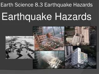
geologic hazards & space geodesy part 1: Introduction
thanks • Ken Hudnut, USGS • Roger Bilham, University of Colorado • USAID, ADPC, USGS • Thai National Disaster Warning Center • Chulalongkorn University
Geodesy measuring the shape of the earth…
What changes in the shape of the earth are associated with tsunamis?
What causes tsunamis? • Fault slip caused the sea floor to deform (4-5 meters up, and 10-11 meters to the west) • This pushed the water and formed the tsunami • Model by Dr. Chen Ji at Caltech, funded by USGS external research program
WEST EAST Indian Ocean Sumatra Before events Where the India plate is pushed down beneath the Banda micro-plate, it is being SUBDUCTED. Where the two plates’ surfaces are sliding past each other, it gets caught for hundreds of years and then the stored stress is released in a big earthquake.
Before events • Temporal variations do occur: • Clustering (e.g., Basin & Range, ECSZ, Asia) • Discrepant geological and geodetic rates • Sequences involving fault interaction (e.g., Joshua Tree - Landers - Big Bear - Hector Mine; Anatolian system, etc.) • Implement robust research findings into hazard assessment Courtesy Anke Friedrich
During events Courtesy of Space Imaging and USGS CRSSP
So how can GPS help? O. Konca, Caltech