Download
1 / 83
830 likes | 834 Views
Learn about the cost of the Louisiana Purchase, the original treaty, and the influential figures involved in this significant event in American history.

E N D
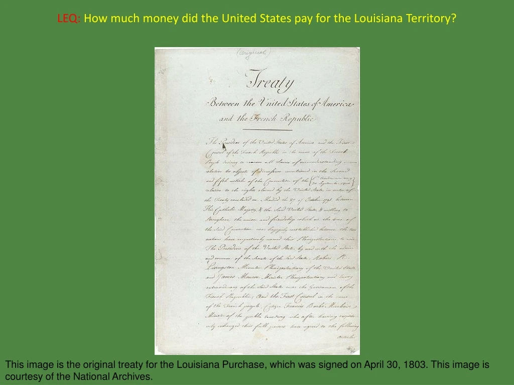
LEQ:How much money did the United States pay for the Louisiana Territory? This image is the original treaty for the Louisiana Purchase, which was signed on April 30, 1803. This image is courtesy of the National Archives.
LEQ:How much money did the United States pay for the Louisiana Territory?$15 million This image is the original treaty for the Louisiana Purchase, which was signed on April 30, 1803. This image is courtesy of the National Archives.
The Louisiana Purchase Basics This map shows the current states of the United States with the territory acquired during the Louisiana Purchase containing a green overlay. This image is courtesy of Wikimedia Commons.
The Louisiana PurchaseVocabulary This image is from wordinfo.info.
To give up items, such as land. This image is titled Napoleon Bonaparte Discussing the Louisiana Purchase Treaty With Talleyrand and Marbois. This image was created by Andrew Castaigne in 1904. This image is courtesy of knowla.org.
CedeTo give up items, such as land. This image is titled Napoleon Bonaparte Discussing the Louisiana Purchase Treaty With Talleyrand and Marbois. This image was created by Andrew Castaigne in 1904. This image is courtesy of knowla.org.
Spain had ceded the Louisiana Territory to France before the United States purchased the Louisiana Territory. This image shows James Monroe shaking hands with French Minister Francois de Barbe-Marbois (1745-1837), and Robert Livingston signing the Louisiana Purchase. This image was created by H. Davidson in 1904. This image is courtesy of unomaha.edu.
A prearranged combat between two persons to settle a private quarrel. This image shows Aaron Burr on the left meeting Alexander Hamilton, right, at Weehawken, New Jersey on the morning of July 11, 1804. This image is courtesy of nymag.com.
DuelA prearranged combat between two persons to settle a private quarrel. This image shows Aaron Burr on the left meeting Alexander Hamilton, right, at Weehawken, New Jersey on the morning of July 11, 1804. This image is courtesy of nymag.com.
Aaron Burr killed Alexander Hamilton in one of the most famous duels in American history. Hamilton fired first, he missed, and then Burr fired. The bullet went into Hamilton’s abdomen in the area of his right hip. Hamilton died the next day, and Burr became a political outcast. Some people who saw the duel thought that Hamilton deliberately missed Burr, while Burr purposely aimed at Hamilton. This image is courtesy of Uncyclomedia Commons.
The Louisiana PurchasePeople to Meet This painting by Stanley Meltzoff shows the return of the Corps of Discovery to St. Louis, Missouri. This image is courtesy of explorepahistory.com.
The Third President of the United States. Thomas Jefferson (1743-1826) was President for two terms, from 1801-1809. This painting was created by Rembrandt Peale (1778-1860) in 1800. This image is courtesy of Wikimedia Commons.
Thomas JeffersonThe Third President of the United States. Thomas Jefferson (1743-1826) was President for two terms, from 1801-1809. This painting was created by Rembrandt Peale (1778-1860) in 1800. This image is courtesy of Wikimedia Commons.
The United States Ambassador to France who negotiated the Louisiana Purchase. Robert Livingston (1746-1813) served as the Chancellor or Governor of New York State for 25 years. He administered the Oath of office to George Washington at Washington’s first inauguration. This painting was created by Gilbert Stuart (1755-1828) circa the late 1700s. This image is courtesy of Wikimedia Commons.
Robert LivingstonThe United States Ambassador to France who negotiated the Louisiana Purchase. Robert Livingston (1746-1813) served as the Chancellor or Governor of New York State for 25 years. He administered the Oath of office to George Washington at Washington’s first inauguration. This painting was created by Gilbert Stuart (1755-1828) circa the late 1700s. This image is courtesy of Wikimedia Commons.
Virginian who was sent to France to help negotiate the Louisiana Purchase. He later became the fifth President of the United States. James Monroe (1758-1831) was the last president who was considered to be a “Founding Father” of the United States, and he was the last of the “Virginia dynasty” of United States presidents. This painting was created by Gilbert Stuart (1755-1828) in 1803. The painting is courtesy of wikiart.org..
James MonroeVirginian who was sent to France to help negotiate the Louisiana Purchase. He later became the fifth President of the United States. James Monroe (1758-1831) was the last president who was considered to be a “Founding Father” of the United States, and he was the last of the “Virginia dynasty” of United States presidents. This painting was created by Gilbert Stuart (1755-1828) in 1803. The painting is courtesy of wikiart.org..
Thomas Jefferson’s secretary, who was one of the leaders of the Corps of Discovery that was sent to explore the newly acquired Louisiana Territory. Meriwether Lewis (1774-1809) was considered to be a troubled person who died of gunshot wounds in what was either a murder or a suicide . This image was painted by Charles Willson Peale (1741-1827) circa 1807. This image is courtesy Wikimedia Commons.
Meriwether LewisThomas Jefferson’s secretary, who was one of the leaders of the Corps of Discovery that was sent to explore the newly acquired Louisiana Territory. Meriwether Lewis (1774-1809) was considered to be a troubled person who died of gunshot wounds in what was either a murder or a suicide . This image was painted by Charles Willson Peale (1741-1827) circa 1807. This image is courtesy of Wikimedia Commons.
A former army officer who was one of the leaders of the Corps of Discovery that was sent to explore the newly acquired Louisiana Territory. William Clark (1770-1838) was a younger brother of American Revolutionary War hero George Rogers Clark (1752-1818). This image was painted by Charles Willson Peale (1741-1827) circa 1810. This image is courtesy of Wikimedia Commons.
William ClarkA former army officer who was one of the leaders of the Corps of Discovery that was sent to explore the newly acquired Louisiana Territory. William Clark (1770-1838) was a younger brother of American Revolutionary War hero George Rogers Clark (1752-1818) who taught William skills on how to survive in the wilderness. This image was painted by Charles Willson Peale (1741-1827) circa 1810. This image is courtesy of Wikimedia Commons.
Shoshone Indian woman who accompanied the Lewis and Clark expedition as an interpreter and as a guide. Sacagawea(1778-1812) was captured by a rival Native American group, and at the age of approximately 13 was married by Toussaint Charbonneau a French-Canadian fur trader. This is a detail of a painting which is titled “Lewis & Clark at Three Forks.” This image was painted by Edgar Samuel Paxson (1852-1919) in 1912. This image is courtesy of the State of Montana and of Wikimedia Commons.
SacagaweaShoshone Indian woman who accompanied the Lewis and Clark expedition as an interpreter and as a guide. Sacagawea(1778-1812) was captured by a rival Native American group, and at the age of approximately 13 was married by Toussaint Charbonneau a French-Canadian fur trader. This is a detail of a painting which is titled “Lewis & Clark at Three Forks.” This image was painted by Edgar Samuel Paxson (1852-1919) in 1912. This image is courtesy of the State of Montana and of Wikimedia Commons.
Mythical waterway leading from the Atlantic Ocean to the Pacific Ocean which was a shortcut to Asia. This image shows the 50 States of the United States. This image is courtesy of the University of Texas.
Northwest PassageMythical waterway leading from the Atlantic Ocean to the Pacific Ocean which was a shortcut to Asia. This image shows the 50 States of the United States. This image is courtesy of the University of Texas.
The Northwest Passage did not exist in what is now the continental United States. With the melting of ice since 2009, the Arctic Ocean has now become the Northwest Passage. Since 2013 some ships that are too large to go through the Panama Canal use this or similar route. This image is courtesy of Wikimedia Commons.
An army officer who attempted to find the source of the Mississippi River, and who did discover Colorado’s Pike’s Peak which was named after him. Zebulon Pike (1779-1813) led his expedition to the upper Mississippi while Lewis and Clark began their expedition to the Louisiana Territory. He discovered Pike’s Peak in 1806. This image was painted by Charles Willson Peale (1741-1827) in 1808. This image is courtesy of the National Park Service at Independence National Historic Park.
Zebulon PikeAn army officer who attempted to find the source of the Mississippi River, and who did discover Colorado’s Pike’s Peak which was named after him. Zebulon Pike (1779-1813) led his expedition to the upper Mississippi while Lewis and Clark began their expedition to the Louisiana Territory. He discovered Pike’s Peak in 1806. This image was painted by Charles Willson Peale (1741-1827) in 1808. This image is courtesy of the National Park Service at Independence National Historic Park.
New York lawyer who was Thomas Jefferson’s Vice President, and who killed Alexander Hamilton in a duel. Aaron Burr (1756-1836) was a veteran of the American Revolution and did become Vice President following the election of 1800. This painting was created by John Vanderlyn (1775-1852) in 1802. The painting is courtesy of Wikimedia Commons.
Aaron BurrNew York lawyer who was Thomas Jefferson’s Vice President, and who killed Alexander Hamilton in a duel. Aaron Burr (1756-1836) was a veteran of the American Revolution and did become Vice President following the election of 1800. This painting was created by John Vanderlyn (1775-1852) in 1802. The painting is courtesy of Wikimedia Commons.
The First Secretary of the Treasury of the United States. Alexander Hamilton (1757-1804) was the architect of the financial system of the United States. This painting was created by John Trumbull (1756-1843) in 1806. This image is courtesy of Wikimedia Commons.
Alexander HamiltonThe First Secretary of the Treasury of the United States. Alexander Hamilton (1757-1804) was the architect of the financial system of the United States. This painting was created by John Trumbull (1756-1843) in 1806. This image is courtesy of Wikimedia Commons.
The Louisiana PurchaseMaps This map shows the states and territories of the United States in 1804. The Indiana Territory listed on this map was the Northwest Territory. The Louisiana Purchase is now shown on the map. This image is courtesy of Wikimedia Commons.
Saint Domingue/HaitiFind Haiti on this map of the world. This is a political map of the world. This image is courtesy of the blankmap.org.
Saint Domingue/HaitiFind Haiti on this map of the world. Haiti is now colored red. This is a political map of the world. This image is courtesy of the blankmap.org.
Land Belonging to the United States before the Louisiana PurchaseFind the Land Belonging to the United States before the Louisiana Purchase on this map. This map shows the present boundaries of the states. The image is courtesy of imageck.com.
Land Belonging to the United States before the Louisiana PurchaseFind the Land Belonging to the United States before the Louisiana Purchase on this map. The land belonging to the United States during the time from the end of the American Revolution to the first two years of Thomas Jefferson’s Administration is now highlighted in red. This image is courtesy of the University of Texas.
OhioFind Ohio on this map of the current United States. This map shows the present boundaries of the states. This image is courtesy of the University of Texas.
OhioFind Ohio on this map of the current United States. Ohio is now colored red. Ohio became the 17th state in 1803. This image is courtesy of the University of Texas.
Mississippi RiverFind the Mississippi River on this map of the United States. This map shows the present boundaries of the states. The image is courtesy of imageck.com.
Mississippi RiverFind the Mississippi River on this map of the United States. The Mississippi River is now highlighted in blue. The image is courtesy of imageck.com.
LouisianaFind Louisiana on this map of the current United States. This map shows the present boundaries of the states. This image is courtesy of the University of Texas.
LouisianaFind Louisiana on this map of the current United States. Louisiana is now colored red. Louisiana became the 18th state in 1812. This image is courtesy of the University of Texas.
New OrleansFind New Orleans on this map of the current United States. This map shows the present boundaries of the states. The image is courtesy of the University of Texas.
New OrleansFind New Orleans on this map of the current United States. New Orleans is now marked by a red dot and the words “New Orleans.” The image is courtesy of the University of Texas.
MissouriFind Missouri on this map of the 50 States of the United States. This image shows the 50 States of the United States. This image is courtesy of the University of Texas.
MissouriFind Missouri on this map of the 50 States of the United States. Missouri is now colored red. As part of the Missouri Compromise, Missouri became the 24th State in 1820. This image shows the 50 States of the United States. This image is courtesy of the University of Texas.
St. Louis, MissouriFind St. Louis, Missouri on this map of the current United States. This map shows the present boundaries of the states. The image is courtesy of the University of Texas.
St. Louis, MissouriFind St. Louis, Missouri on this map of the current United States. St. Louis, Missouri is now marked by a red dot and the words “St. Louis.” The image is courtesy of the University of Texas.
Missouri RiverFind the Missouri River on this map of the United States. This map shows the present boundaries of the states. The image is courtesy of the University of Texas.