Download

1 / 10

E N D
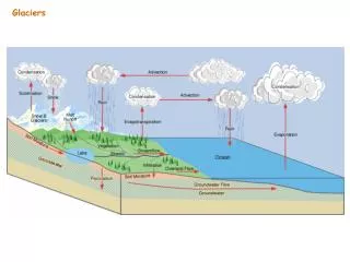
Glacial Ice Once glacial ice exceeds a thickness of about 150 feet, the weight of the overlying ice causes the base of the glacier to become plastic and flow like a very viscous liquid. While the bottom ice responds as a plastic solid, the surface ice is very brittle. However, from the surface down to the top of the plastic portion of the glacier, the ice experiences a decrease in brittleness. The result of the vertical variation in the brittleness of the upper ice is the formation of fractures that open upward called crevasses.
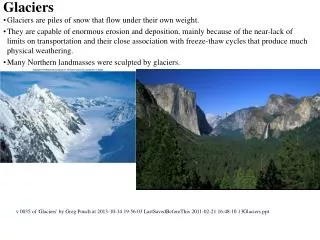
Glacial Erosion Glaciers erode by two processes, abrasion and plucking (called quarrying by some). As glaciers move, they pick up all loose rock material in their paths and incorporate it into the glacier’s base layer. This rock serves the same role of the grit on sandpaper as it abrades and grinds away the bedrock over which the glacier moves. Alpine glaciers are underlain by a thin layer of water created by the pressure melting of the ice bottom. This water penetrates fractures in the bedrock and refreezes, breaking up the rock in a process akin to frost wedging. Loose blocks of rock are then taken up into the ice and carried off. In the case of continental glaciers where the temperature at the base of the glacier is too cold to allow pressure melting, the ice freezes to the bedrock surface. Imagine your tongue stuck to a metal pipe in the winter. As the ice moves, it literally plucks away pieces due to the generated tensional forces. These blocks are eventually taken up into the ice.
Continental Ice On the scale of a continental glacier the surface over which it moves must be considered horizontal. An object resting on a horizontal surface can not move of its own accord, an outside force is required. In the case of continental glaciers, the horizontal force is generated within the ice itself when the ice at the center of the ice sheet collapses upon itself. This forces older ice to move out of the way of the collapsing new ice in exactly the same way as pancake batter poured onto the horizontal surface of a griddle moves toward the edges of the griddle. As additional batter is added, the “older” batter moves out of the way to allow the collapse of the batter newly added to the griddle. In the case of continental glaciers, the magnitude of the horizontal forces can be great enough to drive the ice sheet up and over fairly large obstacles. This is what happened when the ice sheet over-rode the Adirondack Mountains during the last Ice Age.
Tributary Glacier and Hanging Valleys Once alpine glaciers leave the cirque, they flow down the length of the stream valley in which they formed. As the ice flows, it changes the typical V-shape of a youthful mountain stream into the equally diagnostic U-shape of a glaciated valley. Much like streams, major alpine glaciers have tributaries. Sometimes these tributary ice flows are confined to smaller valleys that are higher in elevation than the main valley. When the ice recedes, these hanging valleys can be the location of spectacular waterfalls. Perhaps the most well known glacial valley in the United States is Yosemite Valley. Some of the most spectacular waterfalls within Yosemite Valley, such as Bridal Veil Falls, emerge from hanging valleys.
Alpine Weathering and Erosion Alpine glaciers are responsible for much of the scenic splendor seen in mountain ranges from the Rockies to the Alps to the Himalaya. The sculpting begins with glacial ice forming in the headwaters of mountain streams located on both sides of a mountain range. As the ice mass grows, it carves a bowl-shaped depression into the side of the mountain called a cirque. In time, cirques from adjacent valleys on both sides of the ridge begin to overlap forming a knife-edged mountain ridge called an arête. Where cirques from opposite sides of the ridge meet the overlying rock can collapse under its own weight forming a high mountain pass called a col. In another scenario multiple cirques form around a mountain peak and eventually create a sharp mountain spire called a horn. Perhaps the most well known horn is the Matterhorn in the Swiss Alps. However, one doesn’t have to go so far to see excellent examples of horns. The Grand Tetons of Wyoming are a series of glacially-formed horns.
Moraines At some physical location, the environment will dictate that the rate of ice movement is equal to the rate at which the glacial front melts. At this point and time the glacial mass has reached equilibrium ands stops its lateral motion. However, the ice within the mass never stops moving. As the ice moves to the snout (front of the glacier) all of the debris being carried in its base is piled up along the margin of the ice in the form of a ridge . A terminal moraine marks the glaciers furthest geographic advance. Retreating ice that stagnates for some period of time can created additional recessional moraines. Glacial meltwater forms torrential streams that pick up materials from the terminal moraine and carry them away from the terminus where they are deposited as outwash plains, in the case of continental glaciers, or valley trains, in the case of alpine glaciers. Being stream deposits, outwash plain and valley train deposits are well sorted in contrast to the poorly sorted till that makes up most glacial moraines. Click On Illustration For More… Lateral and Medial Moraines As alpine glaciers move down valleys the erosive power convert the original stream generated V-shaped valley into a diagnostic U-shaped cross section. Rock debris falling from the valley walls fall onto the margin of the ice. When the ice recedes, the accumulated debris remains. This evidence of glacial presence is called a lateral moraine. Where tributary valleys join the main valley, the deposits on the inside of the two tributaries coalesce to form a deposit of rock debris down the middle of the surface of the main glacier. When the ice melts, this material remains behind and is called a medial moraine. Only alpine glaciers can have lateral and medial moraines.
Identification of Multiple Episodes of Glaciation By recognizing two deposits of glacial till, ground moraine and a ridge of till, separated by a soil profile, Louis Agassiz was able to determine that the two deposits were of vastly different ages. The illustration shows his logic in simplified form. He was able to show that all of the features labeled “Ice Advance #1” were formed as the result of a single glacial event. He also realized that the soil covering the deposits of Ice Advance #1 must have taken thousands of years to develop. From this he presumed that the soil had developed during an inter-glacial period when the ice retreated. After an inter-glacial period the ice returned in the form of Ice Advance #2. This advance picked up Ice Advance #1 material it encountered. In the illustration, the second ice advance came to a stop before it had picked up all of the ground moraine of Ice Advance #1, leaving the remaining ground moraine and the terminal moraine from Ice Advance #1 intact. As it came to its terminus, Ice Advance #2 deposited a terminal moraine on top of the older ground moraine and soil. By observing the soil profile between the two moraines, Agassiz realized that the upper moraine was a terminal moraine and much younger than the underlying ground moraine. By making observations such as these throughout Europe, Agassiz was able to determine that the Great Ice Age did not consist of a single advance and retreat but rather four distinctly different ice advances separated by three inter-glacial periods.
Great Lakes Perhaps the most spectacular product of the Great Ice age in North America was their creation of the Great Lakes. While Lake Superior may have been a smaller lake before the coming of the ice, all the other lakes were carved from stream valleys by the advancing ice. This diagram provides some basic information about the Great Lakes including their relative locations, depths of water, and elevation above sealevel. Click On for Different View of Great Lakes
Niagara River Before the ice came the falls of the Niagara River were located at the Niagara Escarpment. Geology of Niagara Falls Niagara Falls is located between Lake Ontario and Lake Erie. When the ice of the last glacial episode began melting back from the region about 11,000 years ago, the falls were about eight miles downstream from their present location. During the intervening 11,000 years the falls have moved upstream as the Lockport Dolomite underlying the lip of the falls has been eroded. At present the falls are retreating at a rate of about 3 feet per year and will reach the riffle stage before they work their way back to Lake Erie.