Download
1 / 1
10 likes | 70 Views
University Beach Monitoring Project Deidre Williams, Division of Nearshore Research Conrad Blucher Institute for Surveying and Science, Texas A&M University-Corpus Christi.

E N D
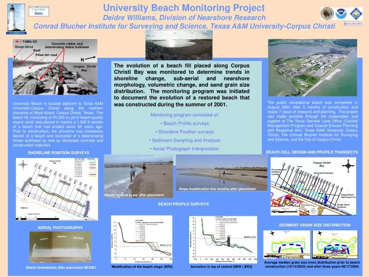
University Beach Monitoring ProjectDeidre Williams, Division of Nearshore ResearchConrad Blucher Institute for Surveying and Science, Texas A&M University-Corpus Christi The evolution of a beach fill placed along Corpus Christi Bay was monitored to determine trends in shoreline change, sub-aerial and nearshore morphology, volumetric change, and sand grain size distribution. The monitoring program was initiated to document the evolution of a restored beach that was constructed during the summer of 2001. Shoreline prior to beach construction. The public recreational beach was completed in August 2001 after 5 months of construction and nearly 7 years of research and planning. The project was made possible through the cooperation and support of The Texas General Land Office (Coastal Management Program and Coastal Erosion Planning and Response Act), Texas A&M University Corpus Christi, The Conrad Blucher Institute for Surveying and Science, and the City of Corpus Christi University Beach is located adjacent to Texas A&M University-Corpus Christi along the northern shoreline of Ward Island, Corpus Christi, Texas. The beach fill, consisting of 45,000 cu yd of beach-quality quarry sand, was placed to restore a 1,200 ft section of a beach that had eroded some 60 years ago. Prior to construction, the shoreline was completely devoid of a beach and consisted of a deteriorating timber bulkhead as well as discarded concrete and construction materials. • Monitoring program consisted of: • Beach Profile surveys • Shoreline Position surveys • Sediment Sampling and Analysis • Aerial Photograph Interpretation BEACH CELL DESIGN AND PROFILE TRANSECTS SHORELINE POSITION SURVEYS Slope modification five months after placement Nearly vertical scarp after placement BEACH PROFILE SURVEYS SEDIMENT GRAIN SIZE DISTRIBUTION AERIAL PHOTOGRAPHY Average median grain size (mm) distribution prior to beach construction (10/13/2003) and after three years 05/17/2004. Modification of the beach slope (BR4) Accretion in lee of central DBW ( BR3) Beach immediately after placement 08/2001