Download
1 / 45
450 likes | 574 Views
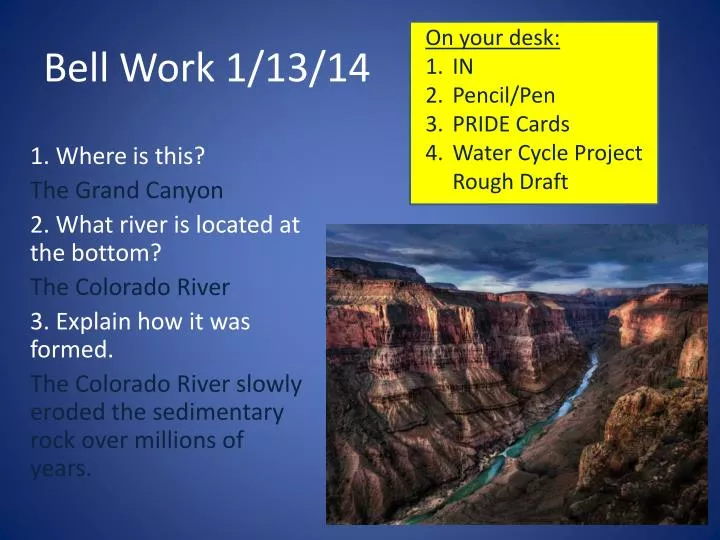
On your desk: IN Pencil/Pen PRIDE Cards Water Cycle Project Rough Draft. Bell Work 1/13/14. 1. Where is this? The Grand Canyon 2 . What river is located at the bottom? The Colorado River 3 . Explain how it was formed .

E N D
On your desk: • IN • Pencil/Pen • PRIDE Cards • Water Cycle Project Rough Draft Bell Work 1/13/14 1. Where is this? The Grand Canyon 2. What river is located at the bottom? The Colorado River 3. Explain how it was formed. The Colorado River slowly eroded the sedimentary rock over millions of years.
Chapter 1 Section 1 • Reading : http://my.hrw.com/tabnav/controller.jsp?isbn=0030490839 • Output Activity: Definition and Picture
Picture Vocabulary Word Definition Erosion
Picture Vocabulary Word Definition Erosion Water Cycle
Picture Vocabulary Word Definition Erosion Water Cycle Tributary
Picture Vocabulary Word Definition Erosion Water Cycle Tributary Watershed
Picture Vocabulary Word Definition Erosion Water Cycle Tributary Watershed Divide
Picture Vocabulary Word Definition Erosion Water Cycle Tributary Watershed Divide Channel
Picture Vocabulary Word Definition Erosion Water Cycle Tributary Watershed Divide Channel Load
On your desk: • IN • Pencil/Pen • PRIDE Cards Bell Work 1/14/14 • Double Bubble: Where is water stored on our planet?? Minimum of 15 bubbles!! FW SW 2. What percentage of all available water does SW make up? 3. What percentage of all available water does FW make up?
Freshwater Systems • 97% is ocean water. • Only 3% is freshwater. • 2% is locked up in glaciers and ice caps. • 1% is usable by humans • Groundwater • Rivers • lakes
Freshwater Storage • Glaciers- form where more snow falls than melts each year. • Ponds and Lakes- form in depressions(low areas) in the land. • Atmosphere- tiny % of earth’s water is found in the form of clouds.
Streams and Rivers • Tributaries- a stream that flows into a lake or into a larger stream. • Watershed- The area of land that is drained by a water system. • Also called drainage basins. • Divide- The boundary between drainage areas that have streams that flow in opposite directions.
ArizonaWatersheds • Upper Colorado River Basin • Verde River Basin • Salt River Basin • Little Colorado Basin
Stream Development • Streams erode paths through sediment and rock, forming V-shaped valleys. • But.... what affects stream formation and structure? How does the water want to flow? http://www.youtube.com/watch?feature=player_detailpage&v=ubP_-ptVDbY
Supply of Water • Stream formation relies on a consistent water supply • Precipitation • Underground deposits of water
Supply of Water • Moving water carves a narrow pathway into the sediment or rock called the stream channel. • Stream banks hold the moving water within them.
Velocity of stream • When a stream is straight the water has maximum velocity in the center of the channel • The water has minimum velocity on the sides and bottom of the channel WHY????
Meanders • A bend or curve in a stream channel is called a meander . • Water moving along the outside of a meander curve experiences the greatest velocity and erodes the side of the stream bed. • Water moving along the inside of the meander is slower and deposition is occuring. Erosion Deposition
Deposition • Delta- A fan-shaped mass of material deposited at the mouth of a stream.
Deposition • Alluvial Fan- A fan-shaped mass of material deposited by a stream when the slope of the land decreases sharply.
Floods • A flood occurs when water spills over the sides of the stream’s banks. • The flat area that is covered with water during times of flooding is called the floodplain.
Lakes • Natural lakes are bodies of water surrounded by land. • ZONES: • Littoral Zone- area closest to the shore. • Benthic Zone- lowest area of a body of water.
On your desk: • IN • Pencil/Pen • PRIDE Cards Bell Work 1/15/14 1. What is the difference between a delta and alluvial fan? • The elevation change of the stream to the ocean. 2. Describe how a meander is formed. Make sure to include velocity, erosion, and deposition. • Meanders are formed due to the movement of stream water. The greatest velocity is on the outside of the meander, which causes erosion. The lowest velocity occurs at the inside of the meander, where deposition occurs.
6th hour QUIZ!!
Groundwater The water located beneath the earth's surface in soil pore spaces and in the fractures of rock formations. Rock is either… Impermeable rock- a rock that water cannot flow through. Permeable rock- a rock that water can easily flow through.
Groundwater The majority of freshwater is found underground. • Water collects in spaces between particles of sediments underground.
Aquifers A layer of rock or sediment that stores groundwater. What type of rock makes a good aquifer? - sedimentary rock - many pores (open spaces) between sediments
Aquifers • Porosity- The fraction of a rock’s volume that is taken up by pores. • Permeability- A rocks ability to let water pass through.
Aquifer • Saturated zone- region where pore spaces are entirely filled with water. • Water table- top of the saturated zone.
How do we get to groundwater? • Well- A hole dug below the water table in order to access water. • Spring- The side of a hill intersects the water table and water flows out.
Video • HORIZON Eight • Arizona PBS-Water Sustainability • http://www.youtube.com/watch?v=OxC779Fjw1o • What are the three Rs? • Where does AZ get it’s water? (groundwater, surface water, and a little bit of reclaimed water.) • Why is Arizona fortunate as far as water supply? (We have alot of ground water, we have large rights to the CO River)