Download
1 / 65
661 likes | 829 Views
Atmospheric Circulations. Chapter 7. A Fluid Atmosphere. Easier to envision atmospheric motions if we think of our atmosphere as a fluid That’s what it really is Air motions are similar to those in any fluid Oceans, rivers, etc.

E N D
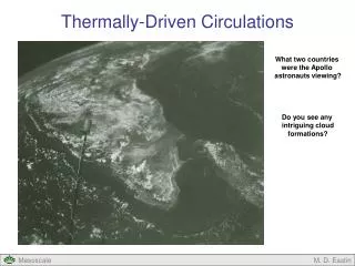
Atmospheric Circulations Chapter 7
A Fluid Atmosphere • Easier to envision atmospheric motions if we think of our atmosphere as a fluid • That’s what it really is • Air motions are similar to those in any fluid • Oceans, rivers, etc. • All kinds of circulations ranging from microscopic whirls to large storms (low pressure systems) to global wind patterns (jet streams)
Water vs Air “Eddies” Gulf Stream
Scales of Motion • In meteorology, scales of motion describe the size and duration of circulations • Smallest scale we’re concerned with is the microscale, largest is the global scale • And everything in between
Scales of Motion Global Synoptic Meso Micro
Scales of Motion • Often, it’s hard to tell what kind of motions are going on since you can’t see air • Can’t see turbulence in a plane right?
Scales of Motion • Sometimes you can see what’s going on when motions are visible in clouds
Local Wind Systems • Interesting topic because they exist almost everywhere • Coastal regions - Seabreezes • Mountains - Chinook winds, mountain/valley breezes • Often due to 1) terrain or 2) temperature differences from one place to another • If due to 2) - we call it a thermal circulation
Thermal Circulations • These circulations are due to differences in temperature • Like between air over land vs air over water • The temp differences cause something to happen to the pressure • And what happens when the pressure is different from place to place?? • WIND
Thermal Circulations • Initially, if temps are uniform, so are pressure surfaces • Going upward, pressure surfaces are horizontal • But what if air to the south heats up?
Thermal Circulations • Remember from earlier, if a column of air warms, it stretches vertically • So, the pressure surfaces are now higher in the warmer air causing a pressure gradient force - wind
Thermal Circulations • To the south, a “thermal low” pressure develops at the surface • Due to air moving toward north aloft • To the north, high pressure develops at surface • Due to air piling up aloft
Thermal Circulations • So, air begins to move from high to low at both the surface and aloft • Air at the surface warms near the low and rises • Air aloft cools over the surface high and sinks
Sea Breezes • Sea breezes are a good example of a thermal circulation • Form in tropical/sub-tropical regions in the warm season • People from coastal areas of FL know about these - nice at the beach but reeeaaall dark inland • Can also have “lake breezes” and “river breezes” which form in the same way
Sea Breezes • Same as before except now the water/land is causing the contrast in temp/pressure • Thermal low develops over land and wind at the surface moves from water to land
Sea Breezes • As before, air rises in the vicinity of the thermal low and often produces thunderstorms inland • That’s why the summer weather at the coast is usually better than weather inland (in terms of sunshine)
Sea Breezes-lightning T-storms East Coast Sea Breeze Sea Breeze in panhandle
Sea Breezes • How would you know that a sea breeze has passed? • Temp ? • Decreases (air off of the water is cooler) • Humidity ? • Increases (air off of the water is more moist) • Wind ? • Shifts to onshore and increases in speed • Sky ? • Clear after passage, cloudy before
Sea Breezes • Florida gets hit often by thunderstorms due to sea breezes • Sometimes sea breezes from both coasts converge over the central peninsula (Orlando in particular)
Sea Breezes • Which raises an interesting question……
Land Breezes • Remember from several weeks ago we said that land heats up and cools down quicker than water? • Happens at night causing a reversal of the sea breeze • Called a land breeze
Land Breezes • Air over land cools quickly at night • So now air over water is warmer than air over land • Winds switch to offshore • generally weaker than the sea breeze
Monsoon • What kind of image does that word conjure up? • Lots of heavy rain? • Floods? • Actually it means: • A seasonal shift in wind patterns • So it doesn’t directly address rain at all • The monsoon is a thermal circulation just like the sea breeze but it occurs as a seasonal cycle - not a daily cycle
Asian Monsoon • Asian monsoon is the most well developed one • Weaker monsoon over the desert southwest of N. America • Very cold air over the continent during winter • Causes high pressure and flow toward the water • This also keeps moisture offshore • So, very dry over land in the winter
Asian Monsoon • Things (winds) change during the summer as the land heats up and low pressure develops • Now wind moves onshore and brings with it very moist air • This region, particularly central India, gets absolutely hammered w/ rain • Some places over 400 inches a year! (most of it coming in 6-7 months!)
Asian Monsoon • Why so much rain (other than the obvious)? • 1) Convergence of air enhances upward motion • 2) Terrain Lots of mountains
Chinook Winds • “Snow eaters” • Warm, dry winds on the eastern side of the Rocky Mountains • Due to compressional heating as air descends • Enhanced if clouds form on the western side • Can cause warming of >40ºF in 1 hour!
Chinook Winds • “Chinook wall cloud” - precursor of Chinook winds • 20ºF when this pic was taken - 60ºF same time next day
Chinook Winds • How they work • Any air which descends will warm by compression - compressional heating • main source of warmth for Chinooks • But if clouds form on the western side of the mountains, the Chinook wind will be even warmer and drier than w/o clouds • Why? • Have to go back to the moist/dry adiabatic stuff • Remember: moist rate=6ºC/1000m, dry rate=10ºC/1000m
Chinook Winds • Air which starts at 10ºC on the western side, ends up at 18ºC on the eastern side. • Due to cooling at the moist rate starting at 1000 m…..but warming at the dry rate going down • So, clouds enhance the Chinook winds Cooling at moist rate Warming at dry rate
Chinook Winds • Very localized - just near the mountain base • As warm air hits the cold air below, the boundary can oscillate • Cities near the boundary can experience rapid back-and-forth changes in temperature
Chinook Winds • One case in South Dakota: • 5:30 a.m. : -4ºF • 9:40 a.m. : 54ºF • 10:30 a.m.: 11ºF • 10:45 a.m.: 55ºF
General Circulation • From earlier, there are all kinds of local wind systems - many more than I went over • All kinds of smaller circulations too • But what about the global wind patterns? • If we average winds over a long period of time, the small stuff disappears and we are left with the “global scale winds” or “general circulation” of the atmosphere • Keep in mind - just an average • Can be different at any particular instant
General Circulation • A look at the average global winds can give us insight into • 1) Driving mechanisms behind the winds • 2) Model of how heat is transferred from the tropics to the poles • Already established the fact that uneven heating of the earth is what causes weather • Including wind • In a nutshell: tropics get excess energy while polar regions have an energy deficit • Wind tries to balance things
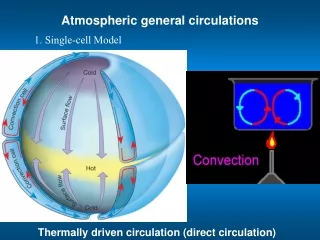
Single Cell Model • Very simplified model but still gives us some insight. 3 Key assumptions: • 1) All water over the earth • 2) Sun always over equator • 3) No rotation • Result: • High pressure at the poles • Low pressure at the equator • 1 huge convective cell in each hemisphere • Called “Hadley Cells” after the guy who postulated the idea.
Single Cell Model • Cold air flows toward tropics from poles (H to L) at the surface • Warm air flows toward poles from tropics aloft • Just like a sea breeze circulation • So, some of the excess energy at the tropics is transferred to the poles • What if we get rid of assumption #3 and let the earth rotate?
Three Cell Model • Now we have 3 cells in each hemisphere rather than one. • More realistic • Still have H pressure at poles and L pressure at equator • Also now, H and L pressure at 30º and 60º respectively H L H L H L H
Three Cell Model • Look at the vertical motion where the cells meet: • Equator: Rising air • Lots of rain here • 30º: Sinking air • Most of the world’s deserts lie near this latitude • 60º: Rising air • This is where most big mid-latitude storms form • So this model does a better job with surface winds
Three Cell Model • Not too bad huh? • Everything is shifted to the south due to seasons • Cloud bands where the model says low pressure should be • Rising air Today
Surface Winds • Intertropical Convergence Zone (ITCZ) • near the equator • tropical systems form here • Trade winds • named such because sailing vessels used these winds to travel west • not much wind poleward of the trades (horse latitudes) • Westerlies • where we live • Polar Easterlies
The Real World • Still two assumptions in the three cell model • all water/no land and sun always over equator • These factors change things a bit and give us the real pressure/wind fields…….
The Real World • Semi-permanent features • Lows near 60º • Highs near 30º January
The Real World • Strength and position of these features changes with the seasons • The Highs on either side of the U.S. have a great impact on weather at each coast July
Semi-permanent Highs • Generally sinking air on the east side of highs and rising air on the west side • Summers are dry on the west coast and wet on the east coast
Semi-permanent Highs • LA (west coast) gets almost no rain during the summer • Atlanta (east) gets a great deal of rain during the summer months
Jet Streams • Fast flowing “rivers” of air at upper levels • 33,000-46,000 ft usually • On average: 100’s - 1000’s miles long, 100 miles wide, 1 mile deep • Existence first confirmed by military pilots during WWII • Suspected beforehand due to fast moving cirrus clouds • Important because they can show us where cold air is and where storms will track • Also if storms will intensify
Jet Streams • Like all winds, jets occur due to horizontal differences in pressure • Sharp north/south temperature/pressure differences aloft • The temperature contrast is at a maximum during the winter • Jet streams are strongest during winter season