Download
1 / 1
10 likes | 117 Views
Noteworthy North American Tornado Outbreaks. Hook echoes (arrows) on Cincinnati WSR-57 radar at c. 5:45 p.m. EDT (NOAA and Steve Horstmeyer). Tracks and estimated intensities (F scale) of the 31 May 1985 tornadoes (After Fujita) . (1) The “Enigma Outbreak,” Mississippi to Virginia,

E N D
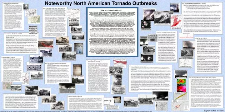
Noteworthy North American Tornado Outbreaks Hook echoes (arrows) on Cincinnati WSR-57 radar at c. 5:45 p.m. EDT (NOAA and Steve Horstmeyer) Tracks and estimated intensities (F scale) of the 31 May 1985 tornadoes (After Fujita) (1) The “Enigma Outbreak,” Mississippi to Virginia, 19 February 1884 This event, sometimes known as the Great Tornado Outbreak of February 19, 1884, was named the “Enigma Outbreak” by Joseph Galway because of the wide variation in reported death toll. The outbreak appears to have been associated with a significant jet stream disturbance and surface low, similar to those present during the 1974 “Super Outbreak” (Event #11). While also similar in areal extent to the Super Outbreak, the Enigma Outbreak occurred mainly south of the Ohio River. The event began during the late morning in Mississippi and Alabama, spread rapidly east-northeast into Georgia and the Carolinas during the afternoon, and reached Virginia at night. An additional swath of tornadoes and other forms of damaging wind occurred from southeast Missouri and southern Illinois into southern Indiana, Kentucky, and Tennessee. At least one of the tornadic thunderstorms continued east into the Atlantic, where a waterspout seriously damaged the schooner “Three Sisters” off the coast of Charleston, South Carolina. Noted U.S. Signal Corps tornado researcher John P. Finley (right) provides details on a total of 44 individual tornadoes in the event in his 1885 Tornado Studies for 1884. A later estimate by Finley (that has been repeated elsewhere) lists 60. In light of apparently comparable events in more recent decades, it seems that many tornadoes likely went unreported, especially in the more remote parts of the Appalachians. While most of the tornadoes remained in rural areas, the towns of Leeds, Alabama (east of Birmingham) and Columbus, Georgia were hit. The Monthly Weather Review described Leeds as being a scene of “great destruction” and that, of homes struck by the tornado, “not even their foundations remained.” Contemporary accounts of the outbreak list as many as 370 deaths, including 200 in Georgia and 80 in South Carolina. These figures were based on telegraphic reports to newspapers from towns and villages along railroad lines; fatalities that may have occurred elsewhere likely were not reported. Many of the deaths included freed slaves living in isolated rural communities. Rumors spread that more than 2000 people had died. In 1887, Finley placed the total loss of life at 800, the number of injuries at 2500, and the number left homeless at 15,000. Finley did not indicate how he arrived at these values, but given his experience in documenting tornadoes, his estimates must be considered seriously. If correct, the 800 deaths would make 19 February 1884 the single deadliest tornado day in recorded history in the United States. (11) The “Super Outbreak,” Midwest, Ohio Valley, and South, 3 – 4 April 1974 The Super Outbreak of tornadoes of 3-4 April 1974 remains the most outstanding severe convective weather episode of record. Although not the most deadly outbreak, the event surpassed previous and succeeding events in severity, longevity, and extent. The following statistics only partly convey its enormity: 148 tornadoes, 95 of which were F2 or stronger, 30 of which were “violent” (F4 or F5), and 48 of which were killers Combined path length of tornadoes at least 2500 miles; one tornado with path length >100 miles One or more F2 or stronger tornadoes in progress during each three-hour period between midday 3 April and early morning 4 April; fifteen tornadoes in progress simultaneously at height of the outbreak 335 deaths; more than 6000 injured Tornadoes occurred in thirteen states and Canada; ten states declared federal disaster areas Further appreciation for the enormity of the Super Outbreak may be gleaned from the graph at the lower left corner of this panel. The graph, courtesy of Harold Brooks, depicts the maximum annual week-long running total of F2 or greater tornadoes from 1921 through 2011. Entire years that are noted for their prominent tornado counts (e.g. 1953, 2003, and 2011) pale in comparison to the 18-hour period that began around midday on Wednesday, 3 April 1974. Twenty-five F3 or greater long-track tornadoes (those with path lengths > 25 miles) occurred during the same period, more than triple the number annually reported since 1880. The first tornado in the Super Outbreak touched down near Morris, Illinois (about 45 miles southwest of Chicago) around 2:15 p.m. CDT, producing minimal damage; the last one overturned trailers and removed roofs in Baton, North Carolina (about 65 miles east of Asheville) at 7:00 a.m. EDT the next morning. Between these two events, three separate waves of tornadic storms spread havoc from southern Michigan and southern Ontario south and southeast through Illinois, Indiana, and Ohio to the Gulf Coast states, Georgia, the Carolinas, and Virginia. The most intense tornadoes avoided the cores of major cities in the region. But portions of metropolitan Birmingham, Cincinnati, Louisville, and Windsor (Ontario) were hard-hit. An F5 storm leveled a large part of Xenia, Ohio (southeast of Dayton) during the late afternoon, killing at least 30 people. Similar tornadoes struck the towns of Brandenburg, Kentucky (southwest of Louisville), and Guin, Alabama (northwest of Birmingham); both communities lost about two percent of their residents to the storms. A vicious, one-half mile wide tornado cut a swath more than 100 miles long in northern Indiana and destroyed the county courthouse in Monticello. Farther south, a pair of violent, long-lived tornadoes tore through northern Alabama during the early evening. They partly followed nearly identical paths, both of which extended at least 50 miles and together claimed 50 lives. One man, injured by the first storm, was killed when the church to which he had been taken was hit by the second storm a half-hour later. Long-track tornadoes travelled up and down mountainsides in the southern Appalachians through the night, dispelling the notions that tornadoes are disrupted by rough terrain and that the worst storms occur during the warmest time of the day. The Super Outbreak was well-forecast. Nearly every tornado and severe weather report was contained within the severe weather outlook issued by the National Severe Storms Forecast Center (NSSFC; predecessor to the Storm Prediction Center) early on the morning of 3 April. Most of the deaths occurred in valid tornado watches, and most of the tornadoes also were preceded by warnings. The large death toll, however, illustrated that the nation’s warning system is of limited value when storms are numerous, intense, and fast-moving. Warning dissemination was hampered by over-taxed teletype communication lines and, especially, by delays that occurred at relay points between intrastate warning circuits. To address these issues, the National Weather Service (formerly, the Weather Bureau) survey team assembled after the event recommended accelerated deployment of the Service’s planned automated internal communication system, later known as AFOS. The team also suggested expansion of the then-fledgling NOAA Weather Radio network to facilitate warning dissemination. Weather radio proved valuable for rapid and efficient communication of storm information in those cities where the system already was in operation (Atlanta, Detroit, Indianapolis, and St. Louis). As with the Palm Sunday Outbreak (Event #10), University of Chicago researcher T. Theodore Fujita and his associates conducted a comprehensive investigation of the Super Outbreak immediately following the event, documenting tornado tracks and intensities with aerial photography. In addition to documenting the destruction caused by the tornadoes themselves, his efforts helped clarify the role played by thunderstorm downburst winds. These localized bursts of high wind often occur near tornadoes, enlarging storm damage swaths. Fujita’s findings also confirmed that similar bursts of wind in the absence of tornadoes had caused several significant airplane mishaps in the mid 1970s. Building on his work with the Palm Sunday event, Fujita’s Super Outbreak studies also further demonstrated how suction vortices, small scale circulations within a tornado, produce the narrow corridors of significantly enhanced damage often observed. Tornado approaching Sayler Park, Ohio around 5:00 p.m. EDT z (5) The “Tri-State Tornado,” Missouri – Illinois – Indiana, 18 March 1925 The single, most devastating tornado in United States history, the “Tri-State Tornado” of Missouri, Illinois, and Indiana, was part of an outbreak of only eight documented tornadoes on the fateful afternoon of Wednesday, 18 March 1925. But the event remains the nation’s deadliest, and the Tri-State Tornado continues to hold the record for being the longest, single, continuous-track tornado (219 miles). The Tri-State Tornado began around 1 p.m. local time near the town of Ellington in southeast Missouri. Accompanied by a series of damaging downbursts and, at times, multiple funnel clouds, the storm raced east-northeast along an unwavering path for another 180 miles through the remainder of southeast Missouri and southern Illinois with an average speed of 62 miles per hour. The tornado turned slightly more north of east as it entered southwest Indiana around 4 p.m. but did not dissipate until moving beyond the town of Princeton one-half hour later (see map at right). Averaging three-quarters of a mile wide for much of its existence, the storm devastated everything in its path. The towns of Annapolis, Missouri, Gorham and Parrish, Illinois, and Griffin, Indiana were completely destroyed or nearly so. The storm blasted through Murphysboro, Illinois, killing 234 ― a figure that remains the largest single-city tornado death toll in the United States. The storm’s unusual appearance during much of its existence ― it was described as being a mass of boiling, black fog ― and its rapid speed of movement ― likely contributed to the great death toll. Overall, the tornado claimed nearly 700 lives, injured 2000 others, and produced damage on the order of $17 million (1925 dollars). It lasted more than three hours. The Tri-State Tornado’s intensity and long life suggest that unique meteorological conditions likely contributed to its singular nature. An early study, for example, theorized that the tornado was nearly directly associated with an usually deep synoptic-scale surface low. This idea, however, has been challenged more recently by a team of researchers that includes Storm Prediction Center forecasters John A. Hart and Robert H. Johns (retired). This group undertook a detailed analysis of the event. They concluded that while the supercell responsible for the Tri-State tornado did indeed form near the center of a low in Missouri, the low was not unusually strong, and that the storm outpaced the low’s motion. As a result, the tornadic storm was located well ahead of the low as it crossed Illinois and Indiana. What was unique about the situation, it appears, is that the supercell moved in tandem with an advancing “sweet spot” for tornado production located near the intersection of the low’s advancing warm front and dry line. This motion enabled the storm to remain in a favorable environment for strong tornado production for several hours. Their work also suggests that the Tri-State devastation was indeed the work of a single tornado rather than a series of related tornadoes; its 219 mile path length remains unchallenged to this day. The other documented tornadoes on this date also produced deaths. In particular, a late afternoon storm in Kentucky and Tennessee killed 39. Altogether, 748 people died from tornadoes on 18 March 1925 – one of the single deadliest tornado days ever. Evidence suggests that additional tornadoes likely occurred that day, but only those that caused deaths were recorded due to the overwhelming nature of the Tri-State storm. What is a Tornado Outbreak? Despite its frequent use, no universally accepted definition exists for the phrase “tornado outbreak.” The Merriam-Webster dictionary defines an “outbreak” as “a sudden or violent increase in activity.” But this definition is of little value when applied to infrequent events such as tornadoes. What is meant by “sudden”? How many observed tornadoes constitute an event? Outbreaks also are not associated with a singular atmospheric state; many different weather patterns and combinations or distributions of meteorological variables may, on occasion, result in an outbreak. In a 1977 Monthly Weather Review paper on tornadoes, veteran severe weather forecaster Joseph G. Galway defined an outbreak as the occurrence of ten or more tornadoes with the same synoptic scale weather system. This figure was double the number of events used to identify outbreaks at the joint National Severe Storms Forecast Center / Military Weather Warning Center in the 1950s and 1960s, and likely reflected the increased number of tornadoes that were reported in the 1970s relative to previous decades. Vastly improved tornado observing and reporting procedures since that time and, especially, the increased documentation of weaker events have inspired even higher thresholds and more elaborate definitions. For example, one recent study employed sophisticated statistical methods to objectively identify outbreaks based on the degree of spatial and temporal scatter present in a given set of tornado reports. While such objective efforts are laudable, a truly robust definition arguably should account for regional variations in tornado climatology. Four tornadoes on a single day might be considered a significant event in Maine, but barely gain notice in Kansas. Despite the lack of a formal definition, cases of “multiple tornadoes in the same general area” may be ranked in many ways. For example, the total number of tornadoes, the total tornado track length, or the total area affected may be compared. Other metrics include the number of “significant” (EF2 or greater intensity) or “violent” (EF4 or greater intensity) tornadoes, the number of killer tornadoes, the number of reported deaths or injuries, and the total dollar damage incurred. But each of these has limitations. Tornado intensity, for example, may be estimated only if the storm produces visible damage to structures or to exposed objects such as trees or pavement; tornadoes that remain over open areas are rated as being of either “weak” or unknown strength. And, as already noted, tornado reporting standards have changed over time. Prior to 1950, most tornadoes went unrecorded if they caused no damage or injury. In short, because of the imperfect nature of the tornado data base, no single criterion may be used to completely describe the impact of a given tornado. Likewise, it is impossible to be completely objective in ranking collective tornado events, i.e., “outbreaks.” The tornado outbreaks in this display are those believed to be the most deadly, damaging, prolific, and widespread overall, as judged subjectively from available records. Only events that occurred within a 24-hour period were included to eliminate multi-day tornadic episodes of comparatively lesser intensity. Each case also is notable because of one or more distinguishing factors mentioned in the descriptions. The outbreaks are numbered and arranged by date, with the oldest at the top left, and the most recent at the lower right. No attempt has been made to rank them, as demographic and tornado documentation trends invariably inflate the apparent significance of recent outbreaks relative to older ones. Impressive as they are, these events represent but a small fraction of the total number of significant tornadoes that have occurred in the United States since the first systematic efforts to document tornadoes were made in the late 1800s. This reflects the fact that significant tornadoes often occur outside major outbreaks ― and that major outbreaks are rare. Perhaps surprising is that most of the events identified occurred east of the Mississippi River, outside the so-called “Tornado Alley” of the Great Plains. While the average incidence of tornadoes is greater over the Plains relative to other parts of the country, the most damaging, deadly, and otherwise noteworthy tornado outbreaks tend to occur farther east and south. It is over the lower Mississippi, Ohio, and Tennessee Valleys that the meteorological ingredients favorable for long-lived, fast-moving tornadic thunderstorms ― and climatological factors such as the time of day and the time of year of greatest tornado incidence ― most often conspire with sociological factors including population density, shelter availability, and wealth to yield particularly widespread, destructive, and deadly events. John Park Finley 1854 - 1943 F5 tornado entering Sayler Park, Ohio (near Cincinnati) around 5:05 p.m. EDT (Horstmeyer) Tornado tracks, as mapped by John Park Finley in 1887 1 2 1 3 2 Surface weather map, 7 a.m. 19 February 1884 NOAA – ATS satellite view at 5 p.m. EDT, showing large, spiral-shaped cyclone centered over Iowa, and the three bands of supercell thunderstorms responsible for the outbreak 3 Tornado tracks of Super Outbreak; shading corresponds to the three squall lines shown in satellite image (After Fujita) (9) Great Lakes / New England (Flint, Michigan and Worcester, Massachusetts), 8 – 9 June 1953 An unusually strong late spring weather system that moved rapidly east-northeast from the Mississippi Valley and Great Lakes into New England provided the background environment for what culminated in the most costly tornado to that time in the United States, the infamous Worcester, Massachusetts storm of 9 June 1953. The weather system, responsible for numerous significant tornadoes over Nebraska and Iowa on Sunday, 7 June, produced a similar outbreak over Michigan and northern Ohio the following evening. The most notorious tornado of that event was an intense, half-mile wide F5 that struck Flint, Michigan shortly before sunset. The tornado raced east across the north side of town, leveling everything in its path and killing 115. Until the Joplin, Missouri tornado of 22 May 2011, this was the most recent, single tornado to claim more than 100 lives. Shortly before the Flint tornado, a separate storm produced an intense tornado over Monroe County, Michigan, in the southeast corner of the state. The storm hurled large trucks and other vehicles off U.S. Route 24 and continued east across Lake Erie for another 30 miles as a waterspout, establishing one of the longest such tracks on record. Farther south, an F4 tornado killed eight in Ohio. Monday, 9 June 1953, dawned relatively cool and cloudy over central Massachusetts, with little to suggest what would occur later in the day as a warm front advanced rapidly east across southern New England. In the windy, warm, and humid air behind the front, thunderstorms formed during the early afternoon over eastern New York. These matured into strong supercells as they reached the Berkshire Mountains of western Massachusetts later in the day. One of the storms spawned a tornado near Quabbin Reservoir (northeast of Springfield) around 4:30 p.m. local time that subsequently grew into a mile wide vortex. The tornado devastated parts of Holden, Shrewsbury, and Worcester as it followed a 46 mile-long east-southeast path to the western suburbs of Boston. The “Worcester tornado,” described as being a “huge cone of black smoke,” claimed 94 lives, injured nearly 1300, and left 10,000 homeless. The powerful storm destroyed or seriously damaged at least 4000 buildings, including well-constructed factories and schools, and those on the campus of Assumption College in Worcester. It lofted a tremendous amount of debris. The parent thunderstorm carried some of this material eastward to the Atlantic Ocean, well beyond the tornado’s demise near Sudbury Reservoir. A music box, an aluminum trap door, and a two-foot square piece of roof were among the items recovered after the storm passed near the Blue Hill Observatory, just south of Boston. Total damage due to the Worcester tornado was estimated at $52,143,000 (1953 dollars). The Worcester storm was the only killer tornado of three that occurred that afternoon in Massachusetts and southern New Hampshire. Man sifting through tornado debris at unspecified location in Illinois (Chicago Hist. Soc.; Chicago DailyNews collection) (2) St. Louis, Missouri – Illinois Tornadoes, 27 May 1896 An intense, long-lived, late afternoon tornado cut a swath of death and destruction up to a mile wide across the south side of St. Louis, Missouri and East St. Louis, Illinois on Wednesday, 27 May 1896. The storm became the nation’s most costly to date ($13,000,000 in 1896 dollars), but was just one of at least 17 other tornadoes that occurred in eastern Missouri and Illinois that day, some of which also were killers. The tornadoes culminated an intermittent series of outbreaks that had plagued parts of the central and southern states since 15 May. The St. Louis tornado began on the southwest side of the city near the Missouri Botanical Gardens (see panoramic view at right). It significantly damaged mansions in the Compton Heights area before widening and continuing through Lafayette Park and Mill Creek Valley to level countless smaller dwellings. Thousands were rendered homeless. At the Mississippi River, the storm swept steamboats and other craft off the river, smashing them onto the Illinois side. The tornado tore away three hundred feet of masonry on the east end of the Eads Bridge and blew freight cars off the bridge’s tracks. It then lay to waste brick and stone business buildings and thousands of frame houses in East St. Louis as people went home for the evening. Personal property was found deposited 70 miles away in Vandalia, Illinois. Open wire communication and electrical lines in both St. Louis and East St. Louis were left a tangled mess. The resulting sparks triggered numerous fires, some of which grew very large. Street car transportation was brought to a standstill. Up to three inches of rain added to the disaster later that night. Death tolls have varied for the outbreak. While the confirmed figure for the St. Louis storm is around 255 (137 in St. Louis and 118 in East St. Louis), given the extreme nature of the continuous swath of destroyed homes, schools, factories, and businesses, the unknown numbers who were severely injured and subsequently died, and those who perished aboard river craft on the Mississippi, the toll likely was much greater. Other tornadoes killed at least nine in Audrain, Montgomery, and Osage Counties in Missouri, and 41 in Clinton, Jefferson, St. Clair, and Washington Counties in southern Illinois. The St. Louis tornado was one of the first to strike a major city dependent on the modern conveniences provided by telephone and electricity. The disruption of these services seriously hampered rescue and clean-up efforts. In addition to the human and structural toll, the event also was noteworthy for yielding one of the few actual measurements to date of the extreme pressure reduction that occurs with the passage of a tornado. A home barometer near Lafayette Park recorded a pressure drop of 2.41 inches (82 mb) to a level of 26.94 inches (912 mb), as the storm passed. This represents a drop of nearly ten percent from normal sea level pressure. The 27 May 1896 outbreak also was unique in that it appears to have been associated with northwesterly wind flow in the mid troposphere. Mid-level winds more commonly are southwesterly during significant tornado outbreaks in the mid Mississippi Valley. Violent tornado near Toledo that killed five people near the town of Cygnet, Ohio (S. Sabol and D. Goddard) (12) Lower Great Lakes, 31 May 1985 A concentrated outbreak of violent, long-track tornadoes struck parts of Ohio, Pennsylvania, New York, and Ontario on the afternoon and evening of Friday, 31 May 1985. The event was the worst in recorded history over the lower Great Lakes, with ten F4 or F5 tornadoes and more than two dozen others that claimed 88 lives and left more than 1000 injured. Property damage in the United States alone totaled $450 million (1985 dollars). The outbreak was associated with a vigorous jet stream disturbance similar to the one responsible for the Great Lakes / New England outbreak of June 1953 (Event #9). Much of the affected area remained storm-free until an arc of intense supercell thunderstorms erupted rather suddenly from southern Ontario through western New York into central Ohio during the mid to late afternoon (see satellite image at left). Such powerful and rapid storm development, uncharacteristic of the East, is more typical of severe weather episodes over the Plains. It reflected the presence of a layer of warm air aloft that acted as a “lid” to prevent storm development earlier in the day. The warm layer originated over the Rockies and Plateau and was carried eastward well beyond its usual range by unusually fast jet stream winds. In Canada, the outbreak began around 3:00 p.m. EDT with a tornado that destroyed a barn and outbuildings near Georgian Bay in southern Ontario. About an hour later, a series of tornadoes affected areas farther south and east. The worst of these hit the town of Barrie, killing eight people and destroying numerous homes and warehouses. Around the same time, other tornadoes struck the region just north of Toronto. In the United States, a 4½ hour onslaught of violent weather began around 5:00 p.m. in northeast Ohio, not long after the explosive development of the first supercell storm there. The severe weather subsequently spread east across the northern half of Pennsylvania and into southwest New York. The first tornado in the United States touched down in far northeast Ohio around 5:00 p.m., destroying mobile homes and trees near Monroe Center. The circulation produced F4 damage as it continued east into Pennsylvania and struck the town of Albion, killing nine people. Around the same time, a similar tornado formed twenty miles to the south. That F4 storm moved east across northwestern Pennsylvania for more than 50 miles, striking the towns of Atlantic, Cooperstown, and Jamestown. Five people died in Atlantic, where a factory and grain mill were destroyed. Nearly simultaneously, another F4 storm tracked for more than 25 miles through mainly rural areas along the Pennsylvania-New York border. The most destructive tornado of the outbreak began about one hour later near Charlestown, Ohio (east of Akron). This F5 had a path length of nearly 50 miles and largely destroyed the town of Newton Falls as well as parts of Niles and Hubbard (both near Youngstown), where hundreds of homes were leveled. The storm entered Pennsylvania near the town of Wheatland. Ninety-five percent of Wheatland’s industries were lost, and a nearby aircraft hangar was hit. A plane wing lofted at the site was carried for ten miles to the town of Mercer. Still farther east, yet another violent tornado touched down around 7:30 p.m. near Penfield, Pennsylvania (east of Dubois). Although this long-lived vortex attained a path width of more than two miles and remained on the ground for nearly 70 miles, it fortunately tracked mainly through a state forest, thereby sparing life and property. The last F4 of the day occurred around 9:30 p.m. near Williamsport, Pennsylvania. Pennsylvania’s 65 fatalities during a four-hour period on the evening of 31 May 1985 nearly equaled the total number of fatalities (69) that had been reported in that state to date. Prior to 1985, only two tornado deaths had occurred in Pennsylvania in May. Eleven deaths occurred in Ohio, nearly as many (14) as had ever been recorded due to tornadoes in that state in May. Although several smaller communities were directly hit, the storms avoided larger population centers such as Akron, Erie, and Pittsburgh. The high death toll of the 31 May 1985 outbreak in spite of this fact reflects the outstanding number of intense tornadoes that occurred in a climatologically unfavorable region. Damage at unspecified location in Illinois (Chicago Hist. Soc.; Chicago DailyNews coll.) Damaged structure in Murphysboro (Jackson County, Illinois Historical Society) 1896 panoramic view of St. Louis by Charles Juehne, with tornado path to the Eads Bridge (U.S. Library of Congress) F5 tornado just before it struck Village Plaza (foreground), Niles, Ohio (Mike Zuharak) Logan School, Murphysboro, where five students died (Jackson County, Illinois Historical Society) Senator John F. Kennedy and local residents touring damage on Uncatena Ave, Worcester (The Worcester Telegram and Gazette) Eads Bridge, East St. Louis (Strauss; NOAA) (3) Louisiana to Georgia, 24 – 25 April 1908 The Louisiana – Georgia outbreak of 1908 was one of the nation’s deadliest. It claimed at least 324 lives and included the eighth-deadliest individual tornado. That tornado began near the community of Weiss, Louisiana (near Baton Rouge) during the late morning of Friday, 24 April 1908. The long-track storm continued nearly 160 miles east-northeast into Wayne County, Mississippi (south of Meridian), where it dissipated shortly after 3:00 p.m. local time. The most significant damage occurred in Amite, Louisiana, where the tornado reportedly attained a maximum path width of two and one-half miles and killed 29 people. After crossing into Mississippi, the storm destroyed the small town of Purvis, where 50 people perished. Altogether the tornado was responsible for 143 deaths and nearly 800 injuries. Other tornadic storms formed over Mississippi and Alabama during the remainder of the afternoon and evening. The activity reached western Georgia by early evening and continued over much of that state through early the following day. One of the Alabama storms carried a nine-ton tank one-half mile near Albertville (southeast of Huntsville), and nearly completely destroyed the town of Bergens (near Birmingham). The other noteworthy aspect of this event according to Galway was that it helped revive interest in the documentation of tornado outbreaks. In 1890 the U.S. Weather Bureau (predecessor of the National Weather Service) was transferred from the U.S. Army Signal Corps to the U.S. Department of Agriculture. Perhaps partly as a result of this change, tornado documentation became a very low priority in the 1890s and early 1900s. In fact, no organized records of tornadoes were made between 1897 and 1907, despite a memo by Bureau Chief Willis L. Moore following the St. Louis outbreak of 1896 (Event #2) that urged local offices to maintain accurate records of tornado occurrences. Newspapers and other sources reveal that during this period tornadoes nevertheless remained as common as ever. In fact, 1908 marked the beginning of a thirty year period of increased tornadic activity. In 1909 there were 76 killer storms, a record never since exceeded. The following year (1910) became the second consecutive year with more than 400 deaths. Nevertheless, it was not until 1916 that the Bureau resumed official documentation of tornadoes. Of course, because tornadoes were not yet forecast, there remained no overwhelming reason (i.e., forecast verification) to prioritize the effort, and only a small percentage of events were recorded. Arc of intense supercell storms extending from Toronto to Columbus, as seen by NOAA-GOES satellite at 7 p.m. EDT Typical scene in residential area of Murphysboro (Jackson County, Illinois Historical Society) Tornado paths through Gainesville, Georgia (J. Kincer, U.S.W.B., Mon. Wea. Rev., May 1936) (7) Tennessee Valley to North Georgia (Tupelo, Mississippi and Gainesville, Georgia), 5 - 6 April 1936 Two series of disastrous storms struck the southeastern states during the first week of April 1936. The first sequence claimed nearly four dozen lives from central Georgia into central North Carolina on 1-2 April. A tornado at Greensboro, North Carolina that killed 13 people and wrecked nearly 300 buildings was the most destructive to date in that state. Four days later, on 5-6 April, a more powerful and widespread outbreak occurred from northern Mississippi and southern Tennessee into north Georgia and upstate South Carolina. This event remains the second deadliest on record, with at least 450 killed and approximately 2500 injured. The first tornadoes struck northeast Arkansas on the afternoon of Sunday, 5 April, with one person killed in La Crosse. However, the outbreak began in earnest during the early evening over middle Tennessee, where at least three tornadoes occurred. One of these was an F4 that killed six people and cut a 35-mile path through Hardin, Wayne, and Lewis Counties. Around the same time, a separate area of tornadic storms formed in northeast Mississippi, yielding eight fatalities in Booneville and Coffeyville. The storm that produced the Coffeyville tornado moved rapidly northeast and subsequently produced a more massive tornado in Tupelo. The Tupelo tornado touched down in the western suburbs around 9 p.m. local time and moved east-northeast through residential areas on the north side of the city, missing the central business district. Nevertheless, the powerful storm with a path at least one-half mile wide leveled more than 200 homes and killed entire families. While the official death toll was 216, it appears that some listed as “seriously injured” when the figure was announced later died. A temporary hospital was set up in a movie theatre, and 150 railroad box cars were brought into town to house the homeless. The weather system responsible for the Mississippi and Tennessee storms continued east later that night, producing other killer tornadoes and damaging wind events in northern Alabama. The severe weather somewhat abated during the early morning of Monday, 6 April, only to resume with a vengeance after dawn over northeast Georgia. There, the greatest disaster of the entire outbreak occurred in the city of Gainesville. Around 8:30 a.m., a small tornado touched down on the north side of town, downing trees and damaging buildings on the campus of Brenau College before continuing east into the countryside. About ten minutes later, a pair of far more violent tornadoes entered the west side of Gainesville and tracked directly through the heart of the city at the beginning of the work day. The funnels merged near Public Square (see map, upper right) and cut a swath of death and near complete destruction four blocks wide that continued to the east edge of town. Hundreds of homes were demolished and several multi-story buildings collapsed. Some of the buildings subsequently caught fire, trapping victims inside. Seventy people alone died in the collapse of the Cooper Pants Company factory building, the largest single-building tornado death toll ever reported, and 20 died in a nearby department store. Wreckage filled the streets to a depth of ten feet. While the official death toll lists 203, forty people were still missing at the time the figure was released. Two additional tornadoes, possibly spawned by the same supercell responsible for the Gainesville event, occurred about an hour later near Carnesville, Georgia and Anderson, South Carolina. After that, the eighteen-hour severe weather outbreak finally ended. Tornado approaching Worcester (Stanley H. Smith and the City of Worcester) (6) The “Deep South Outbreak,” Alabama to southern Appalachians, 21 - 22 March 1932 This event ranks as the third deadliest of all outbreaks since 1870, with 27 killer tornadoes, the most since the “Enigma Outbreak” of 1884 (Event #1). Ten of these were rated “violent” (F4 or F5 intensity). Most of the 334 deaths occurred in Alabama, but others occurred in Georgia, Kentucky, South Carolina, and Tennessee. Considering its rather late occurrence relative to the beginning of modern-era Weather Bureau tornado records in 1916, the 21-22 March 1932 outbreak is poorly documented in official reports. The Bureau publication that included annual tornado summaries during this period was the Monthly Weather Review. Given the slim nature of most issues of the Review in 1932 relative to previous years, it appears that budget cuts related to the Great Depression may have adversely affected Review tornado tabulations. The event was, nevertheless, well-covered by the popular press. The 4 April 1932 issue of Time magazine, for example, described the tragic death and destruction produced by the tornadoes. In one case, a tornado tore an infant from its mother’s arms and then dropped the baby into a well, where it drowned. Galway, in his 1981 Weatherwise contribution, related the story of Mr. Luther Kelley, who lost his second wife to a tornado that struck Sylacauga, Alabama (near Birmingham) around dusk, leaving 1300 homeless. Mr. Kelley’s first wife had died in a tornado in the same town in 1917. Another oddity occurred in nearby Columbiana, where a tornado killed 18 people. The storm totally destroyed a house, yet left three dozen eggs unbroken on a kitchen table. Two waves of tornadic storms affected Alabama. The first occurred during the afternoon over the western part of the state; the second during the evening over central and northern sections. The town of Northport (near Tuscaloosa) was especially hard-hit. Its main business center was destroyed, and 100 homes were leveled. Entire families were killed near Lawley (between Birmingham and Montgomery) by a long-track F4. Other killer tornadoes struck eastern Georgia and upstate South Carolina after midnight. Rutger & 7th, St. Louis (Strauss; NOAA Library) (10) The “Palm Sunday Outbreak,” Midwest, 11 April 1965 The Palm Sunday tornado outbreak that devastated six Midwestern states on 11 April 1965 was the worst tornado disaster since the Tri-State event of 1925 (Event #5). Thirty-eight tornadoes, all of which were significant and nineteen of which were violent (F4 or F5), killed more than 250 people and injured approximately 3400 during an eleven hour period. Most of the deaths occurred in Indiana, Michigan, and Ohio, with over half in Indiana. Damage was estimated at $250,000,000 (1965 dollars), making it the most costly to date. The outbreak began with a tornado that formed near the town of Tipton in eastern Iowa around 12:45 p.m. Central Time. Although the F4 storm remained over rural areas during its 40 mile-long path, it hit numerous farms, destroying all of the buildings on one of them. Pieces of one farm house were carried more than a mile. A man who was severely injured as he ran for a storm cellar later died of his injuries. The pace of destruction increased after 2:00 p.m. as other tornadoes began to form in more rapid succession over northern Illinois and southern Wisconsin. This activity included an F4 storm that leveled 45 homes in Crystal Lake, Illinois. One family that had taken shelter in their basement was killed when they were blown out of their refuge as the home was destroyed. Around 5:00 p.m., the most active area shifted east into northern Indiana and southern Michigan. During the next three hours, eight F4 or F5 tornadoes with path lengths of at least 25 miles ravaged the region. A series of tornadoes spawned by the same supercell began near Culver, Indiana (about 30 miles south of South Bend) around 5:45 p.m. They cut a path of nearly continuous destruction 80 miles long extending east-northeastward across far northern Indiana. Near Elkhart, Indiana one of the tornadoes temporarily split into two distinct funnels as it crossed U.S. Route 33, an event captured in the iconic image made by Elkhart Truth staff photographer Paul Huffman (see photo below). Another long-track F4 tornado complex began slightly later over Steuben County in far northeast Indiana. A pair of tornadoes in this series followed nearly identical paths into southern Michigan. One storm trailed the other by about a half hour, destroying what the first one had missed. The Manitou Beach Baptist Church was struck in Lenawee County, Michigan. Of the 50 people attending evening services there, half did not make it into the basement before the storm struck and were buried in rubble for up to two hours. Altogether, the tornado killed 44 people and injured more than 600, mostly in Michigan. A third family of tornadoes began in central Indiana around 7:00 p.m. These storms tracked east-northeastward from the area north of Indianapolis into northwest Ohio. One of the tornadoes hit the town of Russiaville, Indiana, where 90% of the buildings were damaged or destroyed. The same tornado hit the south side of Kokomo as it grew to nearly a mile wide, destroying homes and apartment buildings. About an hour later, another intense vortex tracked for more than 50 miles from Blackford County, Indiana to Van Wert County, Ohio, killing six. The storms after mid evening were confined to northern Ohio. These included an F5 that struck Lorain and Cuyahoga Counties near Cleveland around midnight local time. The town of Pittsfield was entirely destroyed, and homes were said to have “literally vanished.” Although the Palm Sunday Outbreak was reasonably well forecast, the event served as a reminder that forecasts are of little value without reliable and timely means to communicate such information to the public ― and unless the public is adequately prepared for the hazards posed by tornadoes. Power failures caused by the Palm Sunday storms cut off vital teletype and other communication lines between Weather Bureau offices and the media, hampering the dissemination of warnings. Power failures also silenced weather radars. After the outbreak, a Weather Bureau survey team recommended the installation of back-up power supplies at Weather Bureau sites, the establishment of a dedicated teletype network to connect Bureau offices to radio and television stations, and increased emphasis on public tornado education and preparedness plans. The team also recommended expanding the existing 1957-era weather surveillance radar network to enable more complete monitoring of storms, especially in tornado-prone areas. The Palm Sunday Outbreak was the first large-scale tornado event to be examined in detail by University of Chicago researcher T. Theodore Fujita and his associates. Fujita’s in-depth analysis of the event, in addition to describing the meteorological factors responsible for the outbreak, led him to conclude that some tornadoes contain powerful, small-scale vortices that he called “suction spots.” Identification of these features, now known as “suction vortices,” helped advance understanding of the dynamics of tornado circulations. The Cullman tornado passing north of Arab, Alabama (Charles Whisenant, the Arab Tribune) Jefferson & LaSalle, St. Louis (Strauss; NOAA Library) Tornado damage and debris littering Public Square in Gainesville, Georgia (National Archives) Damage at Demopolis, Alabama (south of Tuscaloosa; Univ. of Alabama, R. Harper coll.) (13) The “Dixie Outbreak,” Mississippi – Tennessee – Alabama – Georgia, 27 April 2011 After several noteworthy tornado outbreaks earlier in the year, including one over the lower and mid Mississippi Valleys on New Year’s Day, and another over the Carolinas and mid Atlantic states on 16 April, a persistent large scale weather pattern set the stage for three consecutive days of widespread severe weather over the south central and southeastern United States beginning on 25 April. The event culminated with an outbreak of multiple killer tornadoes over parts of Mississippi, Tennessee, Alabama, and Georgia on Wednesday, 27 April that, at least in the latter two states, rivaled or exceeded that of the Super Outbreak. A solid line of intense thunderstorms that evolved from severe storms over parts of Texas and Louisiana the previous evening swept rapidly east-northeast across Mississippi, Alabama, and southern middle Tennessee during the pre-dawn hours of the 27th. The storms packed 70 mph wind gusts and more than a dozen tornadoes, some rated EF3. Widespread damage to power and communication lines left the region more vulnerable to two additional waves of severe weather that occurred later in the day. A second area of destructive storms that originated over southern Arkansas early in the day moved across northern Mississippi and Alabama during the mid to late morning with additional severe weather. But the outbreak got underway in earnest around noon CDT, as a band of powerful supercells formed over central and eastern Mississippi. The storms spawned numerous tornadoes, many violent and long-track, as they raced east-northeast across Alabama, southern Tennessee, and Georgia through the remainder of the day and into the night. The first tornado of this series was a vicious EF5 that produced incredible damage on the north side of Philadelphia, Mississippi (northwest of Meridian) around 2:30 p.m. Homes were swept away, vehicles were thrown, and the ground was scoured to a depth of two feet. The storm continued for 29 miles into Kemper and Noxubee Counties as additional tornadoes began to form in rapid succession elsewhere in eastern Mississippi and the northern half of Alabama. A devastating multi-vortex storm struck the city of Cullman, Alabama (south of Huntsville) around 3:00 p.m. The EF4 caused extensive destruction, wiping out nearly 900 homes and 100 businesses. Another northern Alabama tornado that began around 3:00 p.m. devastated the city of Hackleburg in Marion County. The EF5 continued northeastward on a two-hour, 132-mile path into southern Tennessee. Countless homes and businesses were destroyed, with foundations swept completely clean. The tornado claimed 72 lives and at times was more than one mile wide. Around 3:45 p.m., a very violent tornado touched down near the town of Smithville, Mississippi (southeast of Tupelo). The EF5 storm completely destroyed a police station, a post office, and several well-built homes. A pickup truck parked in front of one of the homes has yet to be found. The tornado path widened to three quarters of a mile as it entered Alabama, where houses were destroyed near Hamilton and Shottsville. The storm caused 23 deaths and had a path length of 55 miles. At 5:10 p.m., a very large and exceptionally destructive EF4 tornado struck the city of Tuscaloosa. The storm swept away entire apartment buildings, shopping centers, and a school, producing numerous fatalities and injuries. The tornado reached the western and northern suburbs of Birmingham less than one hour later (see radar images at left), where the path width exceeded one mile. Nearly total devastation occurred in some areas along a track similar to that of violent tornadoes that struck the Birmingham area in 1956, 1977, and 1998. In total, the tornado remained on the ground for more than 80 miles and claimed 64 lives. The supercell responsible for the Tuscaloosa - Birmingham tornado began in Newton County, Mississippi (west of Meridian) around 3:00 p.m. and tracked for nearly 400 miles before finally dissipating over Macon County, North Carolina late in the evening (see figure at left). The same storm also produced an EF4 tornado in Ohatchee, Alabama (between Anniston and Gadsden) that continued east to near Rome, Georgia. Later in the evening, other EF4 tornadoes touched down in northeast Alabama, northwest Georgia, and eastern Tennessee, producing additional deaths and injuries, although these storms were not as long-lasting as those that occurred earlier in the day. A total of 313 lives were lost to tornadoes during the 24-hour period beginning 8:00 a.m. 27 April 2011, making it the most deadly 24-hour period for tornadoes since 21-22 March 1932 (Event #6). Total damage was estimated at $4-5 billion dollars. Radar reflectivity (top) and velocity (bottom) views of the Tuscaloosa-Birmingham tornado at 5:58 p.m. CDT St. John of Nepomuk Catholic Church, St. Louis (U.S. Genealogy Network; Terry Harmon) Surface map, 7 a.m. 24 April 1908 Tornadoes in LA and MS Fires gutting damaged businesses in Gainesville (National Archives) Photographer W. M. Russell, examining damage from the 21 March outbreak, came upon this tornado that claimed four lives near Lawley, Alabama on 27 March 1932. The F3 struck a farm near Lawley that had been hit by a tornado just six days before and, according to Grazulis, “wrapped the same wagon around the same tree, twice in one week.” Destruction in Albertville, Alabama Radar evolution of the Tuscaloosa-Birmingham tornadic supercell (Time in UTC; Brian Tang, NCAR) Storm damage, Church and Walnut Sts, Tupelo, Mississippi (Photographer unknown) (4) Lower Missouri Valley, Easter Sunday, 23 March 1913 The worst outbreak in the nation since 1908 occurred on Easter Sunday, 23 March 1913 over eastern Nebraska, western Iowa, and northeast Kansas. A major outbreak would not occur again so far north and west so early in the year until 13 March 1990, the date of the notorious Hesston, Kansas tornado. The most significant tornado of the 1913 event formed late in the afternoon near Ralston, Nebraska and continued northeastward through the west and north sides of Omaha around 6 p.m. local time. Seven people died in Ralston. In Omaha, the devastating, quarter-mile wide storm claimed 94 lives, leveled 600 homes, and damaged another 1100 in just twelve minutes. Farther south, a similar tornado tracked along a parallel path from the south side of Bellevue, Nebraska into the south part of Council Bluffs, Iowa, killing 25. The same weather system spawned additional tornadoes throughout the night across Iowa, northwest Missouri, and northern Illinois, a few of which were killers. Sharply colder weather with snow immediately followed the severe storms, adding to the misery. The total reported death toll for the Easter Sunday outbreak was 191. Many of the Iowa events were attributed to “severe windstorms” and straight-line winds rather than tornadoes, despite meteorological conditions and damage reports suggestive of tornadoes. This difference may reflect the fact that most of the Iowa storms occurred after dark, with any tornadoes that may have occurred having gone unseen. It also may reflect a decades-old professional rivalry. In the 1880s, Iowa’s first official State Climatologist, Gustavus Hinrichs, argued that many of the events reported in Finley’s yearly Signal Corps tornado listings for Iowa were in fact the result of damaging straight-line winds rather than tornadoes. It was Hinrichs who first coined the term “derecho” to refer to clusters of thunderstorms that produce damaging outflow winds; the term is widely used today. Hinrichs correctly recognized that derecho-producing storms often were confused with tornadoes, and believed that Iowa was getting an unfair reputation as being tornado-prone because of Finley’s Signal Corps summaries. Regardless of the reason, the questionable documentation of the Easter Sunday 1913 outbreak illustrates another source of weakness in the nation’s tornado event data base, especially before 1950. (8) Arkansas – Tennessee, 21 – 22 March 1952 The worst tornado outbreak in nearly two decades occurred from mid afternoon through the early overnight of Friday-Saturday, 21-22 March 1952 over parts of Arkansas, Tennessee, and surrounding states. Thirty-one tornadoes left more than 175 dead and at least 1200 injured. Thousands of homes were damaged or destroyed, despite the fact that no major metropolitan areas were hit. The first tornado struck the town of Dierks in southwest Arkansas around 2:30 p.m. But the event began in earnest about two hours later with a series of significant tornadoes over northeast Arkansas and west Tennessee that continued through early the next day. The outbreak included several long-track, violent storms, one of which devastated the north side of Henderson, Tennessee. Judsonia, Arkansas suffered nearly complete destruction, with 30 people dead and nearly 400 homes destroyed. The outbreak remains one of the deadliest in United States records. While a prolific producer of significant tornadoes, the 21 March 1952 outbreak also was noteworthy for being the first event to have been successfully forecast by the new experimental severe weather unit of the U.S. Weather Bureau analysis center in Washington, D.C. At noon Central Time, forecasters issued a “tornado bulletin” ― what today would be called a “watch” ― for parts of Arkansas, Louisiana, Oklahoma, and Texas (see figure at right). An update issued at 9:30 p.m. extended the forecast area northeastward to include parts of Tennessee, western Kentucky, and southern Indiana (see “History of the Storm Prediction Center” poster at right). While the event was reasonably well forecast, it unfortunately still claimed many lives. The high death toll, in part, reflected the comparatively poor communication and tornado preparedness plans of the era. In addition, because severe weather forecasts were new, it seems probable that such information was not as widely disseminated nor taken as seriously as might be the case today. The relative success of the forecasts for this event nevertheless furthered efforts to make the fledgling Weather Bureau severe weather unit a permanent operation. The experimental forecast desk became operational in May 1952, and was renamed the Severe Local Storms (“SELS”) unit the following year. The Severe Local Storms unit, in turn, evolved into today’s Storm Prediction Center. 24th & Lake, Omaha (Douglas County Hist. Soc.) “Twin funnels” of tornado near Elkhart, Indiana, as seen on U.S. Route 33 near Goshen (Paul Huffman, the Elkhart Truth) 27 April 2011 “Dixie Outbreak” tornado tracks (Patrick Marsh, NSSL/OU) Inspecting damage in Omaha (From an old postcard) Aftermath of tornado near Elkhart, Indiana (Elkhart Truth) Outline of the first tornado watch issued by the Weather Bureau’s experimental severe weather forecast unit for the 21-22 March 1952 outbreak, with reported tornadoes and tornado tracks (triangles and lines, respectively) that occurred during the valid period of the forecast Damage at Crystal Lake, Illinois (John Meister) Home at 44th & Harney, Omaha (MARDOS Mem. Lib.) Surface analysis over the Midwest by Fujita, showing conditions just prior to outbreak Stephen Corfidi Feb 2013 Information credits: Flora, S. D., 1954: Tornadoes of the United States, University of Oklahoma Press, Norman; Galway, J. G., 1981: Ten Famous Tornado Outbreaks, Weatherwise, June; Grazulis, T. P., 1993: Significant Tornadoes: 1680 – 1991, Environmental Films, St. Johnsbury, VT; Ludlum, D. M., 1975: The Great Tornado Outbreak of 1884, Weatherwise, April; thanks also to Environment Canada, Greg Carbin, Sarah Corfidi, Roger Edwards, Jeremy Grams, Jared Guyer, and Phillip Lutzak