Download
1 / 32
320 likes | 451 Views
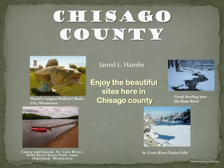
Chisago County. Jarrod L. Hamlin. Enjoy the beautiful sites here in Chisago county. Canoe and Kayak, St. Coix River, Wild River State Park, near Almelund , Minnesota. Creek feeding into the Rum River. World's Largest Walleye? Rush City, Minnesota. St. Croix River,Taylor Falls.

E N D
Chisago County Jarrod L. Hamlin Enjoy the beautiful sites here in Chisago county Canoe and Kayak, St. Coix River, Wild River State Park, near Almelund, Minnesota Creek feeding into the Rum River World's Largest Walleye? Rush City, Minnesota St. Croix River,Taylor Falls Sources cited on last page.
Location of Chisago county Sources cited on last page.
Temperature’s in Chisago county The mean temperature for the year in Chisago county is 42⁰F Sources cited on last page.
Temperature’s in Chisago county The mean temperature for July in Chisago county is 68⁰F The mean temperature for January in Chisago county is 9⁰F Sources cited on last page.
Rum River Monitoring Station A gauging station is used to measure and keep track of water levels just like this picture of the rum river. This stations and many other s let Us know if a flood is on its way. Sources cited on last page.
The earths crust Below the land in Chisago county there is liquid rock !! we are just floating on a big land islands!! Sources cited on last page.
Fault lines Fault lines are many in Minnesota but have no worries there has been no recorded earthquakes in Chisago county Sources cited on last page.
Bedrock Most of Chisago county is made up of sandstone Shale and some carbonate. Sources cited on last page.
What the county is made of carbonate sandstone Shale -minerals that are Carbonate compounds Of calcium or magnesium or both -variety of sedimentary Rock consisting largely Of mineral partials of Sand grade size -fissile, sedimentary rock Of mud or clay composition, Showing lamination. Sources cited on last page.
Meandering river St. Croix River, Wild River State Park Meandering is when a river Bends back and forth building Deposits and eroding the bank back and forth Sources cited on last page.
St Croix bordering Chisago county(MN) and Wisconsin Loser Wisconsin Chisago county (MN) Sources cited on last page.
Lakes in Chisago county There are many activities to do with lakes. Here is a list of lakes in Chisago county. There are more smaller lakes not listed. kroon lake, green lake, Chisago lake, south center lake, south lindstrom lake, little lake, north center lake, sunrise lake, fish lake, goose lake, horse shoe lake, and rush lake Tanning Water skiing Fishing Canoeing Sources cited on last page.
Rivers in Chisago county Two rivers in Chisago county are the St Croix river and the Sunrise river The St Croix borders the County of Chisago Enjoy fishing Go boating Sources cited on last page.
Take a trip to Wild River State Park From I-35, take State Highway 95 to County Road 12. Drive 3 miles on County Road 12 to park entrance. Sources cited on last page.
At wild river state park You can see the river shore made of rocks sand ect. The rock was carried by the river onto the shore Sources cited on last page.
This is a diagram showing how a river carries rock (load) Streams carry their load as dissolved, suspended, and bed load. Suspended load is kept in suspension by turbulence. Bed load Moves by sliding or rolling. Sources cited on last page.
Also at wild river state park You can see how the St Croix cut through the land and left its mark. Sources cited on last page.
How it “cuts” through The cut bank(erosion) is where the water Erodes down the soil and the point bar (deposition) is where there is less current and it deposits back that same soil Sources cited on last page.
Ox-bow lakes A Meandering river A formed ox-bow lake A ox-bow lake is formed when a meandering river develop narrow necks , which Are cut through shortening the river coarse and leaving behind an abandoned meander loop. This is called a cut off. Oxbow-lake in Chisago county Sources cited on last page.
The Ice Age Sources cited on last page.
Subglacial and englacial drainage/streams When Chisago county was under ice there was many areas that had Streams or drainage under the ice sheet this created eskers. Sources cited on last page.
Eskers in Chisago county This is a nice looking esker ( not in Chisago county) Sources cited on last page.
Glacial Erratic If your walking along Chisago county and you see a boulder that looks way Out of place, it probably is. Its called an erratic. Sources cited on last page.
Glacial erratic (cont.) A Glacial erratic happens when a Ice sheet is moving and picks up A boulder and carries it far from It origin and when the glacier melts It leaves this huge out of place Boulder. The diagram helps under Stand the process. It is showing The melting phase a, b, and c . If you go backwards c, b, and than a You get the pick up process. Sources cited on last page.
Basic Map Pro’s Con’s Just like the Name implies This map is Simple and easy To read You miss a lot Of details you Just get the basics Sources cited on last page.
Hybrid Map Pro’s Con’s You get the easy To read aspect And you get the Realistic details That might be Easier for you To relate with. You don’t get as much technical Detail. Sources cited on last page.
Topographic Map Pro’s Con’s You get the technical side of the map and can Get a good idea Of the terain With the height Indications. Complicated to Read and isn't very Visually appealing Sources cited on last page.
Geology map of Chisago county Sources cited on last page.
ART INSTRUCTOR JEFF KNAPP “Today you’ll be doing another booklet” Sources cited on last page.
Credit where Credit is due • Google maps • Wikipedia, http://en.wikipedia.org/wiki/Chisago_County,_Minnesota • http://images.google.com/imgres?imgurl=http://www.weichert.com/images/counties/MN-Chisago.gif&imgrefurl=http://www.weichert.com/MN/Chisago • http://24.56.144.170/wf2_chisagopublic/Default.aspx • http://climate.umn.edu/img/normals/temp_norm_adj/temp_norm_adj_01.htm • http://www.metrocouncil.org/environment/riverslakes/Streams/Reports/Rum.pdf • http://www.indiana.edu/~g103/G103/week6/wk6.html • http://geo-site.net/physical/Project.html • Introducing Physical Geography(fourth edition) authors- Alan Strahler & Arthur Strahler The End