Download
1 / 18
180 likes | 184 Views
This project aims to test new sensors and instrumentation and collect data to develop a prediction model for updraft conditions at the "Lone Tree" launch site. The May 2011 flight included a thunderstorm intercept mission, capturing valuable data. The flights utilized various payloads, including Holux GPS and MicroLite temperature dataloggers.

E N D
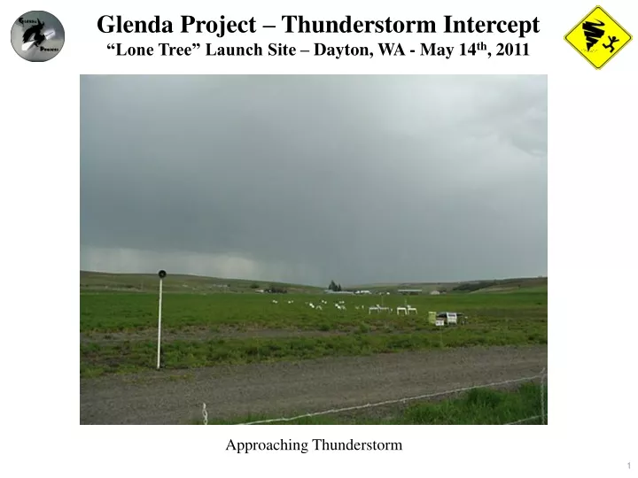
Glenda Project – Thunderstorm Intercept “Lone Tree” Launch Site – Dayton, WA - May 14th, 2011 Approaching Thunderstorm
“Lone Tree” Launch Site – May 14th, 2011 The purpose of our Glenda Flights at the “Lone Tree” launch site are essentially two fold. The first is to test out new sensors and instrumentation, and second to develop a data set in support of a prediction model so that members of BMR could predict the brutal updraft conditions that often exist at this site. This model would allow modelers to hold a safer launch as that larger birds would now stay within the boundaries of the launch site. The Glenda flight plan for the May 2011 launch consisted of two flights. The first, was to be the flight of our new Holux GPS 4D datalogger system, and the second, the first flight of our 54mm High Velocity booster. Well, nature threw us another curve. As we were preparing the Holux datalogger payload for flight, a line of thunderstorms moved through the area. The mission plan then changed to “Thunderstorm Intercept” to see what data could be captured. Based on the success of the September 2010 launch, we knew that the capsule could withstand the environment. The flight was major success and the data is presented in the following slides.
“Lone Tree” Launch Site – May 14th, 2011 Booster Flight Plan • 7554 - 75mm Booster / 54mm Capsule • 3” diameter booster, 2.125” diameter capsule • Holux M-241 and MicroLite datalogger payloads • Optimal capsule sink rate of 20 feet per second • Aerotech I211-M motor for a 3,000 foot altitude • 5475 - HV Booster • 2.125” diameter booster, 3” diameter capsule • RS92 Digital Radiosonde Payload with GPS • I218 CTI 54mm motor with 4,000 foot altitude
“Lone Tree” Launch Site – May 14th, 2011 The one flight that was made at the May BMR launch contained a dual datalogger payload. The first was a Holux M-241GPS 4D datalogger which would capture lattitude, longititude, elevation, plus motion (ie 4 Dimensions, or 4D) at one second intervals. The second payload was a MicroLite USB Temperature datalogger also sampling at one second intervals to gather temperature data above the launch site. Both payloads performed remarkably well and handled the flight loads without a problem. The GPS payload also gave us the opportunity to test out our cellular internet system. Terrain was against us for this one and we were never able to obtain a solid enough signal to support effective communications. Something to work on for the future.
Holux M-241 GPS Datalogger The M-241 is a high performance GPS datalogger. Capable memory size to record up to 130,000 positions, including longitude, latitude, time, and altitude. • Datalogger Specifications: • 32 parallel satellite searching channels • Receiver: L1m 1575.42 MHz • Adjustable sampling rates from 1 second + • Satellite signal reception sensitivity: -159dbm • Position: +/- 2.2 meters Horizontal • Powered by a standard AA battery with 12 hour life cycle • Size/Weight: 1.26 x 1.18 x 2.93" (32.1 x 30 x 74.5 mm)/approx. 2.5 oz.(71 grams) • Time to reposition: < 0.1 second average • Time to boot: 36 seconds (cold), 1 sec (hot) • Maximum Acceleration: 4G • Maximum Altitude: 60,000 feet (18,000 m)
Holux M-241 GPS Datalogger Software System software applies recorded data through the Google earth application to produce path maps, plus altitude and velocity charts. Data is downloadable in both *.html, and *.csv formats for external data manipulation.
MicroLite Temperature Datalogger The MicroLite USB Datalogger is a small electronic device for monitoring and recording temperature. Manufactured to stringent IP68 standards, the MicroLite logger is dustproof and is only 4.3” long and 1” thick. The data logger features a three digit LCD display, direct USB connection, wide temperature range, high accuracy and large sample memory. Data can be displayed on the small numeric screen or downloaded to the MicroLab Lite software via the USB 2.0 connector. • Datalogger Specifications: • Internal Temp Sensor: -40°C to 80°C Thermal Conductor • enabling a fast sensor response time • Sampling Resolution A/D Resolution: 16Bit 0.1°C • Data Storage Capacity: 16,000 Samples • Sampling Rate: 1 per second to 1 per 2 Hours • Battery: Replaceable 3V Lithium Battery - CR2032 • Battery Life: 2 Years at 1 second Sampling Rate • Dimensions: 11cm x 3.9cm x 2.6cm (4.3" x 1.5" x 1.0") • Weight: 45.5 grams (1.6oz) • Software: MicroLab Lite for Windows • Standard Compliance: IP68, NEMA6 (30 Minutes for 0.5 meter Depth) CE, FCC
Holux M-241 GPS Datalogger The following slide shows the data collected by the Holux and MicroLite dataloggers during the May flight. While the ground track and velocity data displayed by the supplied Holux software is interesting, it does not provide the visibility that the data is capable of displaying. Our Glenda 4D mapping software allows the data to be shown in its true fidelity displaying the motion of the capsule as it descends. However, the raw data captured by the dataloggers now allows us solid wind velocity And updraft / downdraft data to build a more effective prediction model. With the MicroLite Temperature datalogger and GPS datalogger running in parallel using matching sampling rates, a viable temperature data model could now be made.
“Lone Tree” Launch Site – May 14th, 2011 Holux M-241 GPS Datalogger - Groundtrack
“Lone Tree” Launch Site – May 14th, 2011 Holux M-241 GPS Datalogger – 4D Plot – Lattitude / Longitude / Altitude / Motion (Feet) (46 Degrees North) (117 Degrees West) Note: The numerous direction changes as the capsule descends
“Lone Tree” Launch Site – May 14th, 2011 Wind Speed versus Altitude Note: Wind Speed is increasing with Altitude
“Lone Tree” Launch Site – May 14th, 2011 Sink Rate versus Altitude Note: The “Baseline” Sink Rate of the capsule is 20 feet per second (-20) There are significant Updrafts and Downdrafts due to the approaching thunderstorm
“Lone Tree” Launch Site – May 14th, 2011 Temperature versus Altitude
“Lone Tree” Launch Site – May 14th, 2011 Groundstation Data Our groundstation continues to perform above expectations recording data at one second, and 1.5 second intervals. The falling barometric pressure indicated the approach of the coming thunderstorm. The increasing humidity reflected the coming rains. Ground wind speed remained relatively constant even though winds aloft were increasing rapidly. A few hours later the ground wind speed became excessive. The ability of the payloads to detect winds aloft serve as a pre-cursor for events later at ground level.
“Lone Tree” Launch Site – May 14th, 2011 Groundstation Wind Speed Launch Time 11:57 am
“Lone Tree” Launch Site – May 14th, 2011 Groundstation Temperature and Relative Humidity Launch Time 11:57 am
“Lone Tree” Launch Site – May 14th, 2011 Groundstation Barometric Pressure Launch Time 11:57 am
“Lone Tree” Launch Site – May 14th, 2011 In Conclusion At the May BMR launch, the Glenda Project achieved one of our primary goals of intercepting a severe weather system, collecting usable data, and returning safely. For the June BMR launch, we plan a second flight of the Holux datalogger and the flight of the 54mm HV Booster with it’s radiosonde payload. The purpose of the June flights will be to continue to collect data to support the “Lone Tree” updraft / downdraft prediction mode. Our flights would not be the success that they are without the continued support of the members and leadership of BMR. We couldn’t do it without you.