Download
1 / 15
150 likes | 310 Views
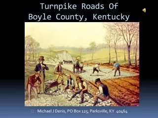
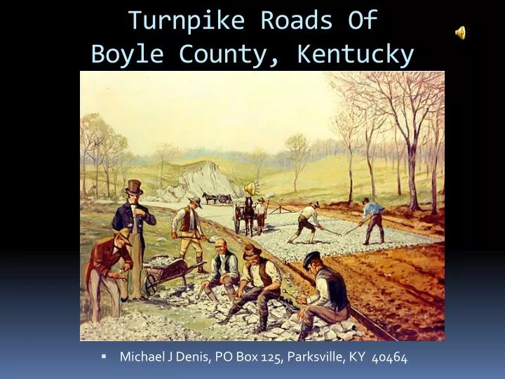
Turnpike Roads Of Boyle County, Kentucky. Michael J Denis, PO Box 125, Parksville, KY 40464. John McAdam & British Turnpikes. His process called “macadamisation” Road surface needed to be raised Built with layered, increasingly small rocks and gravel.

E N D
Turnpike Roads Of Boyle County, Kentucky • Michael J Denis, PO Box 125, Parksville, KY 40464
John McAdam & British Turnpikes • His process called “macadamisation” • Road surface needed to be raised • Built with layered, increasingly small rocks and gravel • Center higher than the sides for rain runoff • His roads were 30 feet wide • Built beginning 1816 • Method copied here, with the “National Road”
Early American Turnpikes • National Road, connecting Cumberland, MD and Vandalia, IL • Completed 1839 • Now parallels much of I-68, and US-40 • First “interstate” road built with Federal money • “Metal” refers to paving with stone. • “Metalled” roads were stone-covered roads. • Many early charters used the term, or a variant.
Turnpikes in Kentucky • First one, chartered in 1797, was to run from Crab Orchard to Cumberland Gap • First “modern” turnpike, 1818, from Louisville to Maysville through Lexington • Cost of shipping goods dropped • Travel time decreased, Louisville to Nashville down to 2 days
Turnpikes in Kentucky • By 1835, finished miles completed: • 13 miles in Anderson • 10 miles in Mercer • 28 miles from Springfield to Danville • 25 miles from Danville to Lexington • 12 miles from Lexington to Perryville • Seemed like a good investment for KY • BUT, most roads ranged from 0.09% to 4.02% return • By 1850, KY cut investments, but now burden fell to counties and cities.
Turnpike Rates and Rules • 1850, first road rules • Keep to right • Pass on left • Tolls often based on width of tire • Narrow tires, higher tolls because narrow tires did more damage to the road • Horse, mule, rider 5c • Head of cattle ,2c ea • Hogs, 1/2c • Pleasure vehicles, 25c • Union armies charged half toll, by 1862 US stopped payment – troops were “defending Kentucky”
Turnpike Rates and Rules • 1868, county courts allowed to invest • 1870, people going to and from church or attending funerals were exempted • Many other local exemptions – scholars going to school, etc. • By 1870s, roads were often not profitable • Danville & Perryville income was $2096, expenses $1856, didn’t leave much for road improvement • 1886 – New York Times commented on good quality of KY roads
Effects of the Turnpikes on KY • From Liberty to Stanford, to Elizabethtown, to Louisville, to Maysville and Newport, much of KY was covered with good roads. • Property values increased • Some county seats had from 5 to 12 macadamized roads • Some passed through gates at night when they were open • Some went through fields around gates or took parallel roads (shunpiking)
The “Turnpike Wars” • James Marrs, editor of Kentucky Advocate of Danville, as early as 1884, suggested the state take over the turnpikes • Began Sep 1896, in Washington County • People thought tolls were too high • NY Times, 7 Dec 1896 -mob chopping down 6 gates in Harrodsburg • 300 Gates destroyed since September 1896 • Shootings in Perryville, 22 Mar 1898, 75 raiders • By 1900, violence had worked. Not a good omen for Kentucky’s future
End of the Turnpike Era • By 1910, Boyle owned 120 miles of turnpikes • By 1908, only good roads were turnpikes • Local roads still forced men to work on the roads • Boston Evening Transcript, 7 Jan 1914, said people evaded tolls - “shunpiking”, taking parallel roads. • 1912, state began to take over highways • 1916 and 1921 allowed state to use gas taxes and license fees for road construction • Resurgence 1956 on – KY Turnpike (now I-65, Louisville-E’town), and 631 miles of toll parkways
Tunpikes in Boyle County • Many roads were chartered but not built • Many were absorbed by other companies • Much duplication of routes causes confusion • Much overlapping due to differing charters • Frankfort to Crab Orchard, 1834 • Danville, Lancaster & Nicholasville, 1834 • Springfield, Perryville & Danville 1836 • Danville & Hustonville, 1844 • Clarks Run & Salt River (Lebanon Pike), 1847
Turnpikes of Eastern Boyle County 2 – Danville, Lancaster & Nicholasville 6 – Danville & Hustonville 8 – Clarks Run & Salt River (Lebanon) 14 – Knob Lick 16 – Danville & Pleasant Hill 24 – Lincoln & Boyle 29 – Danville & Harrodsburg 30 – Danville & Stanford
Turnpikes of Western Boyle County 3 – Kentucky & Green River 4 – Nicholasville, Harrodsburg & Perryville 5 – Danville & Springfield 7 – Springfield, Perryville & Danville 8 – Clarks Run & Salt River (Lebanon) 9 – Danville & Perryville 10 – Perryville & Springfield 11 – Perryville & Taylorsville 12 – Springfield, Maxville & Perryville 13 – Perryville & Lebanon 15 – Perryville & Union Meeting 19 – Perryville & Maxville 20 – Perryville & Mitchellsburg 21 – Perryville & Steam Mill 23 – Parksville (Crosspike) 25 – Pine Knob (Alum Springs CP) 26 – Quirks Run & Nevada 28 – Chaplin & Quirks Run