Download
1 / 36
380 likes | 665 Views
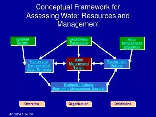
EMDS 3.2: (Ecosystem Management Decision Support system) a modeling framework for forest fuels evaluation and fuel treatment planning . Keith Reynolds, Paul Hessburg Pacific Northwest Research Station Bob Keane Rocky Mountain Research Station. Outline. Introduction to EMDS A short history

E N D
EMDS 3.2:(Ecosystem Management Decision Support system)a modeling framework for forest fuels evaluation and fuel treatment planning Keith Reynolds, Paul Hessburg Pacific Northwest Research StationBob Keane Rocky Mountain Research Station
Outline • Introduction to EMDS • A short history • Basic concepts and features • Applications in forest fuels • Prototype for USGS map zone 16 • FY07 USFS national and regional prototype • Current applications for FY08 • The future
Version history • Version 1, 1997 • USFS Research, Northwest Forest Plan • Version 2, 1998 • USFS Research, EPA OR&D, USFS EM (WO) • Version 3 • 2002, v3.02, Natural Resource Information System (WO) • 2004, v3.1, EMDS consortium (Redlands Institute) • 2007, v3.2, EMDS consortium (Redlands Institute)
EMDS development consortium • PNW Station • System design & project oversight • Redlands Institute • EMDS stewards and ArcGIS implementation • Rules of Thumb, Inc. • NetWeaver logic engine and OCX • InfoHarvest, Inc. • Priority Analyst engine and OCX
Design objectives • Improve the efficiency with which landscape evaluation is conducted • Optimize use of information • Improve the quality of evaluation products • More comprehensive analysis • Better integration of diverse topics • Integrated support for planning
Integrated evaluation and planning • Evaluation within scale • Concurrent evaluation of possibly numerous states and processes within a single analysis • Across scale • Explicit linkage of evaluations across spatial scales • Comparing evaluations over time • Across phases of adaptive management • Going from landscape evaluation to planning
Version 3.2 implementation • EMDS 3.2 is an ArcMap extension (ArcGIS 9.1+) • Microsoft Windows 2000, XP • Microsoft COM • Major components • Project environment (core) • Logic engine (logic-based evaluation) • Hotlink tool (intuitive graphic explanation) • Data Acquisition Manager (priority of missing data) • Priority Analyst (priority setting in planning)
Logic models • A form of meta database • A formal logical representation of how to evaluate information • Networks of interrelated topics • Mental map
Logic models: forms of uncertainty • Probabilistic uncertainty • Uncertainty of events • Linguistic uncertainty • Uncertainty about the definition of events • Vagueness or imprecision • A proposition is the smallest unit of thought to which one can assign a measure of truth (strength of evidence) • SE: a measure that quantifies the degree of support for a proposition provided by its premises
Degrees of support Bivalent reasoning Yes Partial Yes No No Logic models: strength of evidence An example: strength of evidence for suitable slope for tractor logging.
Map products • Basic EMDS output is maps. • Symbology displays strength of evidence for a conclusion. • Advantage of a logic-based solution. • Not a “black box.”
Hotlink browser: explaining results • Used to view the evaluated state of a logic model for a selected map feature. • The graphic display of the evaluated state of a knowledge base is relatively intuitive. • Provides a detailed explanation of the derivation of conclusions. • Valuable to EMDS developers, users, and the general public
Priority Analyst (PA) • PA is a Multi-Criteria Decision Analysis (MCDA) component • Assists in ranking landscape elements, based on how well each rates against a set of decision criteria. • Uses output from the landscape evaluation and a decision model. • Rates landscape elements with respect to • their condition, and • factors related to the feasibility and efficacy of management.
Priority analyst output Aspatial output Spatial output
Priority analyst diagnostics In this example, a 13.4% change in the weight on the WS condition criterion would lead to a change in ordering of priorities. How primary criteria in a decision model contribute to the total priority score for a watershed.
A single unified model for planning • Assess current condition • Context for planning (where are we starting from?) • Evaluate alternative strategies • A framework for synthesizing results of projections • Harvest scheduling, vegetation modeling, etc. • Priority Analyst for more tactical decisions • Which activities to do where? • Evaluate plan implementation • How well is the plan working?
Outputs versus outcomes • Change in performance standards of federal agencies • Old (outputs): acres treated per year • New (outcomes): acres of reduced fire danger per year • New planning rule and EMS • Adaptive management (ISO 14001) • Hypothesis testing • Shift in distribution of outcomes?
In this prototype, we characterized fire danger for all 575 complete watersheds in map zone 16. The average watershed size was ~ 8274 ha.
Level 1: Fire danger evaluation… fire behavior + + fire hazard ignition risk =
FY07 USFS prototype: fuels evaluation and priorities for Regions and Forests All data obtained as, or converted to, 1-km grids.
Data sources for decision model All data obtained as, or converted to, 1-km grids.
Wildfire danger across Forests Relative wildfire danger for Forests in western US. Map is symbolized as relative potential, based on 5 equal-interval classes, to better depict variation among Forests.
Regional priorities Regions with the highest wildfire potential are not necessarily the highest priority. Priorities are strongly influenced by the other logistical considerations in the decision model.
Outcomes of the FY07 USFS prototype • At least a few bumps and warts • Logic had to be highly simplified for existing data • Questionable data layers • But the FY07 test met a basic need • Rational and transparent models • Refining the process in FY08 • New prototype for USFS • Extending to all DOI resource agencies
The future … • FY08 - expansion to Department of Interior • BLM, BIA, Park Service, Fish & Wildlife Service • Integrated priorities across agencies and across Regions within agencies • FY09 - ramping up to western US • Logistics are a major issue • Continued refinement of logic and decision models • Possible integration across all natural resource agencies???
Contact information • Phone: +01-541-750-7434 • Email: kreynolds@fs.fed.us • Website: http://www.institute.redlands.edu/emds/