Download
1 / 7
70 likes | 164 Views
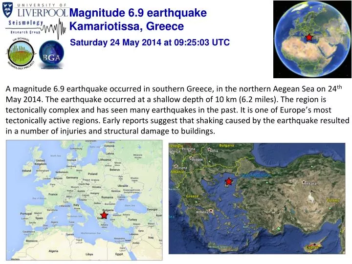
Magnitude 6.9 earthquake Kamariotissa, Greece. Saturday 24 May 2014 at 09:25:03 UTC.

E N D
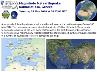
Magnitude 6.9 earthquake Kamariotissa, Greece Saturday 24 May 2014 at 09:25:03 UTC • A magnitude 6.9 earthquake occurred in southern Greece, in the northern Aegean Sea on 24th May 2014. The earthquake occurred at a shallow depth of 10 km (6.2 miles). The region is tectonically complex and has seen many earthquakes in the past. It is one of Europe’s most tectonically active regions. Early reports suggest that shaking caused by the earthquake resulted in a number of injuries and structural damage to buildings.
Magnitude 6.9 earthquake Kamariotissa, Greece Saturday 24 May 2014 at 09:25:03 UTC Where was the earthquake felt? Most significant shaking was felt within a 300 km radius of the earthquakes’ epicentre. The strongest recorded felt intensity VI (strong shaking).The earthquake was felt nearby countries including Turkey (including Istanbul), Greece, Bulgaria, Romania, (including Bucharest), Serbia, Albania. Distribution of shaking reports (image from EMSC) Modified Mercalli Intensity Scale
Magnitude 6.9 earthquake Kamariotissa, Greece Saturday 24 May 2014 at 09:25:03 UTC Past earthquakes in the region Moderate-sized, shallow earthquakes in this part of the Aegean Sea are not unusual. The 24th May 2014 earthquake, however, is the largest to have occurred in this region since records began in 1970. Prior to May 2014, the largest recorded events were two M6.7 earthquakes in 1975 and 1983. Historic seismicity (since 1970) showing magnitudes of greater than 5 in the region. The earthquake epicentre is indicated by the red circle. Earthquake locations from the USGS catalogue.
Magnitude 6.9 earthquake Kamariotissa, Greece Saturday 24 May 2014 at 09:25:03 UTC What caused this earthquake to occur? The Eastern Mediterranean region is seismically active due to the northward convergence (4-10 mm/yr) of the African plate with respect to the Eurasian plate along a complex plate boundary. The Northern Anatolian Fault (NAF) is a major fault line caused by the collision of the Arabian plate and the westward escape of Anatolia (Turkey). The NAF separates the Anatolian/Aegean plates and the Eurasian plate and results from the westward escape of Turkey resulting from the collision of the Arabian continent. The 24/05/14 earthquake likely occurred along a westernmost strand of the Northern Anatolian Fault. This is consistent with right-lateral strike-slip faulting along the west-east trending fault plane as shown by the earthquake’s focal mechanism. USGS focal mechanism of the earthquake. Arrows show the most likely sense of faulting along the west-east trending fault plane. Tectonic setting of the Eastern Mediterranean region Schematic illustration of right-lateral strike-slip faulting
Magnitude 6.9 earthquake Kamariotissa, Greece Saturday 24 May 2014 at 09:25:03 UTC Aftershocks So far, over 70 aftershocks have been recorded by the EMSC. Most of these have been small (M < 4), but the largest aftershock was a magnitude 5.0 earthquake that occurred just six minutes after the mainshock. Most aftershocks have so far occurred to the east of the mainshock epicentre. More moderate aftershocks can be expected. Map of aftershocks recorded (red circles). The mainshock location is indicated by the red star.
Magnitude 6.9 earthquake Kamariotissa, Greece Saturday 24 May 2014 at 09:25:03 UTC Recordings of the earthquake from the British Geological Survey seismometer network
Magnitude 6.9 earthquake Kamariotissa, Greece Saturday 24 May 2014 at 09:25:03 UTC Find out more … • USGS webpage for this earthquakes http://earthquake.usgs.gov/earthquakes/eventpage/usb000r2hc#summary • EMSC webpage for this earthquake: http://www.emsc-csem.org/Earthquake/earthquake.php?id=379935 • BGS (British Geological Survey) – seismology and earthquakes – frequently asked questions http://www.earthquakes.bgs.ac.uk/education/faqs/faq_index.html • IRIS (Incorporated Research Institutions for Seismology) – learning about earthquakes http://www.iris.edu/hq/programs/education_and_outreach/students • UK School Seismology Project – classroom activities, videos and support documents http://www.bgs.ac.uk/schoolseismology/home.html • USGS (United States Geological Survey) – FAQs, glossary, posters, animations http://earthquake.usgs.gov/learn/ • EMSC (European Mediterranean Seismological Centre) http://www.emsc-csem.org/