Download
1 / 29
290 likes | 414 Views
THE ROLE OF GROUND WATER IN THE METHLYLATION OF MERCURY, WEEKS BAY WATERSHED, ALABAMA UNITED STATES GEOLOGICAL SURVEY IN COOPERATION WITH THE WEEKS BAY NATIONAL ESTUARINE RESEARCH RESERVE. WEEKS BAY WATERSHED, ALABAMA.

E N D
THE ROLE OF GROUND WATER IN THE METHLYLATION OF MERCURY, WEEKS BAY WATERSHED, ALABAMA UNITED STATES GEOLOGICAL SURVEY IN COOPERATION WITH THE WEEKS BAY NATIONAL ESTUARINE RESEARCH RESERVE
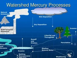
Methylmercury (CH3HG+) is the most toxic and bioaccumulative form of Mercury.
The methylation process is widely thought to be driven by naturally occurring sulfate reducing bacteria in anaerobic sediments.
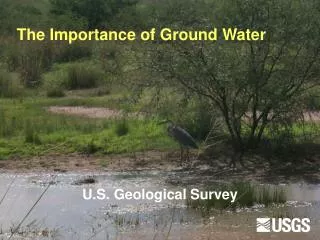
Why Ground Water? Most of the water in streams and rivers is ground water; Key water-quality conditions necessary for the methylation of Mercury are associated with ground-water quality.
Study Objectives Provide data to help manage the resource; Determine the influence of ground-water discharge on surface-water ecology; Test concepts and methods.
Study Tasks Identify areas of ground-water discharge; Determine the quality of ground water discharged to the surface-water system; Relate ground-water discharge to the methylation of mercury.
Ground Water Sample Sites Well Nest Line of Hydrogeologic Section WEEKS BAY
Ground-Water Quality 8-11-04 WW-15 WW-16 Depth of Screens (feet) 74 - 79 3 - 8 pH (s.u.) 4.8 5.8 DO (mg/L) 8.5 1 Conductance (mS/cm@25oC) 51 5000 Methyl Mercury (ng/L) < 0.04 0.58 Sulfate (mg/L) 0 80 Sulfide (mg/L) 0.02 0.25 Temperature (oC) 20.5 26.5
Thermal Photography Thermal mapping provided by VeriMap Plus Inc. and Eagleview Industries Inc.
Temperature and Specific Conductance Main Channel, Fish River, 8/11/04 Water Temperature uS/cm oC Specific Conductance Upper Basin Lower Basin
Distribution of Methylmercury and Temperature Main Channel, Fish River, 8/11/04 Methylmercury (ng/L) ng/L oC Water Temperature (oC) Upper Basin Lower Basin
3 Fish, 0.52 mg/L/yr 7 Fish, 0.54 mg/L/yr 8 Fish, 0.43 mg/L/yr 14 Fish, 0.24 mg/L/yr Mean Bioaccumulation Rates Main Channel, Fish River Fish data provided by the Weeks Bay NEP
Mercury in Fish (mg/L/yr) oC mg/L/yr Temperature (oC) Upper Basin Lower Basin Fish data provided by the Weeks Bay NEP Mean Bioaccumulation Rates (mg/L/yr) and Temperature, Main Channel, Fish River
Mean Bioaccumulation Rates (mg/L/yr) 3-Year Old Fish, Main Channel, Fish River Upper Basin Lower Basin Fish data provided by the Weeks Bay NEP
Mean Bioaccumulation Rates (mg/L/lb) for Fish of Similar Weight, Main Channel, Fish River Upper Basin Lower Basin Fish data provided by the Weeks Bay NEP
SUMMARY Shallow Ground water collected from organic rich sediments in the Weeks Bay Watershed contained methylmercury.
SUMMARY Ground-water level measurements made in WW-15 and WW-16 indicate that ground-water levels increased with depth in the vicinity of Weeks Bay.
SUMMARY Thermal mapping showed that cooler, ground-water discharge, became dominate in an upstream direction.
SUMMARY Mercury in Fish (mg/L/yr) oC mg/L/yr Temperature (oC) Upper Basin Lower Basin Mercury content of largemouth bass and surface-water samples showed the same pattern of geographic distribution as water temperature.
SUMMARY CAUTION: The fish tissue sample size is limited, and not evenly distributed throughout the basin; Ground-water has been sampled and analyzed for mercury only in the vicinity of Weeks Bay; Better geographic coverage and additional data collection are needed.
Precipitation and Particulate Sampling April – September, 2005
Paired Basin Investigation Polecat Creek Waterhole Branch
Bioaccumulation Rates (mg/L/yr) Min Med Max Waterhole Branch 0.1 0.16 0.18 Polecat Creek 0.1 0.36 0.48 Fish data provided by the Weeks Bay NEP