Download
1 / 15
150 likes | 203 Views
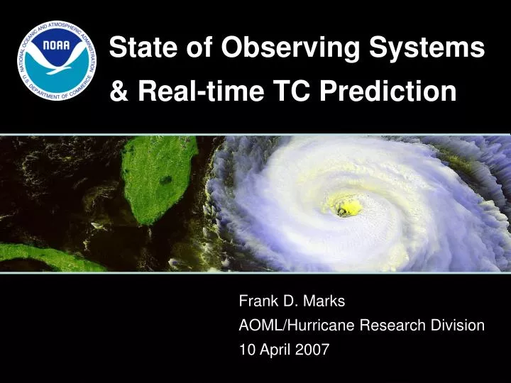
State of Observing Systems & Real-time TC Prediction. Frank D. Marks AOML/Hurricane Research Division 10 April 2007. Intensity. Track. Mean Absolute Error of the 1985-2006 NHC Atlantic Intensity and Track Forecasts. Where are we at?.

E N D
State of Observing Systems & Real-time TC Prediction Frank D. Marks AOML/Hurricane Research Division 10 April 2007
Intensity Track Mean Absolute Error of the 1985-2006 NHC Atlantic Intensity and Track Forecasts Where are we at? 48-hr track forecasts have improved 3.5% per year on average since 1985, while intensity forecasts have improved about 0.8% per year
How is Intensity defined? • Maximum sustained surface wind: • Maximum wind, averaged over a 1 minute interval at an altitude of 33 ft (10 m), associated with the circulation of the tropical cyclone at a given point in time. • With very, very few exceptions, direct observations of the maximum sustained surface wind in a tropical cyclone are not available.
Intensity/Structure • Sensitive to environmental circulation outside core • Sensitive to ocean, interactions, and changes along track • Sensitive to inner core dynamics • Sampling of these limited by presence of heavy rain, clouds, strong winds. Rely on what we can get (i.e., radar, aircraft, satellite: microwave, IR, and visible) • Issues include: • poor data coverage in important areas, particularly in region surrounding core. • temporal and spatial resolution (3-6 h, horizontal 5-10 km, and 1 km vertical)
How Do We Estimate Intensity/Structure? • Satellites • Geostationary IR and VIS (Dvorak technique) • AMSU • QuikSCAT • Surface observations • ships, buoys, land stations (limited) • Aircraft reconnaissance • flight-level winds • GPS dropsondes • Stepped Frequency Microwave Radiometer (SFMR) • Airborne Doppler radar
Geostationary Satellites • Geostationary satellites are used to locate the center and estimate intensity (VIS and IR) Sept. 15, 2004
Ocean Surface Vector Winds QuikScat detail – Katrina (2005) Windsat detail – Isabel (2003)
Intensity/Structure Vq Vr, w Airborne Doppler-analyzed wind field Hurricane Katrina, 28 September 2005
Observation Requirements • Collect observations that are targeted • throughout TC life cycle for development of data assimilation of core circulation • in and around storm circulation for evaluation of NWP models • in variety of atmospheric/oceanic conditions to assess influence of these conditions on observed and model TC intensity and structure changes • Improve our physical understanding of and develop improved model representations of • sea spray/surface flux effects on ABL structure and microphysics • intensity and structure change during decay. • Genesis • rainbands & eyewall replacement cycle
Observations over mature storm life-cycle Hurricane Ivan 09/08 06Z 09/08 12Z 09/09 12Z 09/10 06Z 09/10 18Z 09/11 06Z 09/11 12Z 09/12 06Z 09/12 12Z 09/13 06Z 09/14/06Z
Concentric Eyewall Cycle What did it do to intensity estimates? Hurricane Ivan
Where are we at? • NOAA/SAB HIRWG Report, Dec 2006 • 35 recommendations in areas: • Advanced NWP Systems • Develop and Test Novel Methods for DA • Improved Observations of the Hurricane and its Environment • Organizational changes to achieve a critical mass • Acceleration of Research to Operations • NSB report on broader hurricane issues, Feb 2007 • Proposes multi-agency National Hurricane Research Initiative (NHRI) to implement general recommendations • NHRI carries an additional investment of ~$300M/yr in hurricane science and research
Where are we at? • OFCM JAG/TCR Report: • 5-10 year plan for Federal TC research - Feb 2007 • Made 5 major recommendations dealing with research & its coordination, NWP, observing program, warning program review, education & outreach • Recommends resource increase of $85M/yr http://www.ofcm.gov/tcr/tcrplan.htm “…US must engage in a nationally coordinated, multi-agency and multi-dsiciplinary research initiative to greatly expand our understanding of hurricanes….”
Where are we at? A Major Undertaking (No Quick Fix) requiring all Federal Agencies (DOD, NASA, NOAA, NSF), and Universities (UCAR) to work together to: • Improve understanding of physical processes that lead to intensity and structure change in hurricanes through better use of models and observations • Develop and test tools and technologies needed for an integrated TC forecasting system that is based on state-of-the-art NWP models, DA, and observations • That is why we are here!