Download
1 / 12
120 likes | 241 Views
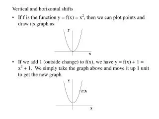
Horizontal Datum Shifts in NHD. History and Action Plans in Place. NHD Create Process. 2002 USGS, USFS, and others begin work to produce 24k (High Resolution) NHD Different file types used to create initial point, line and polygon vector datasets Digital Line Graph (DLG)

E N D
Horizontal Datum Shifts in NHD History and Action Plans in Place
NHD Create Process • 2002 • USGS, USFS, and others begin work to produce 24k (High Resolution) NHD • Different file types used to create initial point, line and polygon vector datasets • Digital Line Graph (DLG) • Cartographic Feature File (CFF) • Tagged Vector Hydro (TVH) • Technicians assigned to do a group of quadrangles within a subbasin • Most quadrangles were in North American Datum 1927 (NAD27) and had to be converted to NAD 1983 by transformation • 2007 • Conversions and conflation of Nationwide 24K (High Resolution) geodatabase completed
What was used in the NHD Create Process? (AK 98% TVH or other data; HI, PR, Guam mostly DLG)
Discovery of Horizontal Datum Shifts • November 2008 - Dean Tyler and a colleague from USGS Earth Resources Observation and Science (EROS) developed method to compare NHD streamline end-points with DLG end-points • Examined 1271 7.5’ quadrangles • 36 quads were determined to have a horizontal datum shift (>28M shift) • 4 quads were in the “possible” category • Two contiguous groups of quadrangles - 15 in VA, 18 in NM • Total USGS 7.5 Minute Quadrangles – 65,532 • 20,806 quads converted from only DLG, most other quads were converted from CFF (6668), CFF+DLG (3697), or TVH (34361) • Dean estimated that approximately 3% of quadrangles where DLG were used could be affected based on these findings – approximately 735 quadrangles
How did this happen? • Seems to be limited to areas of grouped quadrangles • Incorrect projection assigned upon conversion of source data • Projection deleted or no transformation applied • Source data incorrectly assigned projection
Correcting Horizontal Datum Shifts • Phase I – Detection and verification, establish areas of interest (AOI) • Phase II – Extraction (clipping), conversion (pgdb2shp), transformation applied, visual check with source data • Phase III – Erase, load feature changes (ArcCatalog Load), update status table (Load of ComID and Modify Geometry status) • Phase IV – Edge matching and merge features • Phase V – Verification of correction, Run QA/QC process, upload to repository