Download
1 / 25
250 likes | 325 Views
CHAPTER 3. Transportation, settlement, & growth. TRANSPORTATION. Has always been linked to: Settlement Growth Determines where people live and businesses develop The main source of transportation in early MS was rivers . TRANSPORTATION . 3 most important rivers for travel and trade

E N D
CHAPTER 3 Transportation, settlement, & growth
TRANSPORTATION • Has always been linked to: • Settlement • Growth • Determines where people live and businesses develop • The main source of transportation in early MS was rivers
TRANSPORTATION • 3 most important rivers for travel and trade • Mississippi • Yazoo • Big Black
ROADS • Early roads were Indians Trails and Buffalo Paths • Rivers were better than roads for the following reasons • Roads were more difficult and dangerous than boat • Couldn’t carry as much as boat • Roads were more expensive • The first roads were called post roads
ROADS • The Natchez Trace was the most famous road ever created in MS • Connects Natchez to Nashville • Stands (hotels or inns) were built along the Natchez Trace
ROADS • Roads then were not like today • Mainly dirt trail • Widened by cutting trees • Muddy • Couldn’t carry much • No bridges • Used ‘fords’ to cross rivers • Ford - shallow spot of water that can be crossed • Not as efficient as water, but went were water wasn’t located
STEAMBOATS • Created by Robert Fulton • Made upstream transportation possible • Carry as much as several flatboats • It allowed for the interior of MS to be opened for cotton plantations
RAILROADS • By 1900, Steamboats had mostly been replaced as way to travel & move goods • Civil War increased the need for Railroads • Reasons: ship soldiers and supplies • Advantages to the Railroad • Could be built anywhere • Faster & safer than steamboats • Opened settlement and economic development to areas without rivers • Economic development = more farmland
HIGHWAYS • 1920’s cars, trucks, & buses began appearing in MS • Roads were a problem • Dirt & gravel not good enough • Washed out and couldn’t handle loads • Bridges were unsafe or didn’t exist • No bridges crossed MS River (now 4) • Demands for government to build roads increased
HIGHWAYS • 1930’s – modern highway system began with federal money • Link major MS towns together and big towns in neighboring states • 1940’s bridges built over MS River at Vicksburg, Natchez, & Greenville
HIGHWAYS • 1960’s – 1970’s Federal Interstate Highway System constructed • At least 4 lane divided highway with same system across the country • Even #s go East and West • Odd #s go North and South • 3 digits are bypasses • About 42,800 miles and growing
INTERSTATES • MS’s Interstate’s • 55 runs the length of the state from Memphis to McComb • 20 runs across the state from Atlanta to Texas (crossing Meridian and Vicksburg • 10 runs across the coastal states • 59 runs from Hattiesburg to New Orleans
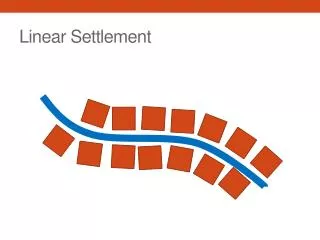
MS Counties, Towns, & Cities • Till 1940, MS almost all rural • Made living by farming • Lived off land, shopped at country stores, country doctors • Identified with their county • Paid taxes to county, law enforcement – sheriff • County school districts • Only in last 60 years have people moved to towns and cities
COUNTIES • 1st counties – Adams & Jefferson – 1799 • 13 counties in 1817 • Wayne County was 1st county east of Pearl River • Large land areas – small population
COUNTIES • Indian Treaties signed over land • 1820 – Treaty of Doak’s Stand • Choctaws ceded area of west central MS • Organized into Hinds County • Later split into 14 counties • 1830 Treaty of Dancing Rabbit Creek • Choctaws ceded the rest of their land in MS • 1832 Treaty of Pontotoc Creek • Chickasaw Indians cede their land in NE MS • Became 13 counties in MS
COUNTIES • New land – government wanted it settled so sold land cheap to draw in new settlers • RR and lumber boom in 1880 brought in more people to Piney Woods • Big counties started splitting up because people lived to far from county seats
TOWNS • Still today more people in MS live in rural area • MS is 4th most rural state in USA • Civil War only 4 towns of size: • Natchez, Vicksburg, Columbus, & Jackson • River cities – steamboats • After Civil War – Vicksburg would be MS largest city for 40 years • Steamboat and railroad center
TOWNS • 1910 railroad made Jackson & Meridian large towns • 1930 Jackson becomes and stays largest town in state • Metropolitan areas • Area with population of more than 100,000 • Several towns and cities grown into each other
TOWNS • MS Metropolitan Areas • Jackson Metro Area • Inside Hinds, Madison, & Rankin Counties • Gulf Coast • Desoto County – South Memphis • Hattiesburg
2010 CENSUS • About 2,967,000 people in MS • Most people in state still live in rural area even if they work in cities • Houston • 3,500 • Chickasaw County • 18,000
2010 CENSUS • Largest Cities • Jackson – 173,000 • Gulfport – 68,000 • Southaven – 49,000 • Hattiesburg – 46,000 • Biloxi – 44,000 • Largest Counties • Hinds – 245,000 • Harrison – 187,000 • Desoto – 161,000 • Rankin – 142,000 • Jackson – 140,000