Download
1 / 7
70 likes | 171 Views
Unmanned Arial Systems(UAS) for Lower Atmospheric Measurements. Naeem Tull-Walker 1, Dr. Demoz 2, Dr. Sakai 2 Grambling State University 1 , BCCSO 2. Overview of UAS Project.

E N D
Unmanned Arial Systems(UAS) for Lower Atmospheric Measurements Naeem Tull-Walker1, Dr. Demoz2, Dr. Sakai2 Grambling State University1, BCCSO2
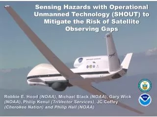
Overview of UAS Project • NCAS Beltsville Center for Climate System Observations (BCCSO) consists of a multidisciplinary group of Howard faculty in partnership with NOAA scientists (NWS and OAR), NASA/GSFC Earth Sciences Division, other academic institutions and government. • NCAS engages students in hands-on and experiential learning, research, and mentorship in areas related to NOAA science. At BCCSO, NCAS is leading a transformation in atmospheric research and education by inspiring traditionally underrepresented groups. • NCAS trains science and academic leaders to understand atmospheric processes through the application of state-of-the-art atmospheric observing systems and analytical methods. • Augmentation of the NCAS observations at the BCCSO by equipping model unmanned aerial systems (UAS) with humidity sensors, small aerosol samplers, and other devices to corroborate vertical profiling activities is the new phase in emerging technology development for NOAA. • A variety of platforms are being tested and evaluated for support of ongoing collaborative atmospheric observations in support of calibration/validation of NOAA satellite sensors and for the development of new observational technologies. These platforms include tethered balloons, various drones (quad-copters and octo-copters), and kites.
Research Objectives • 1. Payload design (integration, communication, weight). • 2. Experiment design (copter+balloon). • 3. Data analysis.. • 4. Physical Mx (radiation, T, RH, P, GPS winds) . • 5. In the future, extend to chemistry Mx (CO, O3, NOx, VOC, PM).
Sonde schematics • Analog: • Chem: O3, NO, NO2, PID • T, RH • Radiation Ground Station A/D convertor wires RF I2C RPi Accelerometer, Angles Direction Air pressure GPS USB RS-232 Sonic/wind
Q-copter payload: Sonde Prototype:
Tasks • Instrumentation: • Sonic set up • T/RH Calibration • INS • RF communication • Programming/Field • Raspberry Pi set up • Correlation of Thref data • Balloon calibration design • UAS-instrument mount • “FUN” • UAS simulator/control • Test flight Science study design Q.Whatproblem do you want to research? Focus on the Data Analaysis Aspects, learning the ins and outs of the Q-Copter , via test flights, categorization and calibrations of different instruments being used. Accurate data collection.
Please visit 1) https://www.arm.gov/sites/aaf/workshop2008/1016/0845to0900Reuder.pdf 2) http://www.weatherwise.org/Archives/BackIssues/2012/March-April2012/UAVs-full.html http://www.academia.edu/2199388/A_small_unmanned_aerial_system_UAS_for_coastal_atmospheric_research_preliminary_results_from_New_Zealand ftp://ftp.rap.ucar.edu/pub/rgf/kite_profiling.pdf http://uas.noaa.gov/ http://uas.noaa.gov/director.html