Download
1 / 30
300 likes | 440 Views
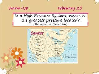
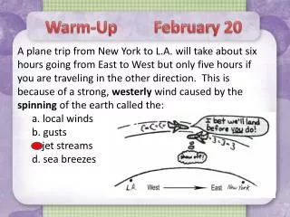
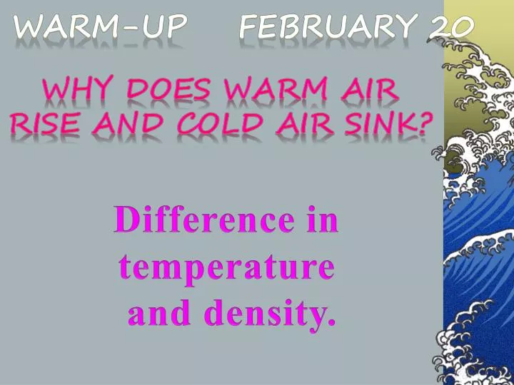
Warm-Up February 20. Why does warm air Rise and cold air sink?. Difference in temperature and density. Earth Science Rocks!. MYP Unit Question : What should I wear today? Area of Interaction : Environment Learner Profile : Communicator

E N D
Warm-Up February 20 Why does warm air Rise and cold air sink? Difference in temperature and density.
Earth Science Rocks! MYP Unit Question: What should I wear today? Area of Interaction: Environment Learner Profile: Communicator Standard: Understand how the distribution of land and oceans affect climate and weather
Learning Target: Today I am learning how to read a weather map because it will tell me what to wear each day. Opening: “What should I wear today in ______________? Work Session: Weather Symbols on a Weather Map Predict the Weather Closing: Exit Ticket – Map Symbols
What should I wear today in Unalakleet, Alaska? Temp: 9⁰ Fair & Breezy Wind Chill: -12⁰ (feels like) Humidity: 51% Wind Speed: 25 mph E Visibility:10 mi Dew point: -6⁰ http://climate.gi.alaska.edu/wx/current.html
Iditarod - Unalakleet Population: 819 796 miles into the race 19th checkpoint
Longest sled race in the world!
Meteorologists use weather maps and symbols to describe the weather.
Just like how you use :) in a text message to indicate a smile.
Where do Meteorologists get their information? • 870 land-based air stations • 150+ countries • An instrument (called a radiosonde) • attached to the balloon measures • the atmospheric pressure, air • temperature and relative • humidity. • Wind speed and direction are • calculated by tracking the • instrument with a high-gain • antenna (similar to a satellite-TV dish). • Balloon rises an average of 1000 • feet per minute. • Bursts around 100,000 ftabove ground
Two types of Satellites • Geostationary satellites • -constantly monitor the • Western Hemisphere • -22,240 miles above the • Earth • Polar-orbiting satellites - circles the Earth • around the poles • - 540 mi. above the Earth
Placed in space by a rocket.
Let’s get started learning this stuff.
Iso = same Isobars are lines that connect points of equal air pressure. (hint: measured with a barometer) Isotherms are lines that connect points of equal __________. (hint: measured with a thermometer)
Identify the fronts Occluded Stationary Cold Warm Cold Warm Occluded Stationary
Identify the fronts
Wind Direction Winds are named for the direction that they come FROM
North Westerly Wind
Southern Wind
Wind Symbols: Speed Calm Less than 5kts 5 kts 10 kts 50 kts
Now You Try It 45kts 15kts 20kts 25kts 30kts 40kts 35kts
Exit Ticket • Meteorologists collect and analyze much data to understand the complex conditions of the atmosphere in order to predict weather. Tell me how you have been a “thinker” while analyzing today’s data.
An area of low pressure is called a cyclone. Its winds spiral toward its center. The winds spin counterclockwise. Cyclone
Areas that have high air pressure are called anticyclones Cooler, denser air sinks and moves out of the center towards areas of lower air pressure. The winds rotate clockwise Anticyclone
Pic Collage—create an Earth Science Scrapbook MUST HAVES: Isotherms Weather Map symbols Warm Front Cold Front YOUR CHOICE: Global Winds Land /Sea Breeze Weather Instruments (barometer, anemometer, wind vane, etc.) Weather conditions (foggy, windy, etc.)