Download
1 / 42
440 likes | 718 Views
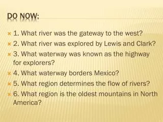
DO NOW. The map below shows some features along an ocean shoreline. In which general direction is the sand being moved along this shoreline by ocean (long shore) currents?. Glaciers. Ms. Ippolito and Mr. Hatten Earth Science. Glaciers. Large, slow-moving mass of ice

E N D
DO NOW • The map below shows some features along an ocean shoreline.In which general direction is the sand being moved along this shoreline by ocean (long shore) currents?
Glaciers Ms. Ippolito and Mr. Hatten Earth Science
Glaciers • Large, slow-moving mass of ice • Form from compacted layers of snow
Where Do We Find Glaciers? 1.High latitudes: • North Pole (Arctic) • South Pole (Antarctica) • 2.High elevations (altitude): • High in mountains The Baltoro Glacier in the Karakora Mountains, Pakistan. At 62 kilometres (39 mi) in length, it is one of the longest alpine glaciers on earth.
Types of Glaciers 1. Alpine glaciers, which are found in mountain terrains 2. Continental glaciers-ice sheets, which can cover larger areas Aletsch Glacier, Switzerland, the largest glacier in the European Alps
1. Alpine Glaciers • Confined to mountain valleys • Flow from higher to lower elevations A valley (or alpine) glacier in Alaska
To the right side of the photo is the ice-free valley of Talkeetna Glacier, Talkeetna Mountains, Alaska. Note cirque at the top of the valley on the left.
2. Continental Glaciers • Flow outward in all directions. • Antarctica and Greenland • Contain vast quantities of fresh water. Part of the Greenland Ice Sheet; Covers about 1.8 million Km2
How Do Glaciers Move? • Glaciers move downslope under their own weight due to gravity • Fastest Flow Velocity: • At the center • Near the ice surface 2009 2012
Erosional Features: 'U' shaped valley 1. U-shaped valley: Alpine (valley) glaciers carve U- shaped valleys through abrasion and plucking.
'U' shaped valley Glaciers reshape former V-shaped river valleys into U-shaped valleys!
Striations abrasion 2. Striations: scratches on existing surface by rocks that are embedded in the bottom of the glacier as it moves forward.
Glacial Ice Creates Sediment… When deposited by direct ice contact: • Unsorted • Various sizes • Angular Glacial Till
Landscape Features of a Receding Continental Glacier 1. Terminal moraine: till deposit that forms at the end of the glacier and marks the maximum advance of the glacier
Geologic Features of Long Island • Harbor Hill Moraine • Terryville Outwash Plain • Ronkonkoma Moraine • Hempstead Outwash Plain • Barrier Beaches The major geological features on Long Island’s surface are the result of glacial activity and coastal processes.
Ashley Schiff Preserve- Stony Brook University Harbor Hill Moraine
Landscape Features Continued… • Kettles- round depressions in the ground from blocks of ice becoming buried by glacial outwash • If water fills the holes, kettle lakes are formed Lake Ronkonkoma
Finger Lakes • Retreating glaciers deposited recessional moraines that blocked the water flow and created deep lakes • Seneca lake: 40 miles long, 618 feet deep • Cayuga: 40 miles long, 435 feet deep
http://upload.wikimedia.org/wikipedia/commons/5/5f/Fingerlakesmap.pnghttp://upload.wikimedia.org/wikipedia/commons/5/5f/Fingerlakesmap.png
Drumlin-long, smooth, canoe-shaped hill made of till • Narrow end points in the initial direction of ice movement • http://www.fettes.com/lothian/images/drumlin.jpg
Glacial Outwash • Formed of sediments deposited by melt-water streams at the end of glaciers • Sediment is sorted and layered (stratified) • Sediment may be rounded The western edge of Skeiðarársandur in Iceland shows the diffuse drainage channels typical of sandur.
Glacial Erratics • Glacial erratic- large boulder with differing composition than the local bedrock it now rests upon
Central Park NYC
Loess with Bank Swallow Burrows in a Coastal Bluff Loess – silt deposited by strong winds from the ice sheet.
Glacial Maximums • The Laurentide Ice Sheetwas a massive sheet of ice that covered hundreds of thousands of square miles • The Last Glacial Maximum that created Long Island’s surface topography occurred between 22,000 and 10,000 years ago • Some sections of ice were up to 2 miles thick, depressing the crust up to 300 meters
Glacial Rebound • The weight of ice causes the Earth’s crust to sink into the mantle • As ice melts, weight is removed and land’s elevation rises • Think of a seat cushion! http://www.geology.um.maine.edu/geodynamics/AnalogWebsite/602-2008/Wadoski_Web_Page/Glacial1.jpg
1. The moraines pictured in the block diagram were deposited directly by the glacier. The sediments within these moraines are most likely (1) sorted by size and layered(2) sorted by size and unlayered(3) unsorted by size and layered(4) unsorted by size and unlayered
During which geologic epoch did this glacier retreat from New York State? (ESRT p.8/9) Pleistocene Eocene (3) Late Pennsylvanian (4) Early Mississippian The shape of elongated hills labeled drumlins is most useful in determining the (1) age of the glacier(2) direction of glacial movement(3) thickness of the glacial ice(4) rate of glacial movement
Maximum Extent of the Most Recent Continental Ice Sheet(about 20,750 years ago) FromUnited States Geologic Survey Long Island