Download
1 / 2
20 likes | 319 Views
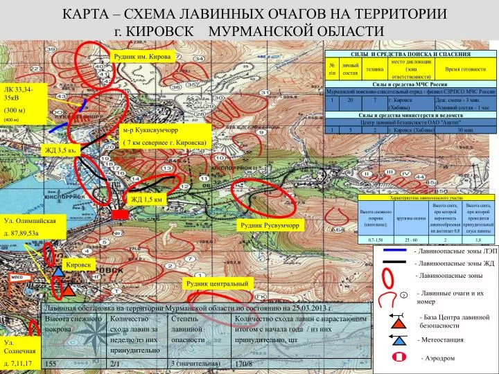
КАРТА – СХЕМА ЛАВИННЫХ ОЧАГОВ НА ТЕРРИТОРИИ г. КИРОВСК МУРМАНСКОЙ ОБЛАСТИ. С. З. В. Ю. МПСО. Рудник им. Кирова. ЛК 33,34-35кВ (300 м). Л 181-110кВ (400 м). м-р Кукисвумчорр ( 7 км севернее г. Кировска). ЖД 3,5 км. ЖД 1,5 км. Ул. Олимпийская д. 87,89,53а. Рудник Русвумчорр.

E N D
КАРТА – СХЕМА ЛАВИННЫХ ОЧАГОВ НА ТЕРРИТОРИИ • г. КИРОВСК МУРМАНСКОЙ ОБЛАСТИ С З В Ю МПСО Рудник им. Кирова ЛК 33,34-35кВ (300 м) Л 181-110кВ (400 м) м-р Кукисвумчорр ( 7 км севернее г. Кировска) ЖД 3,5 км ЖД 1,5 км Ул. Олимпийская д. 87,89,53а Рудник Русвумчорр Кировск Условные обозначения - Лавиноопасные зоны ЛЭП - Лавиноопасные зоны ЖД Рудник центральный - Лавиноопасные зоны - Лавинные очаги и их номер 7 Ул. Солнечная д. 7,11,17 - База Центра лавинной безопасности - Метеостанция - Аэродром
ХАРАКТЕРИСТИКИ • ГОРНОЛЫЖНЫХ СПУСКОВ МУРМАНСКОЙ ОБЛАСТИ