Download
1 / 1
30 likes | 298 Views
Gengsheng Liang Dr. Darka Mioc Dr. Fran ç ois Anton. Background Geographical Information System provides enough information for emergency managers to implement ground rescue. Information on ground rescue focuses on Time, Security, and Distribution. Implementation flow.

E N D
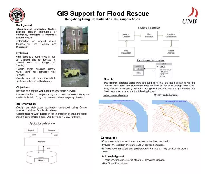
Gengsheng Liang Dr. Darka Mioc Dr. François Anton • Background • Geographical Information System provides enough information for emergency managers to implement ground rescue. • Information on ground rescue focuses on Time, Security, and Distribution. Implementation flow GIS Support for Flood Rescue Road network data model Results Two different shortest paths were retrieved in normal and flood situations via the Internet. Both paths are safe routes because they do not pass through flood area. They can help emergency managers and general public to make a right decision for flood rescue. An example is the following figures, Objectives Develop an adaptive web-based transportation network that enables flood managers and general public to make a timely and available decision for ground rescue under emergency situation. Problems The topology of road networks can be changed due to damage to several roads and bridges by flooding. People might obtained unsafe routes using non-obstructed road networks. People can not determine which roads are safe during flood event. Under flood situations Under normal situations • Implementation • Design an Web_based application developed using Oracle network model and Oracle MapViewer. • Update road network based on the intersection of links and flood area by using Oracle Spatial Operator and PL/SQL functions. Application architecture • Conclusions • Creates an adaptive web-based application for flood evacuation. • Provides the shortest and safe route under flood situation. • Enables flood managers and general public to make a timely decision for ground rescue. • Acknowledgment • GeoConnections Secretariat of Natural Resource Canada • The City of Fredericton