Download
1 / 1
10 likes | 77 Views
Using CALIPSO to Explore the Sensitivity to Cirrus Height in the Infrared Observations from NPOESS/VIIRS and GOES-R/ABI. Andrew Heidinger (GOVERNMENT PRINCIPAL INVESTIGATOR) NOAA/NESDIS/STAR/CoRP/ASPB.

E N D
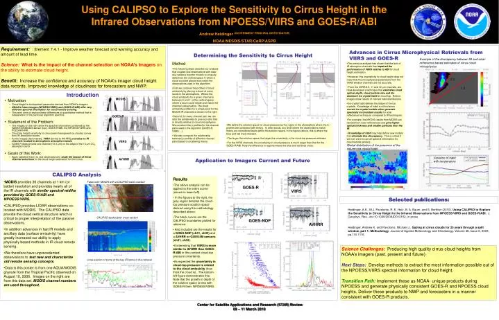
Using CALIPSO to Explore the Sensitivity to Cirrus Height in the Infrared Observations from NPOESS/VIIRS and GOES-R/ABI Andrew Heidinger (GOVERNMENT PRINCIPAL INVESTIGATOR) NOAA/NESDIS/STAR/CoRP/ASPB Requirement:: Element 7.4.1 - Improve weather forecast and warning accuracy and amount of lead time. Science: What is the impact of the channel selection on NOAA’s imagers on the ability to estimate cloud height. Benefit: Increase the confidence and accuracy of NOAA’s imager cloud height data records. Improved knowledge of cloudiness for forecasters and NWP. Determining the Sensitivity to Cirrus Height Advances in Cirrus Microphysical Retrievals from VIIRS and GOES-R Example of the discrepancy between IR and solar-reflectance based estimates of cirrus cloud microphysics 2:1 • Method • The following steps describe our analysis that couples real observations with clear-sky radiative transfer models to uniquely determine the vertical space in which a cloud could be placed and match the observations used in the algorithm. • First we compute the profiles of cloud emissivity by placing a cloud at many levels in the atmosphere. Where the cloud emissivity for a given channel is between 0 and 1, is the vertical space where a cloud could reside and match the channel’s observation. The cloud emissivity profiles for a single pixel for the MODIS IR channels is shown to the right. • Second, for every channel pair, we can ratio the emissivities to give a b-ratio that is directly relative to cloud microphysics. We construct the b-profiles for the channel pairs used in the algorithm (GOES-R, VIIRS …) • We also compute the relationship between b-profiles of different channel pairs based on scattering theory. • The previous analysis has shown that the lack of IR absorption channels has impaired the performance of VIIRS relative to ABI for cloud height estimation. • However, this insensitivity to cloud height does not mean that the microphysical parameters from the VIIRS window channels are not accurate. • From the VIIRS 8.5, 11 and 12 mm channels, we have developed a technique that estimates cloud optical depth, cloud particle size and the dominant ice crystal habit at cloud-top. Bottom images show results of inferred habit distributions. • Ice crystal habit defines the shape of the ice crystals. Knowledge of habit is critical since current ice crystal models often generate spectrally inconsistent results for solar reflectance techniques compared to IR techniques. • For example, the MYD06 results from MODIS are derived from solar reflectances and give higher optical thickness and smaller particles than the IR. • Knowledge of habit may help define new models that eliminate this discrepancy. This is critical if we ever want to use all spectral information for cloud remote sensing. 1:1 Introduction MODIS • Motivation • Cloud height is an important parameter derived from NOAA’s imagers. • NOAA’s future images (NPOESS/VIIRS) and (GOES-R/ABI) offer very different spectral information for cloud remote sensing. • This work aims to explore these differences in quantitative method that is independent of the particular algorithm specifics. • Statement of the Problem: • The images on the right show the spectral information contained by the NASA EOS/MODIS sensor (top), GOES-R/ABI, the NPOESS/VIIRS and POES/AVHRR. • Cloud top height sensitivity to cirrus (semi-transparent ice clouds) comes from IR absorption bands. • As the images demonstrate, VIIRS(similar to AVHRR)provides no IR channels located in atmospheric absorption bands. • GOES-R does provide one channel (13.3 mm) on the edge of the 14 mm CO2 absorption band. • Goals of this Work: • Apply radiative theory to real observations to study the impact of these channel selections on the cloud height estimation for thin cirrus. GOES-R • We define the solution space for cloud-pressure as the region in the atmosphere where the b-profiles are consistent with theory. In other words, any level where the observations match theory are considered levels within the solution space. In the figures above, this is where the blue and red lines intersect. • The larger the solution space, the larger the uncertainty in the cloud-top pressure estimate. • For the VIIRS channels, the uncertainty in cloud pressure is much larger than that for the GOES-R/ABI. Note the difference in regions where the blue and red lines cross. VIIRS Global distribution of the presence of the column ice crystal habit Application to Imagers Current and Future Variation of habit with temperature AVHRR CALIPSO Analysis • Results • The above analysis can be applied to the entire scene (shown in lower left). • In the figures to the right, the grey region denotes the cloud-top pressure solution space derived using the methodology described above. • The black curves are the CALIPSO boundaries plotted for reference. • Also included are the results for a GOES-NOP (ch31, ch33) and a AVHRR or GOES-IM sensors (ch31, ch32). • It interesting that VIIRS is more similar to AVHRR than GOES-R/ABI in this context cloud-top pressure uncertainty. • As expected the uncertainty in cloud-top pressure is related to the cloud emissivity (how thick the cloud is). The bottom-left figure demonstrates this. Note that the growth in depth of the solution space is less with GOES-R then NPOESS/VIIRS. • MODIS provides 36 channels at 1 km (or better) resolution and provides nearly all of the IR channels with similar spectral widths provided by GOES-R/ABI and NPOESS/VIIRS. • CALIPSO provides LIDAR observations co-located with MODIS. The CALIPSO data provide the cloud vertical structure which is critical to proper interpretation of the passive observations. • In addition advances in fast IR models and ancillary data (surface emissivity) have greatly increased our ability to apply physically based methods in IR cloud remote sensing. • We therefore have unprecedented observations to test new and characterize old remote sensing concepts. • Data is this poster is from one AQUA/MODIS granule from the Tropical Pacific observed on August 10, 2006. Images on the right are from this data set. MODIS channel numbers are used throughout. False color MODIS with a CALIPSO track overlaid GOES-R VIIRS Selectedpublications: Heidinger, A.K., M.J. Pavolonis, R. E. Holz, B. A. Baum, and S. Berthier (2010), Using CALIPSO to Explore the Sensitivity to Cirrus Height in the Infrared Observations from NPOESS/VIIRS and GOES-R/ABI, J. Geophys. Res., doi:10.1029/2009JD012152, in press Heidinger, Andrew K. and Pavolonis, Michael J.. Gazing at cirrus clouds for 25 years through a split window, part 1: Methodology. Journal of Applied Meteorology and Climatology, Volume 48, Issue 6, 2009, pp.110-1116. CALIPSO backscatter cross-section GOES-NOP AVHRR Science Challenges: Producing high quality cirrus cloud heights from NOAA’s imagers (past, present and future) Next Steps:Develop methods to extract the most information possible out of the NPOESS/VIIRS spectral information for cloud height. Transition Path: Implement these as NOAA- unique products during NPOESS and generate physically consistent GOES-R and NPOESS cloud heights. Deliver these products to NWP and forecasters in a manner consistent with GOES-R products. cross-section of some of the key IR terms in the retrieval