Download
1 / 48
480 likes | 484 Views
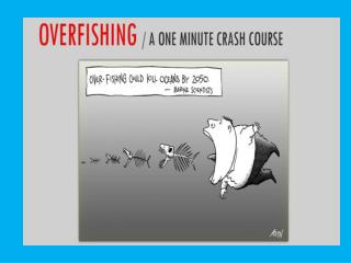
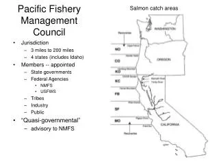
“The early decades of the canning industry in the Pacific Northwest can be described as nothing less than an all-out attack on salmon”. Lichatowich 1999:111. “Fishery Failure” Declared for West Coast Salmon Fishery Declaration Clears Path for Congressional Action

E N D
“The early decades of the canning industry in the Pacific Northwest can be described as nothing less than an all-out attack on salmon”. Lichatowich 1999:111 “Fishery Failure” Declared for West Coast Salmon Fishery Declaration Clears Path for Congressional Action Secretary of Commerce Carlos M. Gutierrez today declared a commercial fishery failure for the West Coast salmon fishery due to historically low salmon returns. Also today, NOAA’s Fisheries Service issued regulations to close or severely limit recreational and commercial salmon fishing in the area. “The unprecedented collapse of the salmon population will hit fishermen, their families, and fishing communities hard, and that is why we have moved quickly to declare a fishery disaster,” Gutierrez said. “Our scientists are working to better understand the effects that ocean changes have on salmon populations. We are also working closely with fishing communities to improve salmon habitat in river systems to support sustainable fishing.”
Chapter #5Ecosystems and the Physical Environmentpg. 88 - 112
Readings last Week and this Week: Chapter #5 – “Free Wealth” Facilitators: Labecca Hampton and Jessica Vidal Chapter #6 – “Cultivate the Waters” Facilitators: Patrick Grennan and Scott Arnold
Solar Radiation • Sun provides energy for life, powers biogeochemical cycles, and determines climate • 69% of incoming solar radiation is absorbed by atmosphere and earth • Remainder is reflected • Albedo • The reflectance of solar energy off earth’s surface • Dark colors = low albedo • Forests and ocean • Light colors = high albedo • Ice caps
Temperature Changes with Latitude • Solar energy does not hit earth uniformly • Due to earth’s spherical shape and tilt Equator (a) High concentration Little Reflection High Temperature Closer to Poles (c) Low concentration Higher Reflection Low Temperature From (a) to (c) In diagram below
Temperature Changes with Season • Seasons determined by earth’s tilt (23.5°) • Causes each hemisphere to tilt toward the sun for half the year • Northern Hemisphere tilts towards the sun from March 21- September 22 (warm season)
The Atmosphere • Invisible layer of gases that envelopes earth • Content • 21% Oxygen • 78% Nitrogen • 1% Argon, Carbon dioxide, Neon and Helium • Density decreases with distance from earth • Shields earth from high energy radiation
Atmospheric Layers • Troposphere (0-10km) • Where weather occurs • Temperature decreases with altitude
Atmospheric Layers • Stratosphere (10-45km) • Temperature increases with altitude- very stable • Ozone layer absorbs UV
Atmospheric Layers • Mesosphere (45-80km) • Temperature decreases with altitude
Atmospheric Layers • Thermosphere (80-500km) • Gases in thin air absorb x-rays and short-wave UV radiation = very hot • Source of aurora
Atmospheric Layers • Exosphere (500km and up) • Outermost layer • Atmosphere continues to thin until converges with interplanetary space
Atmospheric Circulation • Near Equator • Warm air rises, cools and splits to flow towards the poles • ~30°N&S sinks back to surface • Air moves along surface back towards equator • This occurs at higher latitudes as well • Moves heat from equator to the poles
Surface Winds • Large winds due in part to pressures caused by global circulation of air • Left side of diagram • Winds blow from high to low pressure • Right side of diagram High Low High Low High Low High
Coriolis Effect • Earth’s rotation influences direction of wind • Earth rotates from East to West • Deflects wind from straight-line path • Coriolis Effect • Influence of the earth’s rotation on movement of air and fluids • Turns them Right in the Northern Hemisphere • Turns them Left in the Southern Hemisphere
Coriolis Effect • Visualize it as a Merry-Go-Round (see below)
Global Ocean Circulation • Prevailing winds produce ocean currents and generate gyres • Example: the North Atlantic Ocean • Trade winds blow west • Westerlies blow east • Creates a clockwise gyre in the North Atlantic • Circular pattern influenced by coriolis effect
Position of Landmasses Large landmasses in the Northern Hemisphere help to dictate ocean currents and flow Very little land in the Southern Hemisphere
Ocean Interaction with Atmosphere- ENSO • El Niño-Southern Oscillation (ENSO) • Definition: periodic large scale warming of surface waters of tropical eastern Pacific Ocean • Alters ocean and atmospheric circulation patterns • Normal conditions- westward blowing tradewinds keep warmest water in western Pacific • ENSO conditions- trade winds weaken and warm water expands eastward to South America • Big effect on fishing industry off South America
Weather and Climate • Weather • The conditions in the atmosphere at a given place and time • Temperature, precipitation, cloudiness, etc. • Climate • The average weather conditions that occur in a place over a period of years • 2 most important factors: temperature and precipitation • Earth as many climates
Rain Shadows • Mountains force humid air to rise • Air cools with altitude, clouds form and precipitation occurs (windward side) • Dry air mass moves down opposite leeward side of mountain
Tornadoes • Powerful funnel of air associated with a severe thunderstorm • Formation • Mass of cool dry air collides with warm humid air • Produces a strong updraft of spinning air under a cloud • Spinning funnel becomes tornado when it descends from cloud • Wind velocity= up to 300mph • Width ranges from 1m to 3.2km
Tropical Cyclone • Giant rotating tropical storms • Wind >119km per hour • Formation • Strong winds pick up moisture over warm surface waters • Starts to spin due to Earth’s rotation • Spin causes upward spiral of clouds • Damaging on land • High winds • Storm surges
Biogeochemical Cycles • Matter (elements) moves between ecosystems, biotic & abiotic environments, and organisms • Unlike energy • Biogeochemical cycling involves: • Biological, geologic and chemical interactions • Five major cycles: • Carbon, Nitrogen, Phosphorus, Sulfur and Water (hydrologic)
The Carbon Cycle x 1015g of Carbon
The Nitrogen Cycle x 1012g of Nitrogen Nitrate NO3 Nitrite NO2- Ammonia NH3 Ammonium NH4+
The Phosphorus Cycle x 1012g of Phosphorus
The Sulfur Cycle x 1012g of Sulfur
The Water (Hydrologic) Cycle km3 year
Internal Planetary Processes • Layers of the earth • Lithosphere • Outermost rigid rock layer composed of plates • Asthenosphere • Lower mantle comprised of hot soft rock • Plate Tectonics- study of the processes by which the lithospheric plates move over the asthenosphere • Plate Boundary- where 2 plates meet • Common site of earthquakes and volcanoes
Types of Plate Boundaries • Divergent Plate Boundary-2 plates move apart • Convergent Plate Boundary-2 plates move together (may get subduction)
Types of Plate Boundaries • Transform Plate Boundary- 2 plates move horizontally in opposite, parallel directions
Earthquakes • Caused by the release of accumulated energy as rocks in the lithosphere suddenly shift or break • Occur along faults • Energy released as seismic wave • Focus- the site where the earthquake originates below the surface • Epicenter- located on the earth’s surface, directly above the focus • Richter scale and the moment magnitude scales are used to measure the magnitude
Tsunami • Giant undersea wave caused by an earthquake, volcanic eruption or landslide • Travel > 450mph • Tsunami wave may be 1m deep in ocean • Becomes 30.5m high on shore • Magnitude 9.3 earthquake in Indian Ocean • Triggered tsunami that killed over 230,000 people in South Asia and Africa
Human Impacts of Nutrient Cycles • Hubbard Brook Watershed Study • Long term ecological research
Summary • Biogeochemical cycles in which elements are moved • Biogeochemical cycles are composed of reservoirs and pathways. Fluxes between compartments can be measured. • Some elements cycle quickly such as those with a gaseous phase. • Some cycles are internal with an ecosystem • Ecosystems can lose nutrients and be deposited elsewhere. • Humans can have an impact on nutrient cycling.