Download
1 / 13
130 likes | 274 Views
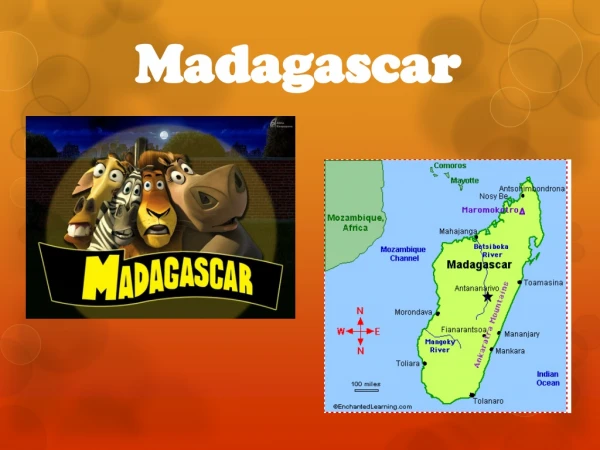
IDENTIFICATION OF THE IDEAL SITES FOR MARINE TURBINE IN MADAGASCAR. Nirilalaina RANDRIATEFISON 1 , Yvon ANDRIANAHARISON 2 1: Ecole Normale Supérieure 2: Ecole Supérieure Polytechnique Université d’Antananarivo, Madagascar. Diego Suarez ( Antsiranana ), located in the Far North

E N D
IDENTIFICATION OF THE IDEAL SITES FOR MARINE TURBINE IN MADAGASCAR Nirilalaina RANDRIATEFISON1, Yvon ANDRIANAHARISON2 1: Ecole Normale Supérieure 2: Ecole Supérieure Polytechnique Université d’Antananarivo, Madagascar RN, HEPMAD 18, Madagascar-Antananarivo (6-11 september 2018)
Diego Suarez (Antsiranana), located in the Far North • Majunga(Mahajanga) in the northwest • Tulear(Toliara) in the southwest • Morondava in the west • And Nosy Be, the coastal island of Madagascar located in the Mozambique Channel Map of Madagascar Source: http://gasykarajia2008.skyrock.com RN, HEPMAD 18, Madagascar-Antananarivo (6-11 september 2018)
Source : Les hydroliennes , Jacques Ruer, SAIPEM , Conférence mer et littoral de Bretagne, HydrolienFromveur, 3 juin 2013 RN, HEPMAD 18, Madagascar-Antananarivo (6-11 september 2018)
In France, in 2017, the company OpenHydro / Naval Group installed 2 tidal turbines (with a diameter of 16m and a cumulative power of 1 MW), bay of Saint Brieuc, Source: Photos d’archives Le Télégramme • " Marine Energy Action Plan 2010" aims: • to save 17 million tons of CO2 by 2030 and 60 million tons by 2050, • creating 16,000 jobs The United Kingdom RN, HEPMAD 18, Madagascar-Antananarivo (6-11 september 2018)
Main forms of capturing this energy : • transformation of the kinetic energy of marine currents, including tidal currents encountered near the coast in the case of the marine turbine here treaty; • use of potential energy related to tidal range (it is the difference of level between full and low tide) by tidal power plants of the Rance type; • use of wave energy from the wind on the surface of the sea (also-called "wave energy") RN, HEPMAD 18, Madagascar-Antananarivo (6-11 september 2018)
The warm currents (in red) The cold currents (in white) • Source : • - www.kolpex.servhome.org • - Razouls C., de Bovée F., Kouwenberg J. et Desreumaux N., 2005-2017. - Diversity and Geographic Distribution of Marine PlanktonicCopepods, CNRS, UPMC RN, HEPMAD 18, Madagascar-Antananarivo (6-11 september 2018)
Source :MEDDE, Dossier de presse, 2013 ; Conférence Institut Coriolis, 2010 • C : the coefficient of the tide • hm : the time of the tide • Vme(hm) et Vve(hm) : speeds RN, HEPMAD 18, Madagascar-Antananarivo (6-11 september 2018)
Source: http://www.morondava-autrement.com Mischief of marine erosion on the coast Source: Razafimbelo M.R. • Protective dam • Abandoned village near to the beach RN, HEPMAD 18, Madagascar-Antananarivo (6-11 september 2018)
A new marine current along Madagascar Source: Ramanantsoa, J. H. D., P. Penven, M. Krug, J. Gula, and M. Rouault, Uncovering a new current: the South-westMAdagascarCoastalCurrent (SMACC), 2018, Geophys. Res. Lett., 45, 2017GL075900 RN, HEPMAD 18, Madagascar-Antananarivo (6-11 september 2018)
The "Edge of Mahajanga “: the most stable zone in normal times during the passage of cycloneHellen in 2014 Source: Mandimbiharison Aurélien RN, HEPMAD 18, Madagascar-Antananarivo (6-11 september 2018) Waves of Nosy Be Island
To be favorable for the installation of this tidal energy equipment, the sites must meet the following criteria: • current greater than 4 or 5 knots; • depth of about 40 meters; • proximity to the coast to pull a submarine cable • =>These criteria met by the cities of the west coast of Madagascar, therefore, the projects of installation of tidal turbines are favorable. RN, HEPMAD 18, Madagascar-Antananarivo (6-11 september 2018)
The equation of continuity Sn • Wind Sm Sl H d • Bathymetry The Navier-Stokes equations • H: Height of total water of it (m) • d : Rating of the bathymetry in relation to the middle level • : Variations of the free surface • Tidal database: • the height, • the period, • the pressure, • wave direction, in addition to measuring currents. Geometry of the study area RN, HEPMAD 18, Madagascar-Antananarivo (6-11 september 2018)
Honorable audience, Thank you for your attention RN, HEPMAD 18, Madagascar-Antananarivo (6-11 september 2018)