Download

1 / 48
480 likes | 575 Views
EOY Revision. Form 4- Geography. The difference between the maximum and minimum temperatures recorded for a place during a period of one day is called daily mean temperature diurnal temperature range mean monthly temperature mean annual temperature.

E N D
EOY Revision Form 4- Geography
The difference between the maximum and minimum temperatures recorded for a place during a period of one day is called • daily mean temperature • diurnal temperature range • mean monthly temperature • mean annual temperature
A line on a weather map joining all places of equal temperatures is called • Isotherm • Isoyet • Isobar • isohel
Which one of the following BEST explains why there is a narrow belt of heavy rain on each side of the cold front of a depression? • The cold air is forced to rise by the warm air undercutting it. • The warm air is forced to rise by the cold air undercutting air. • Cold air rises contains more water vapour than warm air. • Winds are strongest at the cold front.
Isobars on a map which are close together indicate • an increase in wind speed • a decrease in wind speed • a change in wind direction • no change in pressure
Where would you site an anemometer to obtain accurate readings? • In a Stevenson Screen. • In a well ventilated room. • High above the ground in an open place. • Near the ground in an open place.
The amount of heat received at any part of the earth’s surface is determined mainly by its • Latitude • Longitude • relief features • cloud cover.
The natural vegetation of the equatorial forest is tall because • it is hot and wet all the year round. • The trees have long roots- as much as 10 metres. • They shelter the young trees from the hot sun. • Felling is controlled by the government.
8. “ These clouds are over 9000 metres in height. Their black and white globular masses take a fantastic range of shapes. This is frequently seen in tropical afternoons. They are also referred to as thunder-clouds.” Which one of the following are the statements referring to? • Stratus • Cumulonimbus • Cirrus • Altostratus
The mean annual rainfall of equatorial regions is about • 1 500 mm • 2 000 mm • 2 500 mm • 3 000 mm
The word “monsoon” refers to • a marked seasonal rainfall. • A marked seasonal change of wind direction. • A particular summer wind direction. • A particular winter wind direction.
11. India experiences an inter-monsoonal period during the months from _______ to _____. • November, January. • March, May. • June, august. • September, November.
Which one of the following is NOT a weather element? • Rainfall • cloud cover • Latitude • fog
Warm frontal rain is experienced when • a mass of cold air moves into an area of warm air. • A mass of warm air moves into an area of cold air. • The land is heated until it is very hot. • The wind moves to the leeward side of the mountain.
The tropical monsoon type of climate is best represented by • Japan. • China • India • Australia
In the northern hemisphere, ________ receive a greater concentration of solar radiation and are usually warmer. • North-facing slope. • South-facing slope. • East-facing slope. • West-facing slope.
Equatorial lowlands usually experience • a large diurnal range of temperature. • Heavy thunder rain in the afternoon. • Strong winds • Cold nights.
What type of climate is said to have a ‘mild, wet winters and hot, dry summers with a moderate rainfall? • Tropical Monsoon Climate. • Central Continental Siberian Climate. • Warm Temperate Mediterranean Climate. • Cool Temperate Climate.
18. An equatorial forest may contain all of the following trees EXCEPT • Ebony • Iron wood • Meranti • Acacia
The relative humidity of the air is measured by using readings from • wet and dry bulb thermometers. • A rain gauge. • Barometers. • Maximum and minimum thermometers.
Rain falls because • Clouds bump into mountains and so burst. • Moist air rises and condenses. • Clouds become too cold to hold water. • Clouds bump into each other and so burst.
Study the instruments and fill in the blanks. 1 • ___________ • ___________ • ___________ 4. ___________ 2 3 4 Name of Instrument: ___________________________
1. ___________________ 2.___________________ 3. ___________________ 4. ___________________ Name of Instrument: _________________________
Y X Z W Name of Instrument: _________________________
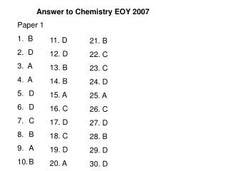
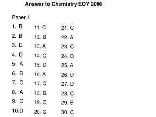
ANSWERS Form 4- Geography
The difference between the maximum and minimum temperatures recorded for a place during a period of one day is called • daily mean temperature • diurnal temperature range • mean monthly temperature • mean annual temperature Answer : B
A line on a weather map joining all places of equal temperatures is called • Isotherm • Isoyet • Isobar • isohel Answer : A
Which one of the following BEST explains why there is a narrow belt of heavy rain on each side of the cold front of a depression? • The cold air is forced to rise by the warm air undercutting it. • The warm air is forced to rise by the cold air undercutting air. • Cold air rises contains more water vapour than warm air. • Winds are strongest at the cold front. Answer : B
Isobars on a map which are close together indicate • an increase in wind speed • a decrease in wind speed • a change in wind direction • no change in pressure Answer : A
Where would you site an anemometer to obtain accurate readings? • In a Stevenson Screen. • In a well ventilated room. • High above the ground in an open place. • Near the ground in an open place. Answer : C
The amount of heat received at any part of the earth’s surface is determined mainly by its • Latitude • Longitude • relief features • cloud cover. Answer : A
The natural vegetation of the equatorial forest is tall because • it is hot and wet all the year round. • The trees have long roots- as much as 10 metres. • They shelter the young trees from the hot sun. • Felling is controlled by the government. Answer : A
8. “ These clouds are over 9000 metres in height. Their black and white globular masses take a fantastic range of shapes. This is frequently seen in tropical afternoons. They are also referred to as thunder-clouds.” Which one of the following are the statements referring to? • Stratus • Cumulonimbus • Cirrus • Altostratus Answer : B
The mean annual rainfall of equatorial regions is about • 1 500 mm • 2 000 mm • 2 500 mm • 3 000 mm Answer : C
The word “monsoon” refers to • a marked seasonal rainfall. • A marked seasonal change of wind direction. • A particular summer wind direction. • A particular winter wind direction. Answer : B
11. India experiences an inter-monsoonal period during the months from _______ to _____. • November, January. • March, May. • June, august. • September, November. Answer : B
Which one of the following is NOT a weather element? • Rainfall • cloud cover • Latitude • fog Answer : C
Warm frontal rain is experienced when • a mass of cold air moves into an area of warm air. • A mass of warm air moves into an area of cold air. • The land is heated until it is very hot. • The wind moves to the leeward side of the mountain. Answer : B
The tropical monsoon type of climate is best represented by • Japan. • China • India • Australia Answer : C
In the northern hemisphere, ________ receive a greater concentration of solar radiation and are usually warmer. • North-facing slope. • South-facing slope. • East-facing slope. • West-facing slope. Answer : B
Equatorial lowlands usually experience • a large diurnal range of temperature. • Heavy thunder rain in the afternoon. • Strong winds • Cold nights. Answer : B
What type of climate is said to have a ‘mild, wet winters and hot, dry summers with a moderate rainfall? • Tropical Monsoon Climate. • Central Continental Siberian Climate. • Warm Temperate Mediterranean Climate. • Cool Temperate Climate. Answer : C
18. An equatorial forest may contain all of the following trees EXCEPT • Ebony • Iron wood • Meranti • Acacia Answer : D
The relative humidity of the air is measured by using readings from • wet and dry bulb thermometers. • A rain gauge. • Barometers. • Maximum and minimum thermometers. Answer : A
Rain falls because • Clouds bump into mountains and so burst. • Moist air rises and condenses. • Clouds become too cold to hold water. • Clouds bump into each other and so burst. Answer : C
Study the instruments and fill in the blanks. 1 • OUTER CASING • FUNNEL • COPPER CYLINDER 4. GLASS BOTTLE 2 3 4 Name of Instrument: RAIN GAUGE
1. VACUUM 2.ALCOHOL 3. METAL INDEX 4. MERCURY Name of Instrument: SIX’S THERMOMETER
Spoke Cup Vertical spindle Electrically operated dial Name of Instrument: An anemometer