Download
1 / 36
360 likes | 367 Views
This overview explores the concepts of ellipsoid, geoid, datum, projection, and coordinate systems in mapping the Earth's surface onto a flat plane. Learn about different datums, projections, and the mathematical relationships that govern them.

E N D
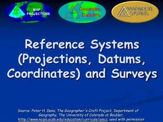
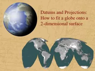
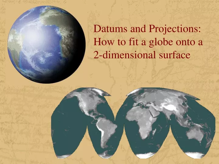
Datums and Projections:How to fit a globe onto a 2-dimensional surface
Overview • Ellipsoid • Spheroid • Geoid • Datum • Projection • Coordinate System
Definitions: Ellipsoid • Also referred to as Spheroid, although Earth is not a sphere but is bulging at the equator and flattened at the poles • Flattening is about 21.5 km difference between polar radius and equatorial radius • Ellipsoid model necessary for accurate range and bearing calculation over long distances GPS navigation • Best models represent shape of the earth over a smoothed surface to within 100 meters
Geoid: the true 3-D shape of the earth considered as a mean sea level extended continuously through the continents • Approximates mean sea level • WGS 84 Geoid defines geoid heights for the entire earth
Definition: Datum • A mathematical model that describes the shape of the ellipsoid • Can be described as a reference mapping surface • Defines the size and shape of the earth and the origin and orientation of the coordinate system used. • There are datums for different parts of the earth based on different measurements • Datums are the basis for coordinate systems • Large diversity of datums due to high precision of GPS • Assigning the wrong datum to a coordinate system may result in errors of hundreds of meters
Commonly used datums GPS is based on WGS 84 system GRS 1980 and WGS 84 define the earth’s shape by measuring and triangulating from an outside perspective, origin is earth’s center of mass
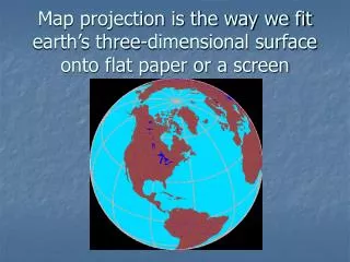
Projection • Method of representing data located on a curved surface onto a flat plane • All projections involve some degree of distortion of: • Distance • Direction • Scale • Area • Shape • Determine which parameter is important • Projections can be used with different datums
Projections • The earth is “projected” from an imaginary light source in its center onto a surface, typically a plate, cone, or cylinder. Planar or azimuthal Conic Cylindrical
Other Projections Pseudocylindrical Unprojected or Geographic projection: Latitude/Longitude There are over 250 different projections!
Tangency: only one point touches surface Cylindrical: used for entire world parallels and meridians form straight lines Secancy: projection surface cuts through globe, this reduces distortion of larger land areas
Cylindrical projection Shapes and angles within small areas are true (7.5’ Quad) Distances only true along equator
Conical: can only represent one hemisphere often used to represent areas with east-west extent (US)
Albers is used by USGS for state maps and all US maps of 1:2,500,000 or smaller 96 degrees W is central meridian Lambert is used in State Plane Coordinate System Secant at 2 standard parallels Distorts scale and distance, except along standard parallels Areas are proportional Directions are true in limited areas
Azimuthal: Often used to show air route distances Distances measured from center are true Distortion of other properties increases away from the center point
Orthographic: Used for perspective views of hemispheres Area and shape are distorted Distances true along equator and parallels Lambert: Specific purpose of maintaining equal area Useful for areas extending equally in all directions from center (Asia, Atlantic Ocean) Areas are in true proportion Direction true only from center point Scale decreases from center point
Pseudocylindrical: Used for world maps Straight and parallel latitude lines, equally spaced meridians Other meridians are curves Scale only true along standard parallel of 40:44 N and 40:44 S Robinson is compromise between conformality, equivalence and equidistance
Mathematical Relationships • Conformality • Scale is the same in every direction • Parallels and meridians intersect at right angles • Shapes and angles are preserved • Useful for large scale mapping • Examples: Mercator, Lambert Conformal Conic • Equivalence • Map area proportional to area on the earth • Shapes are distorted • Ideal for showing regional distribution of geographic phenomena (population density, per capita income) • Examples: Albers Conic Equal Area, Lambert Azimuthal Equal Area, Peters, Mollweide)
Mathematical Relationships • Equidistance • Scale is preserved • Parallels are equidistantly placed • Used for measuring bearings and distances and for representing small areas without scale distortion • Little angular distortion • Good compromise between conformality and equivalence • Used in atlases as base for reference maps of countries • Examples: Equidistant Conic, Azimuthal Equidistant • Compromise • Compromise between conformality, equivalence and equidistance • Example: Robinson
Projections and Datums • Projections and datums are linked • The datum forms the reference for the projection, so... • Maps in the same projection but different datums will not overlay correctly • Tens to hundreds of meters • Maps in the same datum but different projections will not overlay correctly • Hundreds to thousands of meters.
Coordinate System • A system that represents points in 2- and 3- dimensional space • Needed to measure distance and area on a map • Rectangular grid systems were used as early as 270 AD • Can be divided into global and local systems
Geographic coordinate system • Global system • Prime meridian and equator are the reference planes to define spherical coordinates measured in latitude and longitude • Measured in either degrees, minutes, seconds, or decimal degrees (dd) • Often used over large areas of the globe • Distance between degrees latitude is fairly constant over the earth • 1 degree longitude is 111 km at equator, and 19 km at 80 degrees North
Universal Transverse Mercator • Global system • Mostly used between 80 degrees south to 84 degrees north latitude • Divided into UTM zones, which are 6 degrees wide (longitudinal strips) • Units are meters
Eastings are measured from central meridian (with 500 km false easting for positive coordinates) Northing measured from the equator (with 10,000 km false northing) Easting 447825 (6 digits) Northing 5432953 (7 digits)
State Plane Coordinate System • Local system • Developed in the ’30s, based on NAD27 • Provide local reference systems tied to a national datum • Units are feet • Some larger states have several zones • Projections used vary depending on east-west or north-south extent of state
Which tic marks belong to which grid? • Each of the three coordinate systems (Lat/Long, UTM, and SPCS) have their own set of tick marks on 7½ minute quads: • Lat/Long tics are black and extend in from the map collar • UTM tic marks are blue and 1000 m apart • SPCS tics are black, extend out beyond the map collar, and are 10,000 ft apart
Other systems • Global systems • Military grid reference system (MGRS) • World geographic reference system (GEOREF) • Local systems • Universal polar stereographic (UPS) • National grid systems • Public land rectangular surveys (township and sections)
Determining datum or projection for existing data • Metadata • Data about data • May be missing • Header • Opened with text editor • Software • Some allow it, some don’t • Comparison • Overlay may show discrepancies • If locations are approx. 200 m apart N-S and slightly E-W, southern data is in NAD27 and northern in NAD83
Selecting Datums and Projections • Consider the following: • Extent: world, continent, region • Location: polar, equatorial • Axis: N-S, E-W • Select Lambert Conformal Conic for conformal accuracy and Albers Equal Area for areal accuracy for E-W axis in temperate zones • Select UTM for conformal accuracy for N-S axis • Select Lambert Azimuthal for areal accuracy for areas with equal extent in all directions • Often the base layer determines your projections
Summary • There are very significant differences between datums, coordinate systems and projections, • The correct datum, coordinate system and projection is especially crucial when matching one spatial dataset with another spatial dataset.