Download
1 / 35
350 likes | 354 Views
Explore the Kincaid Dune in Anchorage, AK where climate, mountains, glaciers, erosion & deposition, and human impact shape the landscape. Discover how dunes are formed, move, and are affected by human activities.

E N D
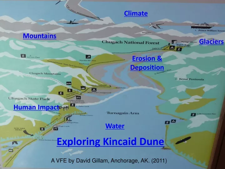
Climate Mountains Glaciers Erosion & Deposition Human Impact Water Exploring Kincaid Dune A VFE by David Gillam, Anchorage, AK. (2011)
Where is the dune located? If you look near where Cook Inlet and Turnagain Arm meet on a point in west Anchorage you will find it.
Kincaid Dune-Anchorage, AK. The Kincaid Dune is a cliff-head dune.
Sediments formed of silty loess and sand. What processes formed these sediments?
Edge of the bluff drops down to Cook Inlet about 20 km below. Why do you think this would be called a cliff-head dune?
Looking to the east towards the Chugach Mountains Sediments are moved by streams that feed into Turnagain Arm. The streams carry sediment formed by glaciers in the mountains. During extreme tides this area fills with water.
Rivers of Ice Glaciers formed over thousands of years and are often called rivers of ice since they are always moving. The movement of the ice grids the rock that it flows over.
Portage Valley and its glaciers contributes sediments to Turnagain Arm. Melt water from glaciers move sediments to Turnagain Arm.
Wind Direction Affects Movement The winds move sand grains on a windy day. The winds usually blow from the west down Turnagain Arm.
How does the sand move? Transport of particles takes place in 3 ways. These are defined by particle size. These are suspension, saltation, and creep.
What is suspension? Small particles under 0.2 millimeters is diameter are held aloft. They can be held aloft indefinitely. Winds blowing across the braided areas and mud flats near Portage Glacier and Turnagain Arm move to the dune this way.
What is saltation? Saltation lifts sand-sized particles no more than a centimeter above the ground in a series of short hops or skips down wind.
What is creep? During saltatioin particles bump and push larger grains along the surface in a process called creep. This type of movement which can account for as much as 25% of movement across exposed surfaces.
Windward Face of Kincaid dune. The windward face of the dune has a gentle slope.(10-12 degrees) Sand is moved to the top edge of the dune. At the top the sand avalanches down to the angle of repose
Leeward Face of Kincaid Dune (Looking down) Sand slide down the leeward slope which is much steeper(33-34 degrees) till is reaches the angle of repose.
As late as 18,000 years ago most of Southcentral Alaska was covered with glacial ice.
Where do glaciers form? Glaciers form in locations that are cool enough for snow to fall in the winter, but not so warm that it will all melt in the following summers.
Glaciers change overtime. Over time glaciers surge and retreat. (Muir Glacier)
Climate impacts the formation of glaciers. The North Slope of Alaska above the Arctic Circle has few glaciers even though it is very cold. Why don’t glaciers form in this area?
Why aren’t there glaciers in the Brooks Range on the North Slope? Even though it is cold in the winter and cool in the summer the ocean that would provide the moisture for snow is frozen so there is little snow and so no glaciers. There are many glaciers in Southcentral Alaska.
Why does open water year round increase the likelihood of glaciers forming? In areas around Southcentral Alaska warm currents from the Pacific bring moist air to the area year round and moderate summer temperatures.
Weather and Climate How does weather and climate impact Kincaid Dune? Weather is what is happening on a particular day. Climate are the patterns that occur with the weather over time.
Anchorage ANCHORAGE (Northern Cook Inlet, adjacent to Chugach Mountains)Period of record: 4/1/1952 to 12/31/2000 The following 4 pages show climate patterns for various locations in the Anchorage area, including Alyeska/Girdwood near the west end of Turnagain Arm. What patterns do you see?
Elmendorf ELMENDORF AIR FORCE BASE (North side of Anchorage)Period of record: 6/2/1951 to 9/30/1997 Is the average minimum temperature higher/lower in January on Elmendorf or Alyeska?
Glen Alps GLEN ALPS (Gateway to Chugach State Park on the Anchorage Hillside)Period of record: 1/28/1971 to 12/31/2000 What area has the greatest snow depth in May? Would this affect dune formation and movement?
Alyeska ALYESort in Girdwood, south KA (Resof Anchorage on Seward Highway) Period of record: 11/7/1963 to 12/31/2000
The wind generally moves from west to east. Notice snow dunes being formed by prevailing wind. How are snow crystals like sand grains?
Windward face January. What evidence of prevailing winds do you see in the winter?
Bore Tides Tidal bores form when tides move long narrow bays or arms. Turnagain Arm has periodic tidal bores.
Chugach and Kenai Mountains The mountains meet at the end of Turnagain Arm. This forms a low pass that creates winds that are moving the Kincaid Dune.
Human Impact Excavation exposed the sandy loess to the winds from Turnagain Arm. How would the opening of the surface of the cliff affect the dune and its movement?
Dune Face TravisS/Creative Commons Lower Dune Area The lower dune area is used as a motocross course. How would this affect the movement of the dune?
Go and explore the dunes yourself! The picture above is from the Geological Society of America’s Geocache/Earthcache website for Kincaid Dunes. The site explains how you can you explore the dunes and contribute to the Geocache website.