Download
1 / 28
300 likes | 576 Views
Integrated Urban Modeling System for the Community WRF Model: Current Status and Future Plan. Fei Chen, Mukul Tewari, Miao Shiguang,Yubao Liu, Allen Chan, George Bieberbach, Tom Warner: NCAR Hiroyuki Kusaka: University of Tsukuba, Japan. Outline Overview of an urban modeling framework

E N D
Integrated Urban Modeling System for the Community WRF Model: Current Status and Future Plan Fei Chen, Mukul Tewari, Miao Shiguang,Yubao Liu, Allen Chan, George Bieberbach, Tom Warner: NCAR Hiroyuki Kusaka: University of Tsukuba, Japan Outline Overview of an urban modeling framework Examples of applying this modeling system Future work Workshop on Model Urbanization Strategy, Exeter, UK. 3-4 May 2007
Next-Generation Mesoscale Modeling:The Weather Research and Forecasting Model (WRF) Goals: Develop advanced mesoscale forecast and assimilation system and accelerate research advances into operations • Collaborative partnership, principally amongNCAR, NOAA, DoD, FAA, AFWA, and universities. • WRF development conducted by 15 WRF Working Groups. • WRF WG 15: land surface model Composite NEXRAD Radar Valid 6/8/03 12Z 4 km WRF BAMEX realtime 12-h forecast Reflectivity Workshop on Model Urbanization Strategy, Exeter, UK. 3-4 May 2007
Integrated WRF Urban Modeling Framework Surface emission sources Urbanized high-res land data assimilation system (u-HRLDAS) Fine-scale atmospheric analysis (FDDA) urban land use characteristics WRF/Noah/Urban coupled modeling system Computational Fluid Dynamic (CFD) models Transport and Dispersion models Chemistry models Urban decision support systems
Integrate Surface Emission ModelMEGAN: Model of Emissions of Gases and Aerosols from Nature (Guenther 2006) • Global biogenic emissions model • 1 km2 spatial resolution • Predicts emissions of > 50 BVOC (Biogenic Volatile Organic Compounds) Emissioni = AEFi * MEA * WEA * HEA Workshop on Model Urbanization Strategy, Exeter, UK. 3-4 May 2007
The Noah Land Surface Model Natural surface • Noah LSM primarily for NWP, air pollution, and regional hydrology applications • Noah in operational models • NCEP WRF-NMM (June 2006) • AFWA: WRF-ARW (July 2006) • Single layer urban-canopy model (UCM, based on Kusaka 2001) • 2-D urban geometry • Street canyons • Shadowing from buildings and reflection of radiation • Anthropogenic heating • Multi-layer roof, wall and road models Coupled through ‘urban fraction’ Man-made surface
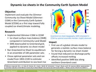
Urbanized high-resolution land data assimilation system (u-HRLDAS) • No routine high-resolution soil and urban observation for initializing WRF/UCM • HRLDAS: Using observations to drive LSMs in uncoupled mode • long term evolution of multi-layer soil moisture, soil temperature, roof/wall/road temperature, surface fluxes, and runoff 4-km HRLDAS surface soil moisture in IHOP domain 12 Z May 29 2002. Chen et al. 2007, J. Appli. Met. Clim. Workshop on Model Urbanization Strategy, Exeter, UK. 3-4 May 2007
u-HRLDAS Spin-up • Both roof and wall temperatures reach equilibrium within a month; roof temperature has fastest spin-up. • However, deep-layer road temperatures still evolve after 30 days. Workshop on Model Urbanization Strategy, Exeter, UK. 3-4 May 2007
Example of u-HRLDAS roof U-HRLDAS simulated spatial distribution of roof, wall, and road surface temperature valid at 1 January 2006 for Houston • Highly dependent on urban types • Reflecting strong heterogeneity in urban environments wall road Workshop on Model Urbanization Strategy, Exeter, UK. 3-4 May 2007
Application of Coupled MM5/WRF Urban Models Beijing and Tokyo: surface weather, precipitation Salt Lake City: Diurnal wind direction (URBAN-2000) Oklahoma City: 2-m temperature (JU-2003) Hong Kong: 10-day surface wind Houston: Diurnal cycle of wind profile (TexAQS-2000) • Liu, Chen, Warner, and Basara: 2006, J Appli. Meteorol. • Lo, Lau, Chen, and Fung, 2007: J. Appli. Meteorol. • Lo, Lau, Fung, and Chen, 2006: J Geophys. Res. • Zhang, Chen, and Miao 2006: J Geophys. Res., in revision. Workshop on Model Urbanization Strategy, Exeter, UK. 3-4 May 2007
Daunting Challenge: Specify fine-scale urban parameters • Urban fraction • building height, ZR • roughness for momentum above the urban canopy layer, Z0C • roughness for heat above the urban canopy layer Z0HC • zero-displacement height above the urban canopy layer, ZDC • percentage of urban canopy, PUC • sky view factor, SVF • building coverage ratio (roof area ratio), R • normalized building height, HGT • drag coefficient by buildings, CDS • buildings volumetric parameter, AS • anthropogenic heat, AH • heat capacity of the roof, wall, and road • heat conductivity of the roof, wall, and road • albedo of the roof, wall, and road • emissivity of the roof, wall, and road • roughness length for momentum of the roof, wall, and road • roughness length for heat of the roof, wall, and road Workshop on Model Urbanization Strategy, Exeter, UK. 3-4 May 2007
Gridded UCM parameters Example of defining urban parameters for Beijing 1, ZR 2, Z0C, Z0HC, ZDC 3, FRC_URB 4, R, RW 5, HGT 6, SVF 7, AS 8, AH: AHB and AHC CDS, BETR, BETB, BETG CAPR, CAPB, CAPG AKSR, AKSB, AKSG ALBR, ALBB, ALBG EPSR, EPSB, EPSG Z0R, Z0B, Z0G, Z0HR, Z0HB, Z0HG UCM parameters assigned from table (urban_param.tbl) Workshop on Model Urbanization Strategy, Exeter, UK. 3-4 May 2007
WRF/Noah/UCM Model for Beijing Study) Workshop on Model Urbanization Strategy, Exeter, UK. 3-4 May 2007
WRF/Noah/UCM Model for Beijing Study Workshop on Model Urbanization Strategy, Exeter, UK. 3-4 May 2007
Sky View Factor (SVF)(45km*36km with 1-km resolution, Min~Max=0.22~1.0 ) 2000 1980s Workshop on Model Urbanization Strategy, Exeter, UK. 3-4 May 2007
AH (Anthropogenic heat) 0800 LST Summer 0800 LST Winter Winter anthropogenic heating is higher than summer Workshop on Model Urbanization Strategy, Exeter, UK. 3-4 May 2007
Diurnal Cycle of AH (Anthropogenic heat) Summer Winter Workshop on Model Urbanization Strategy, Exeter, UK. 3-4 May 2007
Spatial Variance of land surface temperature MODIS Observations WRF/Noah/UCM simulations Workshop on Model Urbanization Strategy, Exeter, UK. 3-4 May 2007
Enhance WRF/UCM global land-use data with high-resolution detailed urban data Aggregated to WRF 1-km domain 30-m Landsat land-cover Houston Workshop on Model Urbanization Strategy, Exeter, UK. 3-4 May 2007
WRF/UCM simulated surface wind rotation in Houston for 25 August 2000 Sea-breeze (largely southerly flow) developed in opposite direction of background wind: Leading to a few hours of weak wind and accumulation of pollutants
WRF/UCM simulation compared to obs from wind profiler at Ellington 25 Aug 2000 PBL depth Workshop on Model Urbanization Strategy, Exeter, UK. 3-4 May 2007
Summary • The coupled WRF/Noah/UCM (single-layer) was released in WRF V2.2 (Dec 2006) • Documentation: http://rap.ucar.edu/research/land/technology/urban.php • Promising to capture fine-scale urban weather phenomena • Integrating other components (new land-use data, surface BVOC emission model, u-HRLDAS, 2-way coupling with CFD model) are in progress. • High-resolution land-use data and initialization systems (u-HRLDAS and FDDA) are critical to improving WRF, T&D, and air quality models. Workshop on Model Urbanization Strategy, Exeter, UK. 3-4 May 2007
Future Work • Conduct uncoupled simulations with different urban models now implemented in WRF • Improve land use data sets • Test and evaluate new model physics in WRF • Collaborating with • Bob Bornstein: SJSU • Jason Ching: US EPA • Bill Coirier: CFDRC • Sue Grimmond: King’s College, UK. • Steve Burian: U. Utah Workshop on Model Urbanization Strategy, Exeter, UK. 3-4 May 2007
Future WorkImprove land-use data from global to urban scalesMODIS vs AVHRR Red: urban areas in the Pearl River Delta, China 1993 USGS data 2001 MODIS data Workshop on Model Urbanization Strategy, Exeter, UK. 3-4 May 2007
(Lowest sigma level) The addition of urban treatment is able to capture the land sea breeze circulation enhanced by urban. Lo, Lau, Chen, and Fung, 2007, JAMC. Magenta :Observation Blue: LSM forecast Yellow: MM5 forecast
Impacts of land-use change on transport and dispersion Simulated by HPAC (primarily through SCIPUFF) Cultivated Nighttime surface dosage Urban More Dispersion Less Advection Workshop on Model Urbanization Strategy, Exeter, UK. 3-4 May 2007
Future Model Development • Test a new k- turbulence parameterization in WRF/UCM with emphasis on stable boundary layer processes (Freedman and Jacobson 2003). • Enhance and test the multi-layer urban canopy model (Martilli-Dupont-EPA, Dupont et al. 2004). Workshop on Model Urbanization Strategy, Exeter, UK. 3-4 May 2007
Incorporating Building Morphological Data for Houston Test Case
Two-way coupling WRF/CFD through MCEL (Model Coupling Environmental Library) CFD-Urban: Hi-Res Urban Model WRF-Noah/UCM coupled model forecast Coupling Down-Scale Up- Scale CFD-Urban: T&D