Download
1 / 22
220 likes | 364 Views
Finding Your Way In the Sky. Term: sky map . The sky map shows the entire sky as viewed from a given location at a specified time and date. A stereographic projection is used, as is the convention for printed star maps. . Coordinates and Time .

E N D
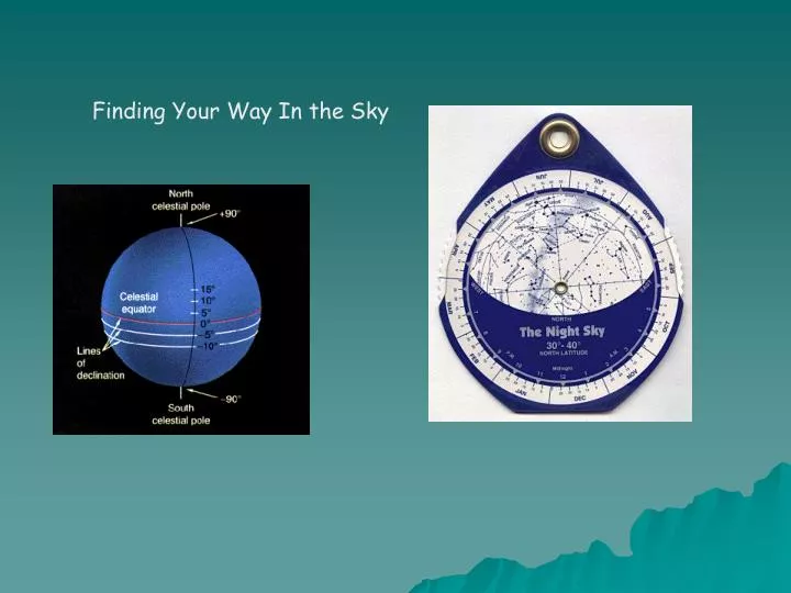
Term: sky map The sky map shows the entire sky as viewed from a given location at a specified time and date. A stereographic projection is used, as is the convention for printed star maps.
Coordinates and Time Astronomical coordinate systems are virtually all spherical coordinate systems; defined by a great circle and its poles. A latitude coordinate measures the angle above or below the circle, a longitude coordinate measures the angle along the circle from some arbitrarily defined point. Terrestrial (latitude/longitude)
The horizon system is a "local" system centered at the individual observer. The great circle is the observer's horizon. The poles of that circle are the zenith (directly overhead) and the nadir. The reference point on the horizon is the north point, defined by a great circle (the meridian) from the zenith through the north celestial pole to the horizon. Extending the meridian in the oposite direction establishes the south point. The east and west points are defined by the intersections of the celestial equator with the horizon.
The latitude coordinate is the altitude (or elevation), measured from the horizon along a great circle running through the zenith. The longitude coordinate is azimuth measured either from the north point increasing towards the east (geographic definition) or from the south point increasing towards the west (astronomical definition). Because of this ambiguity in definition, it is important to determine which form is in use. The geographic definition is most common, even in use by astronomers.
Equatorial (declination/hour angle or declination/right ascension) The Equatorial system is defined by the celestial equator, the projection of the Earth's equator onto to celestial sphere. The poles ore the north celestial pole and the south celestial pole. The reference point is the vernal equinox which is the point where the ecliptic (the apparent path of the sun) crosses the celestial equator with the sun moving towards the summer solstice. The latitude coordinate is declination measured from the celestial equator. The longitude coordinate is right ascension (RA) - measured from the vernal equinox increasing in the direction of the sun's motion; ( 0 <= RA < 24 hours ).
Hour Angle and Right Ascension The introduction of hour angle and right ascension brings us to a transition between coordinates and timekeeping. An observer has a meridian running overhead from north to south. Objects rise in the east, transit the meridian, and set in the west. An object on the celestial equator (declination = 0) takes 12 hours to cross the sky from east to west.
Let's actually build a celestial sphere. First, consider the sky in relation to the earth. Take the north and south poles and extend them into the sky; these become the north and south celestial poles. The earth's equator can be projected outward to form the celestial equator.
Now consider yourself as standing on top of the earth. Your zenith is the point directly above your head; your horizon is a circle perpindicular to the line between you and the zenith, and marks the boundary of the hemisphere of the sky which you can actually see.
Now, to position the celestial poles with respect to your location on the earth, you have to place them at an angle that will match your lattitude. When you're done, you should have a celestial sphere very like the one at the top of this section.
Celestial Coordinates The earth is spinning on its axis once every 24 hours. The axis of the earth is also moving in a circular motion but maintains a constant 23.4° tilt. This in effect makes the earth like a wobbling gyroscope. Compounding things, the earth is also moving around the Sun once a year and the Sun is moving around our galaxy every 220 million years. One more problem, the galaxy is moving through space. In essence everything in the universe is moving constantly in different direction and at different speeds
Because of the slow movement of just about everything in the universe, we can catalog objects in the universe by devising a system that allows us to locate and establish the objects position. Meridian Declination Nadir Right Ascension Alt-Azimuth Celestial Equator Horizon Celestial Pole Angular Measure Altitude Zenith Longitude and Latitude
Angular Measure You will need to know how to specify a direction by angular measure
Angles Astronomy involves thinking about angles--often very tiny, tiny angles. A circle is divided into 360 degrees (or 360°). Each degree is divided into 60 arcminutes (or 60'). Each arcminute can be divided into 60 arcseconds (or 60"). Therefore there are 360x60x60 = 1,296,000 ~ 1.3 x 10⁶ arcminutes in a full circle. Yes, this seems a crazy system and not very `metric'--it goes back to the Babylonians who were hung up on the number 60. No one has been bothered to convince everyone else to make a better system
Since we know the Earth has to rotate completely in 24 hours, and one entire rotation means circling 360°, the rate in degrees that the Earth rotates per hour is: 360 degrees 15 degrees Rotation rate = ------------- = ------------ Or 15° per hour 24 hour hour
There are angles like longitude and latitude on the celestial sphere that describe the location of a star, such as Betelguese. These angles are called Right Ascension and Declination.
1) Go outside and find Polaris and the celestial pole in the night sky. The easiest way is to look roughly north and use the 2 "pointer stars" of the Big Dipper. 2) Point with your left arm to Polaris. Make a right angle to your left arm with your right arm. Your right arm is now pointing to somewhere on the celestial equator. Keeping your left arm pointing to Polaris and your right arm at a rightangle, rotate about your left arm--your right arm will be sweeping out the celestial equator.
(3) Point to the south celestial pole. (4) Look for a bright star (preferable 2 or 3 different ones) that is fairly close to the horizon or an object on the skyline--such as the roof of a house or a tree or a lampost. Note where you are standing, where the star is located and the time. Come back in about 1 hour and note how the stars have moved.