Download
1 / 1
10 likes | 111 Views
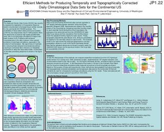
JP1.22. Schematic Diagram for Data Processing of VIC Meteorological Driving Data. PRISM Monthly Precipitation Maps. HCN/HCCD Monthly Data. Topographic Correction for Precipitation. Correction to Remove Temporal Inhomogeneities. Preprocessing Regridding Lapse Temperatures.

E N D
JP1.22 Schematic Diagram for Data Processing of VIC Meteorological Driving Data PRISM Monthly Precipitation Maps HCN/HCCD Monthly Data Topographic Correction for Precipitation Correction to Remove Temporal Inhomogeneities Preprocessing Regridding Lapse Temperatures Coop Daily Data Regridded Raw Coop Precipitation (Annual Mean mm) Regridded HCN/HCCD Precipitation (Annual Mean mm) Efficient Methods for Producing Temporally and Topographically Corrected Daily Climatological Data Sets for the Continental US JISAO/SMA Climate Impacts Group and the Department of Civil and Environmental Engineering, University of Washington Alan F. Hamlet Hyo Seok Park Dennis P. Lettenmaier Data Processing Methods Daily Coop and monthly HCN/HCCD data are first regridded to 1/8th degree latitude/longitude resolution using the Symap algorithm (Shepard 1984). Adjustments are made to the monthly means of the Coop data by comparing smoothed monthly means for each calendar month derived from the Coop data to the analogous time series derived from the USHCN/HCCD data. Daily Coop values are then rescaled so that monthly means match the adjusted monthly means for each month. Finally topographic adjustments (see Maurer et al. 2002) for precipitation are applied to the new daily values for each month. The example shown to the right shows the temporal adjustments to January precipitation values for a cell in the Pacific Northwest domain. Note that the adjusted values are not forced to exactly match the USHCN/HCCD values, but the spurious trends in the Coop data are successfully removed. Overview The National Climatic Data Center (NCDC) has recently completed the digitization of Cooperative Observer station records back to the beginning of written records for the continental US (TD3206 product). The availability of these station data (previously available uniformly over large areas only for 1948-present) offers the opportunity to produce high quality gridded data sets, and in turn hydrologic simulations of large rivers back to about 1915. Problems with temporal inconsistencies in the data, however, have caused problems in hydrologic simulations, especially in the context of trend analysis. We report here on methods for removing these temporal inconsistencies without resorting to extremely labor intensive (or infeasible) corrections to daily time step station data. A schematic of the data processing sequence is shown in the figure below. The methods to remove temporal inconsistencies from raw Cooperative Observer precipitation and temperature data records compare temporally and spatially smoothed gridded data sets based on a) the raw station data and b) a smaller number of high quality stations with long records from the US Historical Climatological Network (USHCN) and Historical Canadian Climate Database (HCCD). After temporal corrections are made, the gridded station data closely reproduce the monthly trends associated with the USHCN and HCCD data, while retaining much of the increased spatial information from the larger number of stations in the Cooperative Observer records. Topographic adjustments to the precipitation data (see Maurer et al. 2002) are then applied. Validation To test the effectiveness of the methods, we compare streamflow simulations from the VIC Hydrologic model version 4.0.4 (Liang et al, 1994; schematic at right) implemented at 1/8th degree resolution over several western basins (see map at right). For the Pacific Northwest domain, simulations before and after temporal corrections are shown. In the Sacremento River basin in CA and in the Colorado River Basin only the long term streamflow simulations (after temporal corrections to the driving data) are shown. Based on the success of these pilot experiments, these methods are being applied to produce temporally and topographically corrected precipitation and temperature data sets for the continental US that will ultimately be used for retrospective hydrologic simulations using the VIC model. These new data sets will also encompass a longer period of record from 1915-2003. Pacific Northwest Domain California Domain Colorado Domain References: Liang, X., Lettenmaier, D.P., Wood, E.F. and Burges, S. J., 1994, A Simple Hydrologically Based Model of Land Surface Water and Energy Fluxes for General Circulation Models, J. Geophys. Res., 99, D7, pp14,415-14,428 Maurer, E.P., A.W. Wood, J.C. Adam, D.P. Lettenmaier, and B. Nijssen, 2002, A long-term hydrologically-based data set of land surface fluxes and states for the conterminous United States, J. Climate. 15, 3237-3251. Shepard, D.S., 1984, Computer mapping: The SYMAP interpolation algorithm, Spatial statistics and Models 133-145, Reidel Publishing Company. Acknowledgments: The authors wish to thank and acknowledge Ned Guttman and colleagues at National Climatic Data Center (NCDC) for their work in processing the TD3206 data set, and for facilitating timely access to the data for this project. Thanks also to Nathalie Voisin at CEE, UW for making preliminary VIC runs in the California and Colorado domains.