Download
1 / 38
420 likes | 546 Views
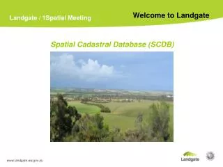
Water Boundaries in Western Australia’s Spatial Cadastral Database (SCDB). Murray Dolling A/Manager, Title Dealings, Landgate Wednesday 27 October 2010. Purpose of the Presentation.

E N D
Water Boundaries in Western Australia’s Spatial Cadastral Database (SCDB) Murray Dolling A/Manager, Title Dealings, Landgate Wednesday 27 October 2010
Purpose of the Presentation To provide an understanding of the way in which water boundaries are represented in the Western Australian Spatial Cadastral Database (SCDB) and the objectives of a research project concerning the consistent determination of High Water Mark. www.landgate.wa.gov.au
Overview • Short history of the SCDB • Types of water boundaries in the SCDB • HWM determination concepts • Description of project – origin, objectives, benefits, issues
What is the SCDB ? • Spatial Cadastral Database • Landgate’s digital cadastral State-wide map. • Comprises topologically related point, line, polygon, angle, azimuth, arc and string constructs as well as land descriptions and tenures, areas, title numbers, addresses and administrative areas.
History of the SCDB • Created in the late 1980’s as a graphic interface tool to retrieve land registration details. • Digitised from the Department’s Public Plan series, using digitizing tablets. • Over 5,500 Public Plans of various scales rangingfrom 1:2000 up to 1:500,000 were digitized. • Point coordinate accuracy achieved was no betterthan 1 mm at map scale, which for example, translates to 2 metres at 1:2000 and 250 metres at 1:250,000.
Portion of a typical Public Plan in a rural area - scale 1:25,000 6
Spatial Upgrade program • Aim is to improve relative and absolute point accuracy. • Process involves replacing digitised dimensions with observed or surveyed measurements and adjusting the position of the points in relation to the geodetic control network. • Accuracies achieved are : New subdivision +/- 0.030m to +/- 0.050m Metro +/- 0.25m Rural +/- 2m Pastoral +/- 10m
Daily Maintenance Landgate maintains the SCDB for : Currency Correctness Completeness Consistency In order to : provide an accurate cadastral framework for use by both internal and external stakeholders, provide an accurate cadastral framework for initiatives such as SLIP, MapViewer, Property Finder, etc., and support its statutory responsibilities for registration and valuation. 8
Day to day activities • SCDB Tasks • Placement of new surveys into the lodged layer • Integration of approved surveys • Spatial upgrade • Tenure maintenance • Data anomaly corrections • Allocate lot numbers to support digital crown title creation • Integration and update of administrative areas • Capture and update of infrastructure easements • Coastline and inland water updates • Road polygon capture www.landgate.wa.gov.au
Drivers for HWM Determination Project • Consistent and sustainable method for high water mark determination • Jurisdictional arguments concerning shared water boundaries • Quality land information for forecasting and decision-making • Climate change impacts
Project resources • Research capacity – partnership with Curtin University • Dr Cecilia Xia - Lecturer in GIS, Project supervisor • Xin Liu – PhD student; maths, GIS
Project benefits • Determine HWM consistently, cost effectively and regularly • Supports research and development into a seamless transition between marine and land environments. • Will support decision making particularly in the area of town planning and land valuations. • Supports risk assessment studies in relation to the impact of oceanic events on the coastline and coastal infrastructure
Project approach • This project will develop a unique computer model that determines HWM consistently and accurately along the complete WA coastline. • The output to be based on analysis of variables such as physical indicators and tidal observations.
Project issues • Definition of “High Water Mark” • Range of nationally and internationally accepted determination methods • Diverse coastal environments - geomorphology, geology and vegetation • Range of tidal regimes – diurnal, semi-diurnal, mixed • Variable quality of data available from place to place – tidal, aerial, survey etc
Project issues – HWM contours – vertical resolution
Related research • Resolving Issues in the Tidal Interface • The Use of Natural Rather than Artificial Boundaries • Extension and Application of Spatial Data Infrastucture • Marine Policy, Legal and Security Issues • Urban DEM project with Department of Climate Change • Shallow Water LADS Analysis • Airborne laser scanner and radar interferometry for digital topographic modelling in coastal environments of NSW
Summary Awareness – Landgate and Curtin Univeristy are working together on developing a technique for consistently determining the position of High Water Mark for mapping and database purposes Collaboration – the research is intended to be complementary to other research being conducted nationally. Involvement – we seek input from any interested and affected persons or organisations. 37
The end; any questions ? ? www.landgate.wa.gov.au