Download
1 / 8
80 likes | 275 Views
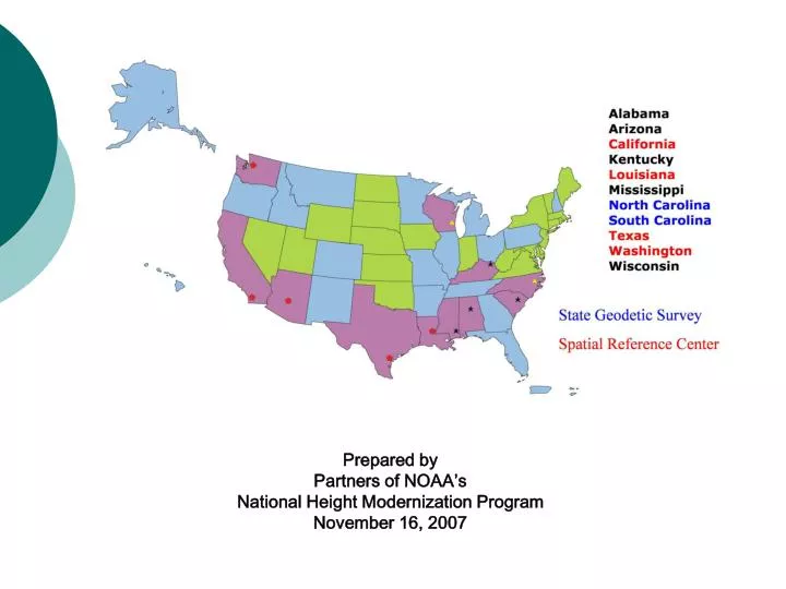
Prepared by Partners of NOAA’s National Height Modernization Program November 16, 2007. Partner representatives:. Roy Dokka, Louisiana Garey Gilley, Texas Gary Jeffress, Texas David Mooneyhan, Mississippi Gary Thompson, North Carolina Joseph Monroe, North Carolina

E N D
Prepared by Partners of NOAA’s National Height Modernization Program November 16, 2007
Partner representatives: • Roy Dokka, Louisiana • Garey Gilley, Texas • Gary Jeffress, Texas • David Mooneyhan, Mississippi • Gary Thompson, North Carolina • Joseph Monroe, North Carolina • Matt Wellslager, South Carolina • David Steele, Washington • John Canas, California • David Moyer, Wisconsin
Why we are here • We are partners for NOAA’s Height Modernization program including representatives from state and local governments, academia and the private sector • We are here to report on the activities and successes of this program and to offer our continued encouragement for support of this critical program which cuts across all NOAA’s mission goals • We have accomplished a lot but there is much work yet to do. We want to continue dialog with NOAA to find the best way we can help support in meeting the mission goals of NOAA, and serve our common constituents • We would like to have your input and recommendations about the direction we are going with the program and what more we can do
What Height Modernization Brings to NOAA’s Climate Goal • NSRS Supports GEOSS by providing positioning infrastructure formonitoring effects of climate change, like sea level rise, through the CORS program • GPS-Met Water vapor studies - fundamental to understanding the formation and propagation of weather; enhances capability for improved weather forecasting • Monitoring land velocities, effects of ground water extraction due to adverse affects of climate change; crustal motion (earthquakes, subsidence, uplift) • Accurate flood plain elevations to prepare for large rainfall events
What Height Modernization Brings to NOAA’s Ecosystem Goal: 1) Ecosystem Restoration • Surface Elevation Tables (SETs) connection to NSRS • Blackwater National Wildlife Refuge – sea level rising at 3.5 mm per year 2) Emergency response • Forest fires – providing accurate 3D digital mapping • Flooding – hurricanes, tsunamis, tornadoes & heavy rainfall events • Earthquakes – crustal movement 3) Precision agriculture – CORS network provides geospatial information to allow for • More efficient effective application of fertilizers/pesticides, irrigation • Increased crop production; minimal negative Environmental impact • Soil nutrient management
What Height Modernization Brings to NOAA’s Weather and Water Goal More accurate geospatial information for • Developing inundation and storm surge models for more accurate flood prediction • Local forecasts and warnings for extreme weather events using tide gauge and CORS data • Heights on levees/dunes/dams/streams • Flood damage mitigation, reservoir management
What Height Modernization Brings to NOAA’s Commerce & Transportation Goal Common consistent geospatial data for 1) Accurate GIS Mapping 2) Emergency response information 3) Under keel and overhead clearance for ships/ GPS buoys 4) Accurate vertical datum for ship channel maintenance and dredging 5) Airport obstruction surveys 6) Hurricane Routes
Building local capacity/partnerships HM Partners are helping NOAA with: • State Geodetic Surveys • State Geodetic Advisor Program • Spatial Reference Centers • Models, Tools: Gravity/geoid model; V-Datum; ionosphere; troposphere; Digital Elevation Models • Education/outreach/technology transfer • Enhance state and local partnerships