Download
1 / 20
210 likes | 487 Views
ENROUTE . Chapter 5 Review. Enroute Charts. High Altitude Above 18000’ jet routes Low Altitude Below 18000’ Victor airways. Low Altitude Enroute. Victor Airways Connect VORs, VOR/DMEs, VORTACs 8 nm wide to 51 nm 4.5 deg after 51 nm. Chart Altitudes. MEA MOCA MAA OROCA MRA MCA.

E N D
ENROUTE Chapter 5 Review
Enroute Charts • High Altitude • Above 18000’ • jet routes • Low Altitude • Below 18000’ • Victor airways
Low Altitude Enroute • Victor Airways • Connect VORs, VOR/DMEs, VORTACs • 8 nm wide to 51 nm • 4.5 deg after 51 nm
Chart Altitudes • MEA • MOCA • MAA • OROCA • MRA • MCA
Low Altitude Enroute Chart NOS • Miscellaneous • Blue or Green depicted airports mean same for civilian pilots • Special Use Airspace is charted on Low Altitude Charts • A clearance to cross SUA indicts permission to enter SUA • Most information can be found in legend (End of of Section A)
COMMUNICATIONS • As part of your clearance, a departure frequency is assigned • Switch when advised by tower or clear of local traffic pattern • Pause before transmitting
COMMUNICATIONS • Example: • Kansas City Center • KS24 • off SLN • 2,500 • climbing • 5,000
COMMUNICATIONS • When a new frequency is assigned, read back frequency. • Change freq., pause. • Transmit “who you are talking to, who you are, attitude, altitude” • Example: “Denver Center, KS71, Level, FL210”
REPORTING PROCEDURESRADAR/NONRADAR • Anytime • Leaving altitude • Leaving any assigned holding fix • Missed approach • <500 fpm climb/decent • TAS varies>5% or 10 kts • Time & altitude reaching a holding fix • Loss of Nav/Comm(Equip) • Unforecast weather
REPORTING PROCEDURESNONRADAR (position reports) • At required reporting points • I D • P osition • T ime • E levation • E TA next • N ext next
REPORTING PROCEDURESNONRADAR (position reports) • Example • KC center • KS81 • Salina • 1530 • FL300 • HYS 1545 • Lamar next
IFR Altitudes • Hemisphere Rule • From MEA or MOCA to 18000’ • Altitudes are from local altimeter setting • Course 180’ to 359’, Even thousands • Course 360’ to 179’, Odd thousands
IFR Altitudes • Above 18000’ • Flight Levels • Altimeter is set to 29.92”, PA • Sometimes conflicts occur • Altitudes still follow hemisphere rule (End of Chapter 5 Section B)
Holding Procedures • Holding is a waste of time. • Normally issued for spacing
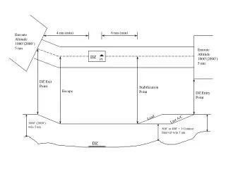
Holding Pattern • Race track shaped pattern • 1 Min Inbound legs <14000’ MSL • 1 1/2 min > 14000’ MSL • Standard holding pattern is right turns • At Nav facility, intersection, or Radial/DME
Holding Pattern • MAX Holding speed • >14000’, 265 KIAS • 6000’-13999’, 230 KIAS • <6000’, 200 KIAS