Download
1 / 45
450 likes | 532 Views
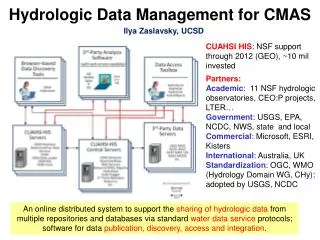
HydroServer A Platform for Sharing Hydrologic Data. http://his.cuahsi.org/. Jeffery S. Horsburgh , David G. Tarboton, Kimberly A. T. Schreuders, David R. Maidment, Ilya Zaslavsky, and David Valentine And the rest of the CUAHSI HIS Team. CUAHSI HIS Sharing hydrologic data. Support

E N D
HydroServerA Platform for Sharing Hydrologic Data http://his.cuahsi.org/ Jeffery S. Horsburgh, David G. Tarboton, Kimberly A. T. Schreuders, David R. Maidment, Ilya Zaslavsky, and David Valentine And the rest of the CUAHSI HIS Team CUAHSI HIS Sharing hydrologic data Support EAR 0622374
Outline • Data Models • Observations Data Model • HydroServer • Next Steps
Terrain flow information model.The way that data is organized can enhance or inhibit the analysis that can be done Pit Removal (Filling) Raw DEM Channels, Watersheds, Flow Related Terrain Information Flow Field
Observation Data Model for hydrologic and environmental measurementsThe way that data is organized can enhance or inhibit the analysis that can be done Groundwater levels Streamflow Precipitation & Climate Soil moisture data Flux tower data Water Quality
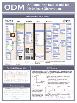
Why an Observations Data Model Provides a common persistence model for observations data Syntactic heterogeneity (File types and formats) Semantic heterogeneity Language for observation attributes (structural) Language to encode observation attribute values (contextual) Publishing and sharing research data Metadata to facilitate unambiguous interpretation Enhance analysis capability
Scope • Focus on Hydrologic Observations made at a point • Exclude Remote sensing or grid data. • Primarily store raw observations and simple derived information to get data into its most usable form. • Limit inclusion of extensively synthesized information and model outputs at this stage.
What are the basic attributes to be associated with each single data value and how can these best be organized?
“When” Time, T t A data value vi (s,t) “Where” s Space, S Vi “What” Variables, V CUAHSI Observations Data Model Groundwater levels Streamflow • A relational database at the single observation level (atomic model) • Stores observation data made at points • Metadata for unambiguous interpretation • Traceable heritage from raw measurements to usable information • Standard format for data sharing • Cross dimension retrieval and analysis Precipitation & Climate Soil moisture data Flux tower data Water Quality
Data Storage – Relational Database Values Sites Value Date Site Variable Site Name Latitude Longitude Simple Intro to “What Is a Relational Database”
Why Use a RDBMS • Mature and stable technology • Structured Query Language (SQL) • Sharing of data among multiple applications • Data integrity and security • Access by multiple users at the same time • Tools for backup and recovery • Reduced application development time
CUAHSI Observations Data Model http://his.cuahsi.org/odmdatabases.html Horsburgh, J. S., D. G. Tarboton, D. R. Maidment and I. Zaslavsky, (2008), A Relational Model for Environmental and Water Resources Data, Water Resour. Res., 44: W05406, doi:10.1029/2007WR006392.
What are the basic attributes to be associated with each single data value and how can these best be organized?
Site Attributes SiteCode, e.g. NWIS:10109000 SiteName, e.g. Logan River Near Logan, UT Latitude, Longitude Geographic coordinates of site LatLongDatum Spatial reference system of latitude and longitude Elevation_m Elevation of the site VerticalDatum Datum of the site elevation Local X, Local Y Local coordinates of site LocalProjection Spatial reference system of local coordinates PosAccuracy_m Positional Accuracy State, e.g. Utah County, e.g. Cache
Feature Observations Data Model Waterbody Watershed HydroPoint HydroID HydroID HydroID HydroCode HydroCode HydroCode * FType DrainID FType Name AreaSqKm Name AreaSqKm JunctionID JunctionID JunctionID NextDownID * * ComplexEdgeFeature SimpleJunctionFeature HydroEdge HydroJunction HydroJunction HydroJunction 1 HydroID 1 HydroID HydroID HydroID HydroCode HydroCode HydroCode HydroCode ReachCode NextDownID NextDownID NextDownID Name LengthDown LengthDown LengthDown LengthKm HydroNetwork DrainArea DrainArea DrainArea LengthDown FType FType FType FlowDir Enabled Enabled Enabled FType AncillaryRole AncillaryRole AncillaryRole EdgeType Enabled EdgeType Flowline Shoreline Independent of, but can be coupled to Geographic Representation Arc Hydro ODM 1 Sites 1 SiteID SiteCode SiteName OR Latitude Longitude … CouplingTable 1 SiteID HydroID 1
Variable attributes Cubic meters per second Flow m3/s VariableName, e.g. discharge VariableCode, e.g. NWIS:0060 SampleMedium, e.g. water ValueType, e.g. field observation, laboratory sample IsRegular, e.g. Yes for regular or No for intermittent TimeSupport (averaging interval for observation) DataType, e.g. Continuous, Instantaneous, Categorical GeneralCategory, e.g. Climate, Water Quality NoDataValue, e.g. -9999
quantity quantity quantity length or time length or time length or time Scale issues in the interpretation of data The scale triplet a) Extent b) Spacing c) Support From: Blöschl, G., (1996), Scale and Scaling in Hydrology, Habilitationsschrift, Weiner Mitteilungen Wasser Abwasser Gewasser, Wien, 346 p.
(a) spacing too large – noise (aliasing) (b) extent too small – trend (c) support too large – smoothing out The effect of sampling for measurement scales not commensurate with the process scale From: Blöschl, G., (1996), Scale and Scaling in Hydrology, Habilitationsschrift, Weiner Mitteilungen Wasser Abwasser Gewasser, Wien, 346 p.
Data Types • Continuous (Frequent sampling - fine spacing) • Sporadic (Spot sampling - coarse spacing) • Cumulative • Incremental • Average • Maximum • Minimum • Constant over Interval • Categorical
ValueAccuracy A numeric value that quantifies measurement accuracy defined as the nearness of a measurement to the standard or true value. This may be quantified as an average or root mean square error relative to the true value. Since the true value is not known this may should be estimated based on knowledge of the method and measurement instrument. Accuracy is distinct from precision which quantifies reproducibility, but does not refer to the standard or true value. ValueAccuracy Low Accuracy, but precise Accurate Low Accuracy
Loading data into ODM OD Data Loader • Interactive OD Data Loader (OD Loader) • Loads data from spreadsheets and comma separated tables in simple format • Scheduled Data Loader (SDL) • Loads data from datalogger files on a prescribed schedule. • Interactive configuration • SQL Server Integration Services (SSIS) • Microsoft application accompanying SQL Server useful for programming complex loading or data management functions SDL SSIS
6 5 7 4 1 3 2 At last … Work from Out to In And don’t forget … CUAHSI Observations Data Model http://www.cuahsi.org/his/odm.html
Managing Data Within ODMODM Tools • Query and export – export data series and metadata • Visualize – plot and summarize data series • Edit – delete, modify, adjust, interpolate, average, etc.
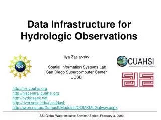
HydroServer Goals • A platform for publishing space-time hydrologic datasets that is: • Self contained fully documented with local control of data • Makes data universally available • Combine spatial data and observational data • Autonomous – e.g., functional independent of the rest of HIS
Point Observations Data Internet Applications Ongoing Data Collection Historical Data Files ODM Database GetSites GetSiteInfo GetVariableInfo GetValues GIS Data WaterML WaterOneFlow Web Service Data presentation, visualization, and analysis through Internet enabled applications HydroServer
http://hydroserver.codeplex.comhttp://icewater.usu.edu/maphttp://littlebearriver.usu.edu/http://hydroserver.codeplex.comhttp://icewater.usu.edu/maphttp://littlebearriver.usu.edu/
Syntactic Heterogeneity Multiple Data Sources With Multiple Formats Excel Files Text Files ODM Observations Database Access Files Data Logger Files From Jeff Horsburgh
Semantic Heterogeneity a United States Geological Survey National Water Information System (http://waterdata.usgs.gov/nwis/). b United States Environmental Protection Agency Storage and Retrieval System (http://www.epa.gov/storet/). c An equivalent to the USGS parameter code does not exist in data retrieved from EPA STORET. From Jeff Horsburgh
Overcoming Semantic Heterogeneity • ODM Controlled Vocabulary System • ODM CV central database • Online submission and editing of CV terms • Web services for broadcasting CVs ODM VariableNameCV Variable Name From Jeff Horsburgh
Dynamic controlled vocabulary moderation system ODM Data Manager ODM Website ODM Tools ODM Controlled Vocabulary Moderator XML Master ODM Controlled Vocabulary Local ODM Database ODM Controlled Vocabulary Web Services Local Server http://his.cuahsi.org/mastercvreg.html From Jeff Horsburgh
HydroServer Implementation in WATERS Network Information System National Hydrologic Information Server San Diego Supercomputer Center • 11 WATERS Network test bed projects • 16 ODM instances (some test beds have more than one ODM instance) • Data from 1246 sites, of these, 167 sites are operated by WATERS investigators
ICEWATER – A Regional HIS • ICEWATER – INRA Constellation of Experimental WATERsheds • Coalition of 8 universities • Point Observations • Stream gages • Water quality sampling • Weather stations • Soil moisture • Snow monitoring • Groundwater level/quality • Spatially Distributed Data • Land use/cover • Terrain • Hydrography http://icewater.inra.org MT WA ID OR WY AK NV CO UT CA AZ NM
Sustainability Principles • Servers maintain their own complete data and metadata. Local control of data that is complete and self describing • Adherence to standards • Open Source • Minimize custom programming • Maintain syntactic and semantic consistency • Data repositories are required
What’s next for HydroServer • Security and Data Access Control • Web based data loader • Data model enhancements • Flexibility in attributes • Moving platforms • Additional data types • Tighter integration with Hydrologic Ontology • Enhanced spatial data sharing
Proposed HydroServer Access Control HydroServer Services Security Service WaterOneFlow Web Service Data Store (ODM) Data consumer provides credentials User Authentication Security service returns a token Data consumer calls GetValues using the token The token is evaluated to see if the consumer is authentic and authorized True (Authorized), False (Not Authorized), or Error (Token Not Found) User Authorization and Data Access True – Get DataValues from the data store Returns DataValues Data Access Logged Data returned to consumer
Why Access Control • Significant feedback from academic users: • Control who can download data • How, when, and if data go from private to public • Publish papers before data are released • Track who is downloading their data • Have and use a data use/access agreement • Only expose the best or highest quality data • Integrate data organization, management, and publication • Some say that they will not publish their data using the CUAHSI HIS until they have access control
An online collaborative environment centered on the sharing of hydrologic data and models • Simple and easy to use • Find, create, share, connect, integrate, work together online • Leverage existing online sharing and collaboration platforms • Hydro value added
Purpose • Facilitate collaboration • Provide a place for HydroDesktop users to simply upload and publish data • Support immutable archive data collections as well as transient “work in progress” data sharing • Support seeing inside data collections to facilitate integration and synthesis across datasets
An example From Tim Whiteaker
CUAHSI Online Data analysis and publication use case 1 6 HydroDesktop Web Interface (HUBzero) 11 Observer or instrument 10 5 4 Web Services (WaterML) 2 7 8 9 3 Data Storage (iRODS) HydroServer HIS Central Present HIS CUAHSI Online
Summary • HydroServer provides a self contained autonomous data publication system • Local control of data, but universally accessible • Downloadable user (data publisher) configurable software stack that contains: • ODM and associated tools • WaterOneFlow web services • Geographic data sharing using WFS, WCS, WMS from ArcGIS server • Time Series Analyst • ArcGIS server based web map application • HydroServer Capabilities web service that publishes metadata about regions and services (observational and spatial) • Registering with HIS Central makes your data searchable
Questions? http://his.cuahsi.org/ CUAHSI HIS Sharing hydrologic data Support EAR 0622374