Download
1 / 79
800 likes | 960 Views
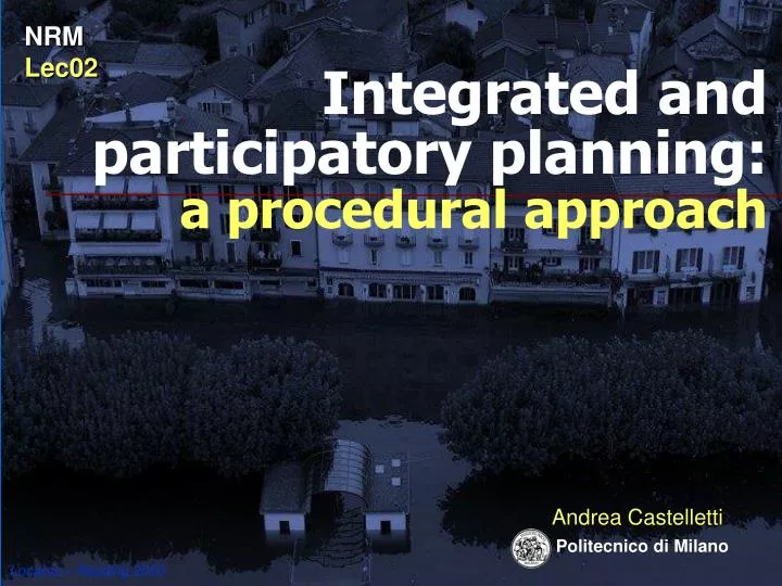
NRM Lec02. Integrated and participatory planning: a procedural approach. Andrea Castelletti. Politecnico di Milano. Locarno – flooding 2000. Miorina dam. river Ticino. Milan. Lake Maggiore. Inhabitants: 1.500.000 Irrigated area: 500.000 ha 50% of Italy’s rice production

E N D
NRM Lec02 Integrated and participatory planning: a procedural approach Andrea Castelletti Politecnico di Milano Locarno – flooding 2000
Miorina dam river Ticino Milan Lake Maggiore
Inhabitants:1.500.000 Irrigated area: 500.000 ha 50% of Italy’s rice production 30% of EU’s rice production
inflow t Natural lake flood stage level t release water demand t J D Why is Lake Maggiore regulated Regulated lake
2 1,5 1 0,5 Regulation range 0 Lake level [m] -0,5 -1 2-dic 6-apr 4-ago 15-ott 8-nov 1-gen 21-set 26-dic 17-giu 11-lug 18-feb 30-apr 13-mar 28-ago 25-gen 24-mag The regulation range
flood deficit Historical performance natural lake regulated history
flood deficit Historical performance natural lake regulated history To reduce lake flooding Switzerland proposes the excavation of lake outlet to Italy.
Excavation design (with a model) Proposal Stakeholders Public consultation Political decision How was the excavation designed? Problem definition The classical planning approach The proposal was rejected!
Why? • Only lakeside population will take advantage of the excavation. • What about the others: • - riverside population
Why? • Only the lake side population will take advantage of the excavation? • What about the others: • riverside population: • fears that increasing the release rate will cause larger floods; • farmers: fear that increasing the release rate will cause more severe droughts.
Why? • Only the lake side population will take advantage of the excavation? 2.The proposal (and the design) comes from one of the two parties involved, the other one (Italy) does not trust it
Dredging design (with a model) Proposal Stakeholders Public consultation Political decision How was the excavation designed? Problem definition What to do? Get more interests involved: swap excavation for reservoir capacity Make participatorydecisions The proposal was rejected! The approach is wrong!!! The classical planning approach
Dredging design (with a model) Proposal Stakeholders Public consultation Political decision Negotiate on positions Negotiate on interests Problem definition Positions: I want to excavate I want a larger reservoir Interests: Avoid floods Reduce droughts
Let’s experiencing a real negotiation Try to reach an agreement between Italy and Switzerland. Switzerland Upstream Italy Downstream Switzerland Upstream Italy Downstream
Dredging design (with a model) Proposal Stakeholders Public consultation Political decision Negotiate on positions Negotiate on interests To negotiate one needs to know the effects of the alternatives! Problem definition Interests: Avoid floods Reduce droughts Positions: I want to dredge I want a larger reservoir
Write your final agreement on a piece of paper e.g. Satisfaction Upstream 43 Downstream 22 or No Agreement
Dredging design (with a model) Proposal Stakeholders Public consultation Political decision Negotiate on positions Negotiate on interests To negotiate one needs to know the effects of the alternatives 1) Use models to evaluate in a “participatory” process the impacts of each alternative; 2)start a “social learning process”; 3)by means of which an “acceptable compromise” can be found. Problem definition Interests: Avoid floods Reduce droughts Integrated Water Resources Management IWRM Positions: I want to dredge I want a larger reservoir
IWRM paradigm is adopted by EU • Water Framework Directive (WFD) • establishes a framework for the protection of all waters • requires within 2009 the production of River Basin Management Plans (RBMP) to be prepared following the IWRM paradigm WFD Art. 13
Integration • of environmental objectives; • of all water uses, functions and values into a common policy framework water for health and human consumption, water for economic sectors, transport, leisure, etc. • of all significant management and ecological aspects … including those which are beyond the scope of WFD, such as flood protection; • of stakeholders and civil society in decision making [WFD CIS GD11]
The WFD guidelines states: “planning is a process” and requires “to provide procedural guidance on the production and development of River Basin Management Plans” supported byappropriate toolboxes,that “should help to identify the possible trade-offs among quantifiable objectives so that further debates and analysis can be more informed”. Moreover the toolboxes must support “planning as a systematic, integrative and iterative process”.
Procedure Procedure IWRM: the need for a procedure Problem definition Excavation design (with a model) Stakeholders Political decision
Problem formulation Setting the goal and identifying the constraints Designing alternatives/options ICT Tools Selecting the best compromise alternative 6. Comparison or negotiation Mitigation, and compensation, no reasonable alternatives Agreement? yes Final (political) decision 1. Reconnaissance 2. Conceptualisation 3. Designing Alternatives 4. Estimating effects Stakeholders MODSS 5. Evaluation PIP procedure Participatory and Integrated Planning procedure
among which environmental objectives, e.g. “good water status” and “sustainable uses”, as required by the WFD. 1. Reconnaissance • System understanding • Stakeholders identification • System definition in time and space • Institutional and legal analysis • Setting up the Objectives Stakeholders
inflow t Natural lake flood stage level t release water demand t J D Why is Lake Maggiore regulated Regulated lake
Coastline towns Upstream stakeholders
Coastline towns Natural reserve Upstream stakeholders
Coastline towns Natural reserve Navigation Upstream stakeholders
IRRIGATION DISTRICTS: Consorzio Est Sesia Consorzio Villoresi HYDROPOWER COMPANY Enel RIVER NATURAL PARKS Parchi Naturali della Valle del Ticino Downstream stakeholders
Sectors Upstream Downstream Flooding Flooding Tourism Tourism Environment Environment Fisheries Hydropower Navigation Irrigation Mosquitos
Problem objective Find a way of managing the lake that gathers a consent larger than the present one and enhances environmental quality (WFD requirements).
2. Conceptualisation Defining Actions (measures) 1. Reconnaissance Stakeholders
Farmers: change the regulation range Parks: improve environmental quality Lake manager: change the way the lake is presently regulated (regulation policy) Actions proposed by the stakeholders excavate the lake outlet Swisses: Italians:
More in general … wastewater treatment Types of actions structural normative flood gates Integrataed management management An alternative (program of measures) is a coordinated mix of instantiated actions Actions are instantiated when they clearly state “who is doing what and when”. The scope of planning is to identify the “best compromise alternative” regulation range regulation cap mef remeandering fish ladders water rights dykes using mines irrigation techniques
Alternative normative structural management decisions (daily) Farmers: change the regulation range Parks: improve environmental quality Lake manager: change the way the lake is presently regulated (regulation policy) Actions proposed by the stakeholders planning actions (once for ever) excavate the lake outlet Swisses: Italians: regulation policy (design it once for ever)
2. Conceptualisation Defining Criteria and Indicators Defining Actions(measures) 1. Reconnaissance Stakeholders
Harvest Distribution cost Supply deficit Crop stress An example of hierarchy: Irrigation Income Indicators are not necessarily quantitative
I_esM_C03 Maximum number of consecutive days of traffic interruption. [days] where: Di = number of days of the i-th flooding event; I = set of flooding events in the planning horizon.
Indicator: Flooded area 1,24 2,64 3,00 flooding threshold Historical max.(1993)
Flooded area 1993 – 2005 events
Upstream flooding: Land use parks services shopping a. …
Upstream flooding: Interruption in traffic Lakeside, 2000 Matteotti Square (213 cm). Cavour Square and promenade (124 cm). Corner Rosselli-Veneto (273 cm).
Upstream flooding: Walking Walkways extension. Raised walkways down town, 1997.
Another example: Upstream Environment Quality of the protected area Migration Birds Fish Wetland Ciprinidi reproduction Nest Water reeds Nanocipereti
Indicators 7 4 3 4 4 3 2 2 5 4 4 42 indicators Sectors Upstream Downstream Flooding Flooding Tourism Tourism Environment Environment Fisheries Hydropower Navigation Irrigation Mosquitos