Download
1 / 3
40 likes | 220 Views
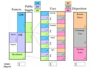
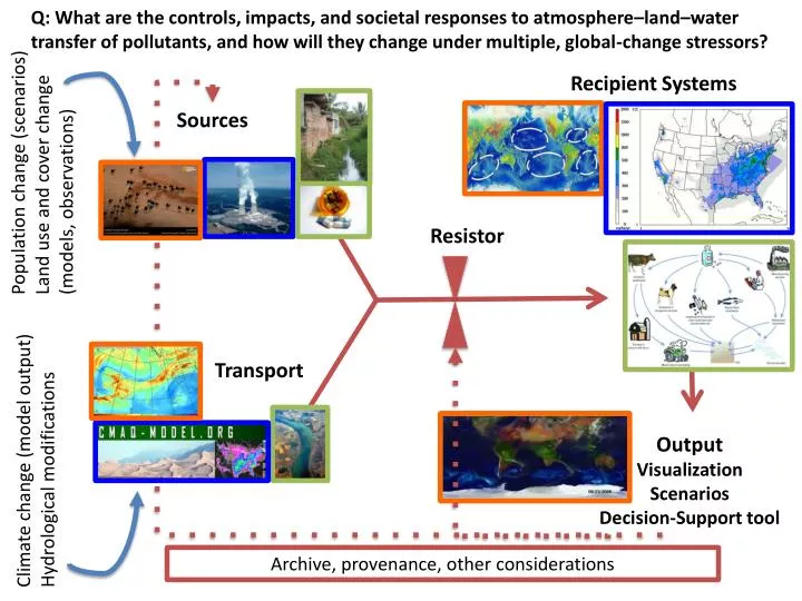
Q: What are the controls, impacts, and societal responses to atmosphere–land–water transfer of pollutants, and how will they change under multiple, global-change stressors?. Recipient Systems. Sources. Population change (scenarios) Land use and cover change (models, observations). Resistor.

E N D
Q: What are the controls, impacts, and societal responses to atmosphere–land–water transfer of pollutants, and how will they change under multiple, global-change stressors? Recipient Systems Sources Population change (scenarios) Land use and cover change (models, observations) Resistor Transport Output Visualization Scenarios Decision-Support tool Climate change (model output) Hydrological modifications Archive, provenance, other considerations
Observations of sources of pollutants • spatially explicit - satellite (e.g., MODIS), aerial imagery (need) • point sources: • power plant locations • - CAFOs • - wastewater treatment plants • - diffuse sources: • - fertilizers • - auto-transportation • - urban runoff • Sensor networks • USGS Gauge Network • other sensor networks (need) • Model output for spatial and time varying transport • CMAQ annual deposition SPARROW water quality model USGS • NASA models of aerosol movement • SMS and Delta3D for sediment transports • CMS for CDOM transport and oil-spills • WRI model for river discharge • Landscape and habitat models of recipient systems • GIS-based data from recipient systems (e.g., WRI, USGS, MCRMP, ReefGIS) • Spatial data on population/demographic characteristics • Inputs from models for changing conditions • Climate change model output at various scales • Population projections • Land-use change models Data Needs
Software Needs for Data & Model Output Synthesis • Modularity: main program with modules (off/on in parameter file) • Flexible I/O: • OPeNDAP (Open-source Project for Network Data Access protocol); • Storage: flexible output (netcdf, ASCII formats) and data archive system • Existing pollutant transport models • CMAQ annual deposition Community Modeling and Analysis System (CMAS) Center • SPARROW water quality model USGS • NASA models of aerosol movement • SMS and Delta3D for sediment transports • CMS for CDOM transport and oil-spills • Landscape and habitat models (USGS, WRI) Perturbations of IC (climate and land-use scenarios) • New transport models: Coupled atmospheric-ocean transport models • High Performance Computing with multi-processors and MPI capabilities • multi-scale nesting capabilities • hind-cast and near-real time capabilities • stochastic capabilities & ensemble simulations to formulate uncertainties • Output & Visualization Needs • user interface, interactive scenarios • connectivity module linking sources to recipients: where the pollution comes from? • Matlab2 & 3D animations • R - statistical package