Download
1 / 33
340 likes | 601 Views
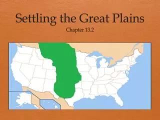
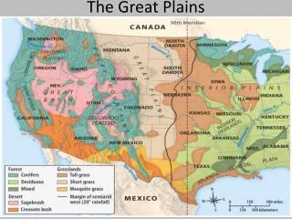
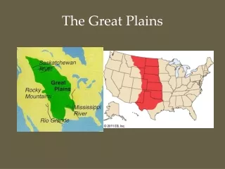
THE GREAT PLAINS AND PRAIRIES (CHAPTER 12). INTRODUCTION. The Great Plains and Prairies are outlined on p. 267. Regional Perspectives

E N D
INTRODUCTION • The Great Plains and Prairies are outlined on p. 267. • Regional Perspectives • Coronado explained, "this region is the best I've seen for producing the crops of Spain - the land is flat, soil is black, and is well watered with springs and rivers.” • Early 1800s - perceived to be wholly unfit for cultivation and uninhabitable for people depending on agriculture • Mid 1850s - labeled the "Great American Desert." • Historically - drastically different perceptions of the region's physical geography and its potential for settlement
GREAT PLAINS AND PRAIRIES
PHYSICAL GEOGRAPHY • Terrain • Elevation rises gently from east to west (500 meters to 1500 meters). • Southern half of the region has unvaried topography • Northern half is more variable and is characterized by “badlands.” • Very irregular topography resulting from wind and water erosion of sedimentary rock. • Widespread on the Missouri Plateau between northern Nebraska and the Missouri River • Best example in western South Dakota.
GREAT PLAINS & THE PRAIRIES
PHYSICAL GEOGRAPHY • Vegetation • Grasses are taller and more dense in the East and shorter and relatively sparse in the West. • Much of the grasses have intricate root systems, which were difficult to plow and often required "Bonanza teams" of about 20 animals to break the sod.
PHYSICAL GEOGRAPHY • Precipitation • Most precipitation in the region results from the interaction of air masses. • Amounts vary from 10-40 inches annually, decreasing from east to west. • About 75% of the precipitation falls from April through August. • Major droughts have occurred in 20 year cycles. • Significant droughts in the 1890s, 1910s, 1930s, 1950s, and 1970s
PHYSICAL GEOGRAPHY • Temperatures • Region experiences extremes in temperatures because of its continental climate • Fluctuations increase from south to north. • Northern Texas has over 240 frost free days each year, whereas Canada's prairies experience less than 90.
PHYSICAL GEOGRAPHY • Winds- serve as a mixed blessing to the region. • In late spring and summer, wind velocities in the central and northern Plains are among the highest in North America. • Ensures maximum efficiency for the region's windmills. • High rates of evaporation and transpiration may minimize the effects of precipitation.
WIND POWER “Certainty Rating of the Wind Resource”
PHYSICAL GEOGRAPHY • Chinooks - warm, dry, winter winds from the Pacific that bring welcomed relief during the winter months • Blizzards- characterized by snow, wind, & intense cold • Occur when cold polar air masses push south along the Rockies, and can last for several days • Tornadoes- pose a significant regional hazard. • Great Plains experience far more tornadoes annually than any other comparable area in the world. • Parts of Texas, Oklahoma, and Kansas encounter 200 - 300 per year, largely concentrated in the spring and early summer.
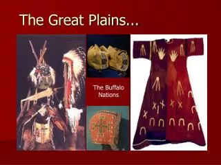
EARLY SETTLEMENT PATTERNS • Plains Indians • Pre-European occupation was limited. • Hunting for buffalo was the primary activity • Semi-permanent settlements were situated mainly along streams. • The Indians greatly improved their mobility once the early Spanish explorers left behind horses.
EARLY SETTLEMENT PATTERNS • Early Problem Areas • Average annual rainfall <<< that found in the East • Considerable variation in annual rainfall • Violent storms - high winds, hail, and tornadoes • Winter blizzards intensified the cold and blew snow into deep, impassable drifts. • The hot, dry winds of summer routinely carried away topsoil in clouds of dust. • Sparse natural water supply to support tree growth, so no wood for building, fuel, fencing, etc. • The ground was difficult to plow.
EARLY SETTLEMENT PATTERNS • Settlement had initially halted along the eastern margins. • Permanent Settlement was initially inspired by the Homestead Act. • Passed in 1863 • Gave 160 acres of land free to each settler • Encouraged settlement of the Great Plains. • 1867-1885- ranching was a viable alternative. • Late 1870s- barbed wire, lumber, and windmills helped to overcome environmental constraints.
AGRICULTURE • Large scale and machinery intensive • Wheat • Winter wheat • Grown from Northern Texas to Southern Nebraska. • Spring wheat • Areas with severe winters and cool summers • Located from central South Dakota to the south central Prairie Provinces of Canada. • U.S. and Canada are the world's leading exporters • Kansas and North Dakota lead all U.S. production. • Saskatchewan is by far Canada's largest producer.
AGRICULTURE • Shipment Patterns • Most Canadian wheat goes to Winnipeg then to Thunder Bay for shipment across the Great Lakes. In the West, it goes to Vancouver by rail and is then shipped by sea. • U.S. wheat shipments travel across the Great Lakes or down the Mississippi River.
AGRICULTURE • Key Terms • Migrant Labor • The term should not to be confused with migrant workers who harvest crops in other regions. • These workers comprise large crews that use numerous combines and trucks. • They travel from Texas in early June and follow the wheat harvest north into the Prairie Provinces • Accounts for about four months total work.
AGRICULTURE • Key Terms(continued) • Sidewalk Farmers are those farmers who live in town and travel to their various acreages nearby. • Suitcase Farmers are farmers who live far from their fields and only visit them occasionally, approximately four or five times a year, as in the case of those who own large wheat farms.
AGRICULTURE • Other Crops • Barley - important in the Canadian province of Alberta. • Sorghum - used for stock feed and grown throughout the hot, dry margins of the plains • Cotton - a dominant crop in Texas • Oats - grown throughout the Northern Plains area • Cattle
GROUND WATER “OVERDRAFT”
ENERGY RESOURCES • The Panhandle Field of Northwest Texas, Oklahoma, and Kansas is the world's leading supplier of natural gas. • All three states are major petroleum producers, along with Wyoming and Alberta. • Coal is abundant in Wyoming, which may be the leading producer in the U.S. by the year 2002. Lignite, a brownish, soft coal is also readily available in North Dakota.