Download
1 / 45
450 likes | 461 Views
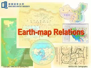
EARTH - MAP RELATIONSHIPS. The Size and Shape of the Earth. EARTH - MAP RELATIONSHIPS. The Size and Shape of the Earth. Globe. Flat Map. EARTH-MAP RELATIONSHIPS. 1. Definition of Geodesy 2. Shapes of the Earth 3. Geographic Coordinates 4. The Graticule 5. Geodetic Control Points.

E N D
EARTH - MAP RELATIONSHIPS The Size and Shape of the Earth
EARTH - MAP RELATIONSHIPS The Size and Shape of the Earth
EARTH-MAP RELATIONSHIPS 1. Definition of Geodesy 2. Shapes of the Earth 3. Geographic Coordinates 4. The Graticule 5. Geodetic Control Points
EARTH-MAP RELATIONSHIPS 1. Definition of Geodesy 2. Shapes of the Earth 3. Geographic Coordinates 4. The Graticule 5. Geodetic Control Points
1. GEODESY • The science concerned with determining the size and shape of the Earth • Establishment and maintenance of a global three-dimensional network of geodetic control points. • Measuring Geodynamic Phenomena (Geodynamics) • To Determine: • The exact positions of points on the earth’s surface • The size and shape of the earth • The variations in terrestrial gravity
EARTH-MAP RELATIONSHIPS 1. Definition of Geodesy 2. Shapes of the Earth 3. Geographic Coordinates 4. The Graticule 5. Geodetic Control Points
2. THE SHAPES OF THE EARTH • SPHERE • ELLIPSE • ELLIPSOID • GEOID • GEOID SEPARATION
THE SHAPES OF THE EARTH • SPHERE: • A body of space bounded by one surface all points of which are equally distant from a point (center). • Constant radius
THE SHAPES OF THE EARTH • ELLIPSE: The path of a point the sum of whose distances from two fixed points (the foci) is constant
THE SHAPES OF THE EARTH • ELLIPSE: Flattening:
THE SHAPES OF THE EARTH • ELLIPSE: Flattening: World Geodetic System ‘84 WGS ‘84 a = 6,371,137 meters b = 6,356,752.2142 meters f = 298.25722
THE SHAPES OF THE EARTH • ELLIPSOID (SPHEROID): Surface developed by rotating an ellipse about its minor axis (oblate spheroid - tomato shaped) or major axis (prolate spheroid - cigar shaped).
THE SHAPES OF THE EARTH • ELLIPSOID (SPHEROID):
THE SHAPES OF THE EARTH • GEOID: The equipotential surface of the Earth’s gravity field which coincides with the surface the oceans would have if they were motionless and affected only by the Earth’s gravity field.
THE SHAPES OF THE EARTH • GEOID: An exaggerated view of the geoid in relation to the ellipsoid and the sphere
GEOID SEPARATION • GEOID SEPARATION: The perpendicular distance from the reference ellipsoid to the geoid. + The Geoid is above the Ellipsoid - The Geoid is below the Ellipsoid WGS ‘84 Ellipsoid and Geoid ‘96: Maximum separation worldwide 100 meters In Continental U.S. - 20 meters
THREE EARTH SURFACES Geoid Height
“The Four Corners of the Earth” 1 2 4 3
GEOID - ELLIPSOID RELATIONSHIP STATION “DURHAM 1943” : • Located behind Kendall Hall • Geoid Height (Geoid 93 Model) = - 27.184 meters • 10 cm (3’ by 3’ Lat., Long. Grid) ( 100 km) • Geoid ‘96: 3 cm (1) (2’ by 2’ Lat., Long.) • Geoid ‘99: • Elevation 106.46’ (above “mean sea level”)
GEOID - ELLIPSOID RELATIONSHIP STATION “DURHAM 1943” :
GEOID - ELLIPSOID RELATIONSHIP STATION “DURHAM 1943” :
EARTH-MAP RELATIONSHIPS 1. Definition of Geodesy 2. Shapes of the Earth 3. Geographic Coordinates 4. The Graticule 5. Geodetic Control Points
3. GEOGRAPHIC COORDINATES • LATITUDE: • LONGITUDE:
3. GEOGRAPHIC COORDINATES • LATITUDE: The north-south position on the Globe “A Parallel”
3. GEOGRAPHIC COORDINATES • LONGITUDE: The east - west position on the Globe “AMeridian”
Orthogonal vs. Geographic Coordinates Ellipsoid Sphere Geographic Coordinates Orthogonal Coordinates “Authalic” Coordinates
3a. GEODETIC COORDINATES • LATITUDE Angle formed by a line from the equator to the center of the earth, and a second line perpendicular to ellipsoid’s surface at your location. Point
3a. GEODETIC COORDINATES • LONGITUDE Angle between a “prime” meridian and your “local” meridian. Point
REVIEW OF TOPICS EARTH-MAP RELATIONSHIPS 1.Definition of Geodesy 2. Shapes of the Earth 3. Geographic Coordinates 4. The Graticule 5. Geodetic Control Points
EARTH-MAP RELATIONSHIPS 1. Definition of Geodesy THE SCIENCE CONCERNED WITH DETERMINING THE SIZE AND SHAPE OF THE EARTH 2. Shapes of the Earth SPHERE, ELLIPSE, ELLIPSOID, GEOID, GEOID SEPARATION 3. Geographic Coordinates LATITUDE, LONGITUDE: GEOGRAPHIC (AUTHALIC) VS. GEODETIC, X,Y,Z