Download
1 / 40
400 likes | 507 Views
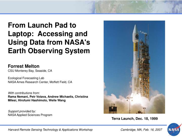
From Launch Pad to Laptop: Accessing and Using Data from NASA's Earth Observing System Forrest Melton CSU Monterey Bay, Seaside, CA Ecological Forecasting Lab NASA Ames Research Center, Moffett Field, CA With contributions from:

E N D
From Launch Pad to Laptop: Accessing and Using Data from NASA's Earth Observing System Forrest Melton CSU Monterey Bay, Seaside, CA Ecological Forecasting Lab NASA Ames Research Center, Moffett Field, CA With contributions from: Rama Nemani, Petr Votava, Andrew Michaelis, Christina Milesi, Hirofumi Hashimoto, Weile Wang Support provided by: NASA Applied Sciences Program Terra Launch, Dec. 18, 1999 Harvard Remote Sensing Technology & Applications Workshop Cambridge, MA, Feb. 16, 2007
Outline • NASA Earth Observing System (EOS) • Satellites • Instruments • Applications • EOS Data Information System • Accessing data • Data formats • Viewing and utilizing data • Future NASA satellite missions • Integrating satellite data with in-situ observations and ecosystem models • Terrestrial Observation & Prediction System Northeastern U.S., January 25, 2005Credit: MODIS Rapid Response Team
A Skyful of Satellites 3,100 orbiting satellites Over 845 844 active satellites Credit: Union of Concerned Scientists Credit: New York Times, 2/6/2007 Union of Concerned Scientists, Satellite Database http://www.ucsusa.org/global_security/space_weapons/whats-in-space.html
Earth Observing Satellites NASA NOAA USGS Brazilian Space Agency (INPE) Canadian Space Agency Centre National d'Etudes spatiales (CNES, France) Chinese National Space Admin. European Space Agency (ESA) Japan Aerospace Exploration Agency (JAXA) Indian Remote Sensing Agency Commercial satellites and many others
NASA’s Earth Observing System (EOS) EOS is collecting Earth remote sensing data for a 15 year global change research program Phase II began in December 1999 with the launch of the first EOS satellite, Terra Integrated Earth observations to advance understanding of Earth System http://eospso.gsfc.nasa.gov/
Multiple Instruments per Mission Example: MODIS on Terra & Aqua Terra SatelliteLaunched Dec. 18, 1999 with five instruments (ASTER, CERES, MISR, MODIS, MOPITT) Aqua SatelliteLaunched May 4, 2002 with six instruments (AIRS, AMSR-E, AMSU, CERES, HSB, MODIS) MODerate resolution Imaging Spectroradiometer Orbit: 705 km, 10:30 a.m. descending node (Terra) or 1:30 p.m. ascending node (Aqua), sun-synchronous, near-polar, circular Swath Dimensions: 2330 km (cross track) by 10 km (along track at nadir) Data Rate:10.6 Mbps (peak daytime); 6.1 Mbps (orbital average) Spatial Resolution: 250 m (bands 1-2), 500 m (bands 3-7), 1000 m (bands 8-36) Design Life: 6 years
EOS / Sensor Web Overview NASA Satellites UAV/Aircraft Ground Sensors EOS Users Fire / Event EOSDIS / DAACs Ancillary Data
EOS Atmospheric Measurements • A-Train Satellite Constellation • Collects nearly simultaneousmeasurements of: • aerosols • clouds • temperature • relative humidity • radiative fluxes Credit: Langley Research Center http://www-calipso.larc.nasa.gov/about/atrain.php
EOS Atmospheric Measurements EOS Project Science Officehttp://eospso.gsfc.nasa.gov/eos_homepage/for_scientists/index.php
EOS Atmospheric Measurements: Aerosol monitoring TOMS MODIS Rapid Response Credit: NASA MODIS MOD04 Aerosol Optical Depth Credit: Jeff Schmaltz, NASA GSFC Credit: K. Mubenga
EOS Cryosphere / Solar Radiation Measurements Terra / Aqua ICESat JASON-I LANDSAT 7 ACRIMSAT SORCE
EOS Cryosphere: Monitoring Ice Sheets and Glaciers Jan. 31, 2002 Mar. 5, 2002 GLAS onboard ICESat will extend NASA airborne instrument record to track changes in ice sheet extent and thickness. Larsen B Ice Shelf Collapse, 2002Credit: NSIDC MODIS, ETM+, and ASTER can be used to monitor extent of glaciers and ice sheets.
EOS Measurements: Fire & Vegetation Monitoring MODIS MOD14 Southeast Asia Thermal Anomalies, January 28, 2007Credit: MODIS Rapid Response Tracking vegetation condition with MODIS EVI in the Amazon Basin Credit: Huete et al. 2006. GRL 33.
EOS Measurements: Tracking Landscape Change in Mato Grasso MODISCredit: MODIS Rapid Response Team ASTERCredit: Morton et al. 2006. PNAS, 103(39).
NASA Sub-orbital Science Program AVARIS Data Cube 15 aircraft platforms supporting satellite missions, field campaigns, disaster response, and science missions A range of sensors, including: • AVIRIS (Airborne Visible Infrared Imaging Spectrometer) • AIRDAS (Airborne Infrared Disaster Assessment System) • HyMap • LIDAR and many others NASA AVIRIS, Dec. 2005 Mosaic, Buck Island, St. Croix, USVI Credit: Dr. Liane Guild, NASA ARC http://suborbital.nasa.gov/index.html
EOS Data Information System (EOSDIS) • EOSDIS is the comprehensive ground system for processing, archiving, and distributing data from all the EOS spacecraft • Data processed, archived and distributed from nine distributed active archive centers, each with its own focus • Accepts, process, and archives 3+ TB per day of data from EOS • > 4 petabytes of data archived • 2.3 TB of user data requests per day fulfilled • Also provides mission operation systems that perform command and control of the spacecraft and instruments, health and safety monitoring, mission planning and scheduling, initial data capture, and Level 0 processing. http://nasadaacs.eos.nasa.gov/about.htmlhttp://eospso.gsfc.nasa.gov/eos_homepage/data_services.php
Data Access: EOS Data Gateway • EOS data access provided by EOS Data Gateway (EDG) http://delenn.gsfc.nasa.gov/~imswww/pub/imswelcome/ (http://eos.nasa.gov/imswelcome) • Integrated search interface for all EOS data products • Facilitates search by data set, sensor, data type, location, and date • On-line manual and tutorial provided • NOAA Data Access • CLASS, http://www.class.ncdc.noaa.gov/nsaa/products/welcome • USGS Data Access • Earth Resources Observation Systems (EROS) Data Center (EDC), http://edc.usgs.gov/ • Access to some datasets requires NASA / NOAA / USGS collaboration EDG Data Query Interface
EOS Standard Products: Data Format • HDF (Hierarchical Data Format) • Designed at NCSA to facilitate sharing of scientific data • Embedded metadata for units, labels, other descriptors • Platform independent • User extendible • Supports multidimensional array, text, table, raster image, and palette • HDF-EOS (HDF for the Earth Observing System • Implemented as a C library extension of the standard HDF library • Adds support for grid, point, and swath formats to standard HDF objects • Allow file contents to be reference to Earth coordinates and time • Contains EOS Core System (ECS) core metadata essential for ECS search services (if the product contains ECS metadata, it is a valid HDF-EOS file) • Can be read by any tool that processes standard HDF files • http://science.hq.nasa.gov/research/earth_science_formats.htmlhttp://hdfeos.org/; http://earthobservatory.nasa.gov/Study/HDFEOS/
Other Common Data Formats GeoTIFF, http://remotesensing.org/geotiff/spec/geotiffhome.html • Public domain metadata standard that allows georeferencing information to be embedded within a TIFF • The potential additional information includes projections, coordinate systems, ellipsoids, datums, and everything else necessary to establish the exact spatial reference for the file. Network Common Data Form (netCDF), http://www.unidata.ucar.edu/software/netcdf/ • Interface for array-oriented data access and a freely distributed collection of software libraries for C, FORTRAN, C++, Java, and Perl that provide implementations of the interface • Many of the same features and advantages of HDF: (1) self-describing; (2) architecture-independent; (3) directly readable • Widely used for climate data, climate modeling, and other applications with multidimensional gridded datasets National Land Archive Processing System (NLAPS) Data Format (NDF), and Level 1 Product Generation System (LPGS), http://eros.usgs.gov/products/satellite/landsat7.html#processing • NLAPS and LPGS and Landsat data processing systems; image data are in GeoTIFF Flexible Image Transport System (FITS), http://fits.gsfc.nasa.gov/ • Used by astronomy research community (and the TRMM VIRS fire product) • Header records in ASCII text format, followed by data records, consisting of a byte stream. National Imagery Transmission Format (NITF) 2.1 / 2.0 • Used by Intelligence and Defense community (and Quickbird) Binary (flt / hdr) and American Standard Code for Information Interchange (ASCII) http://science.hq.nasa.gov/research/earth_science_formats.htmlhttp://outreach.eos.nasa.gov/EOSDIS_CD-03/docs/data_formats.htm
Other U.S. Sources of Satellite Data: NOAA & DMSP NOAA National Environmental Satellite, Data, and Information Service (NESDIS) • NESDIS, GOES, POES, METEOSAT, AVHRR • Data access via the NOAA Comprehensive Large Array-data Stewardship System (CLASS) http://www.osd.noaa.gov/class/ • Data formats: GeoTIFF, HDF, Binary, shapefile • Also provides access to the Defense Meteorological Satellite Program (DMSP) Archive • NESDIS data organized by four data centers: • Climate Data Center • Geophysical Data Center • Ocean Data Center • Coastal Data Center http://www.nesdis.noaa.gov/ http://www.noaa.gov/satellites.html
Other U.S. Sources of Satellite Data: USGS USGS maintains data for Landsat 1-7 missions and archive of aerial photography Data Access via EDC • http://landsat.usgs.gov/data_products/ordering_data.php • Earth Explorer • GloVis • IGS Network Landsat 7 SLC failure on May 31, 2003 continues to be problematic Progression of deforestation in Bolivia from 1975 to 2000. The MSS image on the left was acquired on June 17, 1975; the middle TM image on July 10, 1992; and the right ETM+ image on August 1, 2000. Credit: USGS Agriculture in Nevada. Scan Line Corrector anomaly creates a zigzag pattern along satellite ground track. Image acquired August 28, 2003. Credit: USGS http://landsat.usgs.gov/project_facts/files/landsat_fact_sheet_20023-03.pdf
Viewing and Analyzing Data Multiple commercial tools for viewing and analyzing commercial data: http://edcdaac.usgs.gov/landdaac/tools/hdf/tools_table.asp
Viewing and Analyzing Data • Open Source Remote Sensing Applications • RemoteSensing.org, http://remotesensing.org/Home.html http://edcdaac.usgs.gov/landdaac/tools/hdf/tools_table.asp
Viewing and Analyzing Data: HDF Tools • HDF-EOS Tools & Libraries, http://www.hdfeos.org/software.php • Provide functionality for viewing, analyzing, and converting HDF to other formats • Examples • Binary_Dumper -- dumps HDF-EOS objects in binary format • EOSVIEW -- displays and verifies HDF and HDF-EOS files • HDFExplorer -- visualization program that reads HDF, HDF-EOS and HDF5 files • HDFView -- a visual tool for browsing and editing NCSA HDF4 and HDF5 files • HE5View -- a file viewing tool for examining and verifying HDF-EOS 5.x files • HEG -- converts HDF-EOS to GeoTIFF • HEMU -- a tool to update metadata inside an HDF-EOS file • HMR -- reads metadata from HDF-EOS file and writes to a text file • HMU -- updates the metadata embedded in an HDF-EOS file • MS2GT -- reads HDF-EOS files containing MODIS swath data and produces flat binary files containing gridded data • PGS_Toolkit -- a set of tools to manage the metadata that are generated with each EOS product • PHDIS -- reads any HDF-EOS file containing data gridded in the Lambert Azimuthal Equal Area projection • hdf2bin -- converts HDF or HDFEOS file into plain binary file • hdfeos-netcdf -- converts HDF-EOS4/5 files to netCDF • view_hdf -- a visualizationtool for accessing data stored in HDF and HDF-EOS files
Future NASA Satellite Missions: 2008 Orbiting Carbon Observatory (ESSP / OCO) September 2008 Provide space-based observations of atmospheric carbon dioxide (CO2). Ocean Surface Topography Mission (OSTM) May 2008 Continue Jason and TOPEX/Poseidon Missions. Determine ocean surface topography to study ocean circulation and its environmental applications (cooperative with France, EUMETSAT, and NOAA). Glory December 2008 Continue SORCE Mission. Determine atmospheric aerosol properties from the polarization of backscattered solar radiation, and measure total solar irradiance. Earth System Science Pathfinder (ESSP) Program ESSP missions address unique, specific, highly-focused requirements in Earth science research. Primarily low to moderate cost, small to medium sized missions that are capable of being built, tested and launched in a short time interval.
Future NASA Satellite Missions: 2009-2010 LDCM Landsat Data Continuity Mission TBD Extend the Landsat record of multispectral, 30-m resolution, seasonal, global coverage of Earth’s land surface (joint with USGS). Global Precipitation Measurement (GPM) Mission TBD Measure global precipitation with improved temporal resolution and spatial coverage . NPOESS Preparatory Project (NPP) Mission September 2009 Extend key measurements in support of long-term monitoring of climate trends and global biological activity (joint NOAA-DoD-NASA mission). NPP extends the measurement series being initiated with EOS Terra and Aqua by providing a bridge between NASA’s EOS missions and NPOESS, scheduled to replace the separate NOAA and DoD operational systems in ~2010. ESSP Aquarius March 2009 Measure global sea surface salinity (cooperative mission with Argentina).
NASA Applied Sciences NASA Applied Sciences Application Plan, http://science.hq.nasa.gov/strategy/AppPlan.pdf
Applying EOS Data: TOPS Monitoring Modeling Forecasting Multiple scales Developing a Common Modeling Framework Use of ecosystem models to integrate satellite observations, climate data, and other ground-based observations and produce ecological forecasts. Predictions are based on changes in biogeochemical cycles http://ecocast.arc.nasa.gov/ White & Nemani, 2004, CJRS Nemani et al., 2003, EOM
TOPS California Ecological Daily Nowcasts at 1km Climate + Satellite Carbon and water cycles T P GPP ET 0 5 2.5 GPP (gC/m2/d) ET (mm/d) Biome-BGC Simulation models RAD Outputs include plant growth, irrigation demand, streamflow Salt water incursion, water allocation, crop coefficients
Mapping changes in global net primary production near real-time depiction of the droughts in the Amazon and Horn of Africa, May 2005 Near Real-time Monitoring of global NPP anomalies Running et al., 2004, Bioscience, 54:547-560
Lots of Data, One Laptop Data issues to consider: Spatial scale Temporal scale Cost Availability Data quality Length of data record Resources available for data analysis
Resources NASA Earth Science Reference Handbookhttp://eospso.gsfc.nasa.gov/eos_homepage/for_scientists/data_products/refbook2006.php EOS Data Products Handbook Vol. 1 (2004) and Vol. 2 (2000) http://eospso.gsfc.nasa.gov/eos_homepage/for_scientists/data_products/vol1.php Finding Data EDG: http://delenn.gsfc.nasa.gov/~imswww/pub/imswelcome/ DAACs: http://nasadaacs.eos.nasa.gov/search.html EOSDIS: http://spsosun.gsfc.nasa.gov/eosinfo/Welcome/index.html EOS-WEBSTER: http://eos-webster.sr.unh.edu/about.jsp EOS Imagery http://visibleearth.nasa.gov/ EOS Missions Mission Overviews: http://science.hq.nasa.gov/missions/earth.html Missions Profiles: http://eospso.gsfc.nasa.gov/eos_homepage/mission_profiles/index.php Instruments: http://eospso.gsfc.nasa.gov/directory/instrument/index.php Further Resources NASA Remote Sensing Tutorial: http://rst.gsfc.nasa.gov/ GIS Cafe Forums: http://www10.giscafe.com/wwwthreads-5.3/wwwthreads.php Instrument Science Teams