Download
1 / 1
10 likes | 116 Views
Spatially Explicit Modeling of Land-Use Change Rich Iovanna, EPA (OPEI/NCEE) & Colin Vance, German Aerospace Center (formerly of EPA). Why is land-use change of interest to EPA?

E N D
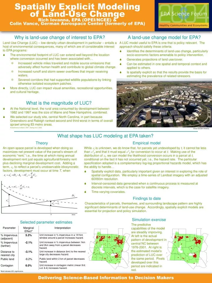
Spatially Explicit Modeling of Land-Use ChangeRich Iovanna, EPA (OPEI/NCEE) & Colin Vance, German Aerospace Center (formerly of EPA) • Why is land-use change of interest to EPA? • Land-Use Change (LUC) – low-density urban development in particular – entails a host of environmental consequences, many of which are of considerable interest to EPA programs: • The environmental footprint of LUC can extend well beyond the location where conversion occurred and has been associated with… • Increased vehicle miles traveled and mobile source emissions that adversely affect human health and contribute to global climate change. • Increased runoff and storm sewer overflows that impair receiving waters. • Severed corridors that had supported wildlife populations by linking otherwise isolated ecosystem patches. • More directly, LUC can impact visual amenities, recreational opportunities, and cultural heritage. • A land-use change model for EPA? • A LUC model useful to EPA is one that is policy relevant. The approach should satisfy these criteria: • Identifies the determinants of land-use change, particularly socio-economic factors amenable to policy intervention. • Generates projections of land use/cover. • Can be estimated in one spatial and temporal context and applied to others. • Is spatially explicit so that the results provide the basis for estimating the prevalence of related stressors. • What is the magnitude of LUC? • At the National level, the rural area consumed by development between 1982 and 1997 was the size of Maine and New Hampshire, combined. • We selected our study site, central North Carolina, in part because Greensboro and Raleigh ranked second and third worst in terms of overall sprawl among 83 metro areas. Kolankiewicz & Beck, 2001; Ewing et al. 2003 Smart Growth America What shape has LUC modeling at EPA taken? Theory An open-space parcel is developed when doing so maximizes net present value of the parcel’s stream of economic “rent,” i.e., the time at which rising annual development rent just equals agricultural/forestry rent plus declining marginal development cost. Adding a term, i, to reflect a parcel’s unobservable idiosyncratic factors, development must occur at time T, when • Empirical model • While i is unknown, we do know that, for parcels yet undeveloped by t, it cannot be less than *it and that it must equal *it for conversion to occur at t. Making use of the distribution of I, we can model the likelihood conversion occurs in a parcel at t, conditional on the fact it has not occurred yet, i.e., the hazard rate. The particular specification adopted is a complementary log-log proportional hazards model, which has the ability to handle… • Spatially explicit data, particularly important given an interest in exploring the role of spatial configuration. We employ a time-series of Landsat imagery with an adjusted 60X60m resolution. • Interval-censored data generated when a continuous process is measured at discrete intervals, which is the case for satellite imagery. • Time-varying covariates. Findings to date Characteristics of parcels, themselves, and surrounding landscape pattern are highly significant determinants of land-use change. Accordingly, spatially explicit models are essential for projection and policy simulation. Simulation exercise The predictive capabilities of the model are steadily improving. At left is the actual pattern of development in central NC between 1976-2001. At right is the estimated model’s prediction of LUC over the same period. Pixels developed over this period are indicated in red. Selected parameter estimates *Bold indicates 95% significance. Delivering Science-Based Information to Decision Makers