Download
1 / 37
370 likes | 547 Views
Earth Radiation Budget from NISTAR. Patrick Minnis NASA Langley Research Center May 11, 2007. - With help from Dave Doelling & Rabi Palikonda, SSAI. Why measure ERB from L1?. • NISTAR is an active cavity sensor - absolute calibrations

E N D
Earth Radiation Budget from NISTAR Patrick Minnis NASA Langley Research Center May 11, 2007 - With help from Dave Doelling & Rabi Palikonda, SSAI
Why measure ERB from L1? • NISTAR is an active cavity sensor - absolute calibrations • New approach to an old problem that requires more stitching of data and interpolation, etc. • Minimizes correction for missing hours • DSCOVR albedo and daytime OLR can serve as constraints on CERES & serve as a calibration source - a complementary approach • CERES is out of balance by 6 Wm-2
How do we measure ERB with DSCOVR? • • NISTAR measures TOT & SW radiances of entire disk, LW = SW-TOT • - Viewing & illumination geometry varies slowly over time within a narrow range of angles near the backscatter position • - Can only determine global albedo & daytime OLR • - Nocturnal OLR is an educated guess • • Radiance observations must be converted to irradiance (flux) • - Apply anisotropic directional models (ADMs) • Need cloud information • Other considerations
Changing View of Earth With Season March 21, 1986, 15° east from L1 April 15, 1986, 15°E of L1
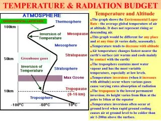
CORRECTION MODELS SW albedo • Small (2% to 8%) but variable sliver of sunlight is always out of view, depends on offset from L1 - Missing light correction • To determine albedo, a set of SW ADM correction models needed - Bidirectional reflectance correction OLR •Most of darkside Earth is never seen - Nightside correction • To determine OLR from LW radiance, a set of LW ADM correction models needed - Limb-darkening correction
Development of Correction Models & Analysis Approach • Initial study used ERBE scanner data - monthly averages • Most recent (2002) used ISCCP & ERBE combined - 3 hr => 1 hr - developed simulated NISTAR radiances - constructed correction factors for range of DSCOVR views - determined variability & estimated error in albedo - developed correction models: seasonal & L1 dependence => set of algorithms that can utilize cloud information to compute correction factors for any time & L1
DSCOVR Simulator • Construct hourly global radiation and cloud field - Convert 3-hr ISCCP GEO radiances to BB albedo (< 60° lat) - monthly NB-BB conversion ERBS/GEO - use ISCCP clouds to select ERBE ADM - normalize to ERBE (CERES TISA GEO method) - Use NOAA-9/10 ERBE data > 60° latitude - Interpolate to hourly using CERES TISA interpolations • Compute global ERB every hour • Use ISCCP clouds & regional albedos w/ ERBE ADMs to compute NISTAR radiances at specified UTC & L1 position, 1985-88 • Calculate correction factors for monthly mean radiance conversion
Testing Interpolation • normalize to ERBS, compare to NOAA-9 ERBE fluxes • RMS error least for all categories, but CS
Simulated albedo/reflectance field March 21, 1986, 15° east from L1
Mean SW parameters as function of L1 orbit position, March 1986 BDR Factor Missing light factor
Daily variability in missing light correction is small < 0.5%
Variation of monthly mean missing light factor as function of L1, 00 UTC
Mean LW parameters as function of L1 orbit position, March 1986 LD variability < 0.2% OLR (nightside) correction factor var < 1.1%
Variation of monthly mean nightside OLR factor as function of L1, 00 UTC
SUMMARY • Both diurnal and seasonal variability are significant for all DSCOVR correction parameters • Varibilities also sensitive to DSCOVR offset phase angle (from L1) • One year correction factors computed: • BRF1.1216 -- 1.1616SD0.0018 -- 0.0176 (1.5%) • MLCF1.0063 -- 1.0259SD0.0008 -- 0.0048 (0.5%) • LDC1.0354 -- 1.0519SD0.0002 -- 0.0012 (0.2%) • NSCF0.9448 -- 1.0083SD0.0021 -- 0.0106 (1.1%)
APPLICATIONS • Correction factors can be used independently to correct NISTAR measurements • will not account for dramatic scene changes • Need updating with CERES data and models • Same analysis approach can be used if cloud data and narrowband radiances available (CERES TISA approach) • should yield same radiance as CERES, on average, bias would indicate differences in calibration • Cloud data from EPIC insufficient • Cloud data from GEO + MODIS best option
Use Canned Correction Models • Perform fits to simulated data as function of month/day, L1 position, UTC, Fourier or EO fits • Apply to NISTAR observations • Unless drastic changes in scene distributions occur, monthly means should be extremely accurate • Night side? • ADM uncertainties?
Global Albedo Correction Model This model is designed to predict the corrected global mean albedo for given GMT and day: aglobal (tg,td) = atriana (qL1,fL1,tg,td)·Fa(qL1,fL1,tg,td) wheretgis the GMT andtd is the day of the year. Fa(qL1,fL1,tg,td)is the missing light albedo correction function. Fa(qL1,fL1,tg,td)=mnTmn(tg,td)·qnL1fmL1 where m, n=0, 1, 2, 3 and Tmn(tg,td)= ijCijtjgtid where i, j=0, 1, 2, 3.
Global OLR Correction Model This model is designed to predict the corrected global mean albedo for given GMT and day: OLRglobal (tg,td) = OLRtriana(qL1,fL1,tg,td)·FS(qL1,fL1,tg,td) wheretgis the GMT andtd is the day of the year. Folr (qL1,fL1,tg,td)is the OLR correction function. Folr(qL1,fL1,tg,td)=mnTmn(tg,td)·qnL1fmL1 where m, n=0, 1, 2, 3 and Tmn(tg,td)= ijCijtjgtid where i, j=0, 1, 2, 3.
Use External Cloud Data • CERES already performs a similar analysis, not real time - TISA algorithms the basis for simulation • CERES algorithms applied in real time GEO data subsets - global application only computer/manpower limited • Accounts for changes in climate, yields better daily values • Parallax problems? • ADM uncertainties?
Using GEO-LEO Data • Intercalibrate all GEOs and LEO imagers to a single source - done & ongoing • Apply common cloud retrieval algorithm - ongoing for subsets • Fusion:GEO-LEO can provide cloud clearing for aerosol & surface property retrievals
Cloud properties are derived every 30 minutes from GOES-11 & 12 over CONUS and merged - these include all of the same properties derived from MODIS for CERES Example: real-time cloud retrievals at 4 km resolution, 18 UTC, 7 Nov 2006 http://www-angler.larc.nasa.gov/satimage/products.html
Example: real-time cloud retrievals from MTSAT, 02 UTC, 7 Nov 2006
Example: full-disk cloud retrievals from Meteosat, 12 UTC, 26 April 2007
Example: full-disk cloud retrievals from GOES, 8 May 2007 GOES-11 (W) GOES-12 (E)
Parallax Problems: What size regions with VZA? Would we need to worry about this in making corrections? Will be a factor at all high VZA/SZA.
Summary • Capability to monitor global albedo/ERB globally from NISTAR - Estimate night side OLR, not true climate monitor - Cannot get regional scale ERB • Corrections do not appear to be highly variable interannually • need more data + new CERES models • Explicit corrections can be made using GEO-LEO data • Is this approach too redundant with CERES? • Or is it the means to constrain/compare CERES? • Basic algorithms developed for either approach - Need to be refined, streamlined, & documented
EPIC Notes • EPIC could be a good calibration reference - always has another imager with proper geometry • EPIC view angles, when matched with LEO/GEO imagers provide capability to estimate cloud particle habit/shape, aerosol & surface properties