Download
1 / 58
580 likes | 602 Views
Explore the layers of the Earth's interior, including the inner core, outer core, mantle, and crust. Learn about the processes that form the three types of rocks in the rock cycle: igneous, sedimentary, and metamorphic.

E N D
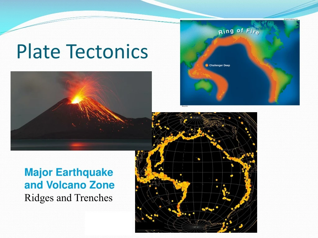
Plate Tectonics Major Earthquakeand Volcano Zone Ridges and Trenches
Earth’s Internal Layers Cross-Sectionof the Earth
Earth’s Internal Layers • The Earth’s interior consists of multiple layers: the inner core, the outer core, the mantle, and the crust • Based on 2008 seismic data, the inner core is thought to be solid and composed mainly of iron crystals • The entire inner core is 2,400 kilometers (1,491 miles) in diameter • inner core has an inner core 1,180 km (733 miles) in diameter • inner core has a temperature of 5,000˚C (9,032˚F) – nearly the same as the surface of the sun • inner core is theorized to be solid due to intense pressure
Outer Core • Outer core consists of the same elements at the same temperature as inner core • with less pressure, it is liquid • thickness is 2,270 km (1,411 miles) • outer core has thermal plumes - localized areas of high heat release possibly related to volcanic activity
Mantle • The mantle is the layer above the core and is approximately 2,900 kilometers (1,802 miles) in thickness • mantle contains mostly silicon and oxygen with some iron and magnesium. • Seismic wave studies give shape to the mantle’s structure • lower mantel is made of hot, dense magma (molten rock)
Upper Mantle • The upper mantle is composed of the asthenosphere and a portion of the lithosphere • asthenosphere is solid magma that flows slowly over time • lithosphere is the uppermost, rigid part of the upper mantle and the crust • Lithosphere = cool, solid rock portion of the outer Earth that rests on the warmer asthenosphere
Crust • outermost layer of the Earth • composed mainly of oxygen, silicon, magnesium, and iron. • varies in thickness • is the outer layer of the lithosphere • Low density magma from the asthenosphere rises and can eventually flow from a volcano or other opening in the crust • Lava - when molten rock exits the opening
The Rock Cycle • The three rock types found in the crust are: • Igneous • Sedimentary • Metamorphic. • Rocks form or change over long periods due to the processes of the rock cycle • One type is converted into another type
Igneous Rock • Igneous rocks form when magma or lava cools and hardens. • Granite and basalt are common examples • Igneous and other rock types break apart into rock particles due to weathering and water flow • Water flow carries away the rock particles, along with loose soil and particles of organic material. This process is called erosion • Wind, glaciers, and gravity cause erosion • Chemical processes break down and change rock through reactions • When the water flow slows or stops, the particles may be deposited as sediment
Sedimentary rock • sediments are slowly compressed and cemented together to form sedimentary rock • sediments contain organic matter • form rock in which fossils, coal, petroleum, and other fossil fuels are found • layers build up on top of each other • upper layers subject lower layers to increasing pressure and heat
Metamorphic rock • Metamorphic rock forms when pressure and heat become great enough to change the rock chemically • Rock may return to the mantle as part of plate tectonic processes • Subjected to the heat of the Earth’s interior • rocks remelt and become magma, returning to the crust as igneous rock
Floating crust • currently thought that the crust doesn’t sit on anything rigid, but literally floats on the mantle • continental crust (crust under the continents) consists primarily of granite • ocean crust (crust under ocean basins) consists primarily of basaltic rock • With the crust floating on the mantle, there must be a balance between the weight of the crust and the upward force of buoyancy
Archimedes Principle of buoyancy • Archimedes’ Principle of buoyancy states: • an object immersed in a fluid (gas or liquid) is buoyed up by a force equal to the weight of the fluid displaced. • An object that weighs less than the fluid it displaces will float. • If the weight of the crust changes, according to Archimedes’ Principle the landmass must rise or subside (sink) to compensate.
Isostatic Equilibrium • Isostatic equilibrium: balance between the weight of the crust and the buoyancy provided by the mantle • balance is disrupted as material adds to the oceanic crust (from deposition by sedimentation and volcanoes) or leaves the continental crust (from erosion) • additional weight causes the crust to deflect downwards, while the removal of material causes the crust to deflect upwards • called isostatic rebound
Isostatic Equilibrium • This is one theorized cause of earthquakes. To restore equilibrium, landmasses will sink or rise slightly along a weak area called a fault. • During an earthquake, the landmasses (continental or ocean basin) on either side of the involved fault do not move together.
Alfred Wegener • a German • meteorologist and polar explorer • proposed what was in 1912 a startling idea • Not accepted while he was alive
Alfred Wegener and Pangaea • He proposed: • that in the distant past all the Earth’s continents had been a single giant continent called Pangaea • Surrounding Pangaea was a single large ocean he called Panthalassa sepetjian.wordpress.com
Alfred Wegener and Pangaea • Wegener was the first to formally propose a process that explained the fit and present placement of the continents. • Wegener theorized that because the less dense continents floated on the molten rock of the mantle, Pangaea broke by floating apart into separate pieces. • The separate continents reached their present locations by drifting apart for more than 200 million years. • The theory that the continents were once a single landmass that drifted apart (and are still doing so) is called the theory of continental drift
Evidence for Continental Drift • In the 1600s, the first accurate world maps became available • continents apparently fit together like jigsaw-puzzle pieces • Continents match best on the edge of the continental shelf beneath the ocean water • First evidence of continental drift
Evidence for Continental Drift • In 1855, the German scientist Edward Suess found fossils of the Glossopteris fern in South America, Africa, Australia, India, and Antarctica. • Seeds of this fern are too heavy to travel by wind and too fragile to survive significant sea crossings • Landmasses must have once been much closer together for the fern to be so widespread
Evidence for Continental Drift • Continental drift proponents also studied the distribution of animals and fossils. • Two examples were the extinct aquatic reptile Mesosaurus and an extinct bear-like animal called Lytrosaurus. • Based on the distribution of fossils for these animals, it was hypothesized that Pangaea had split into two continents about 200 million years ago. • Laurasia, name of hypothetical northern continent • It included today’s North America, Greenland, and Eurasia • Gondwanaland, name of the southern continent which included the remaining continents
Evidence for Continental Drift • Wegener also saw the distribution of coal as evidence • In 1908, the famed polar explorer Ernest Shackleton discovered coal in the Antarctic • Scientists theorize that coal originates when geological processes bury vegetation in warm, swampy climates faster than it can decompose • Pressure and heat alter the vegetation, eventually turning it into coal • Wegener reasoned Antarctica must have been in a different place with a different climate in the past
New Technology and Seafloor Knowledge • The invention of Sonar made it possible to “see” long distances under water • Sonar detects objects under water by transmitting a sound and receiving an echo • Based on the echo’s angle, how long it took to return, and changes in frequency • can determine where an object is, its distance, and whether it’s moving
Sonar • an acronym for Sound Navigating And Ranging • Sonar made it possible to detect an otherwise invisible iceberg 5 kilometers (3.1 miles) away • Scientists began using an echo sounder – • essentially modified sonar specifically for mapping bottom terrain • ability to map the seafloor in greater detail revealed important new features
Seafloor Discoveries • A 70,000-kilometer (43,497-mile) mountain range that extends through the Atlantic, Indian, and Pacific Oceans. • trenches, which are deep ravines in the seafloor • rift valleys, which are deep valleys running through the center of the Mid-Atlantic Ridge and other mid-ocean ridges
Seafloor Creation and Destruction a theory of seafloor spreading • seafloor is in a constant state of creation and destruction • New crust emerges from the rift valley in a mid-ocean ridge • Magma pushes up through the rift and solidifies into new crust • New seafloor near the ridge continuously pushes old seafloor away from the ridge
Seafloor Creation and Destruction • Old seafloor subsides (sinks) at the trenches • Old seafloor is drawn downward by gravity and inertia, eventually reaching the asthenosphere and melting into magma again • new seafloor forms at the rift valleys and mid-ocean ridges • spreads away from the ridges until it returns to magma at subduction zones (trenches)
Evidence of Seafloor Spreading • There are several forms of evidence that support the theory of seafloor spreading. • Radiometric dating. • Ocean-bottom sediment samples. • Evidence is supplied by rheology. • Magnetometer data. • Since about 1990, geodesistshave been measuring platemovements directly.
Evidence of Seafloor Spreading Radiometric Dating of the Seafloor
Geomagnetic reversals • basalt—the iron-rich, volcanic rock making up the ocean floor—contains a strongly magnetic mineral (magnetite) and can locally distort compass readings • When these magnetic patterns were mapped over a wide region, the ocean floor showed a zebra-like pattern • one stripe with normal polarity and the adjoining stripe with reversed polarity • stripes are symmetrical around the crests of the mid-ocean ridges
Alternating Polarity of mid-ocean ridgeevidence of seafloor spreading
Birth of Plate Tectonics- a unifying theory • In 1965, Canadian geophysicist John Tuzo Wilson introduced a new theory that united the theories of continental drift and seafloor spreading • Earthquakes, volcanic activity, mountain-building, and oceanic trench formation occur along these plate boundaries
Tectonic Plates • The lithosphere is broken up into tectonic plates • The plates are rigid and float on the asthenosphere. • there are seven or eight plates, depending on how they are defined and many minor plates. • As plates move, they collide in some places, separate or slide side-by-side in others • Where plates meet their relative motion determines the type of boundary: convergent, divergent, or transform. • The lateral relative movement of the plates typically varies from zero to 100 mm annually
Seafloor Spreading andContinental Drift Combine Earth’s Crustal Plates
Transform boundary or fault • At a transform boundary or fault, two plates slide past each other. • In the United States, perhaps the most well-known of these is the San Andreas Fault in California. • The plate to the west of the fault is moving north, while the plate to the east is moving south. • Earthquakes result as rocks move when the plates slide next to each other.
The San Andreas Fault Fault
Seafloor Spreading andContinental Drift Combine • At a spreading or divergent boundary, two plates are moving apart • The crust pulls apart and forms valleys • Mid-ocean ridges and rift valleys mark divergent boundaries • Magma from the asthenosphere flows up through the rift valley where the plates separate, creating new crust and widening the seafloor • Besides forming new seafloor, volcanic activity at a divergent boundary may build mountains higher than sea level • This builds islands such as Iceland
Rift Valleys: Dead Sea, Red Sea, Loch Ness Divergent Boundary: Because new crust forms there, divergent boundaries are also called constructive boundaries
Seafloor Spreading andContinental Drift Combine • At a colliding or convergent boundary, two plates push together • Convergent boundaries are also called destructive boundaries because movements along the boundaries destroy crust
3 types of plate collision • The first occurs between two oceanic plates • In this collision, one plate is subducted under (sinks beneath) the other • This can result in a chain of volcanic islands or an island arc
Subduction and Volcanoes • The second type of plate collision occurs between oceanic and continental plates • The more dense oceanic plate is subducted under the less dense continental plate • This subduction occurs in trenches • A range of volcanic mountains may form at the edge of the continental plate as molten rock from the oceanic plate rises
Mountains fold and thrust up • The third type of collision occurs between two continental plates • when two continental plates collide, mountains form as the crust folds • The Himalayas are thought to still be forming as the Indo-Australian Plate pushes into the Eurasian Plate.
Hot Spots • What makes the hot spot theory significant is the concept that hot spots do not move with tectonic plates. • Explains the nature of features forming away from plate boundaries • Hot spots originate in the mantle, so the volcanic areas change on the plate as it moves over the hot spot. • This results in a line or row of volcanic formations. • Volcanic island chains result from the plate moving over a hot spot
Hot Spots • Example- hot spot under the Pacific Plate that created the Emperor Seamountsand Hawaiian Islands • formed from a hotspot as the plate movednorthwest over the last35 million years


